The governor of Victoria is the representative of the monarch, Queen Elizabeth II, in the Australian state of Victoria. The governor is one of seven viceregal representatives in the country, analogous to the governors of the other states, and the governor-general federally.

Broadmeadows is a suburb of Melbourne, Victoria, Australia, 16 km (9.9 mi) north of Melbourne's central business district. Its local government area is the City of Hume. At the 2016 Census, Broadmeadows had a population of 11,970.

Mount Victoria is a small township in the Blue Mountains of New South Wales, Australia. It is the westernmost village in the City of Blue Mountains, located about 120 kilometres (75 mi) by road from the Sydney central business district and at an altitude of about 1,052 metres (3,451 ft) AHD . The settlement had a population of 823 people at the 2011 Census.

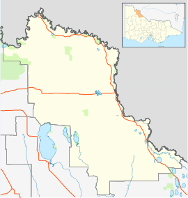
Murrayville is a town on the section of the Mallee Highway and Pinnaroo railway line between Ouyen and the South Australian border. It is about 24 kilometres (15 mi) east of the South Australian border and 536 kilometres (333 mi) north west of the state capital Melbourne, but 268 kilometres (167 mi) east of Adelaide. At the 2016 census, Murrayville had a population of 280, down from 444 ten years before.
Australian non-residential architectural styles are a set of Australian architectural styles that apply to buildings used for purposes other than residence and have been around only since the first colonial government buildings of early European settlement of Australia in 1788.
Krasnogruda is a village in the administrative district of Gmina Sejny, within Sejny County, Podlaskie Voivodeship, in north-eastern Poland, close to the border with Lithuania.
Boinka is a locality situated on the section of the Mallee Highway and Pinnaroo railway line between Ouyen and the South Australian border in the Sunraysia region of Victoria, Australia. Boinka is situated approximately 4 kilometres east from Tutye and 8 kilometres west from Linga.

Piangil, once frequently spelled "Pyangil", is a town in the Mallee region of northern Victoria, Australia. It is approximately 382 kilometres (237 mi) north west of the state capital, Melbourne and 46 kilometres (29 mi) north west of the regional centre of Swan Hill. At the 2016 census, Piangil and the surrounding rural area had a population of 259.

The Post Office Gallery is an art gallery in Ballarat, Victoria, Australia.

Postcodes in Australia are used to more efficiently sort and route mail within the Australian postal system. Postcodes in Australia have four digits and are placed at the end of the Australian address, before the country. Postcodes were introduced in Australia in 1967 by the Postmaster-General's Department and are now managed by Australia Post, Australia's national postal service. Postcodes are published in booklets available from post offices or online from the Australia Post website.
Hattah is a locality in Victoria, Australia located approximately 70 km south of Mildura. Located adjacent to Hattah is the Hattah-Kulkyne National Park.
Carwarp is a locality in Victoria, Australia, approximately 36 km from Mildura, Victoria. Carwarp was the home town of Percy Stewart, a founding member of the Victorian Farmers Union, from which the Country Party emerged. Stewart served in both the Victorian Legislative Assembly, where he represented the electoral district of Mildura, and in the federal parliament for the Australian House of Representatives electorate of Wimmera. Another parliamentarian from Carwarp was Albert Allnutt, who represented the electoral district of Mildura in the Victorian Legislative Assembly from 1927 until 1945.
Bunguluke is a locality in Victoria, Australia, located approximately 17 km from Wycheproof, Victoria.

Ninda is a locality in Victoria, Australia, located approximately 13 km from Sea Lake, Victoria.
Towaninny is a locality in the Victoria, Australia, located approximately 35 km from Wycheproof, Victoria.
Nowie is a locality in Victoria, Australia, located approximately 26 km from Swan Hill, Victoria.
Springfield is a locality in Victoria, Australia, located approximately 53 km from Swan Hill, Victoria.

The General Post Office, situated on the corner of Elizabeth and Bourke streets in Melbourne, is the former General Post Office for Victoria, Australia.

General Post Office a colonial-era building situated on 141 King William Street on the north-west corner of King William Street and Victoria Square, is the former General Post Office for South Australia, Australia, Postal services operated from the building between 6 May 1872 and 11 October 2019.

Victoria Park Post Office is a heritage-listed post office at 414 Albany Highway, Victoria Park, Western Australia, Australia. It was added to the Australian Commonwealth Heritage List on 22 August 2012.