The governor of Victoria is the representative of the monarch, currently King Charles III, in the Australian state of Victoria. The governor is one of seven viceregal representatives in the country, analogous to the governors of the other states and the governor-general federally.
Euroa is a town in the Shire of Strathbogie in the north-east of Victoria, Australia. At the 2021 census, Euroa's population was 3,116.

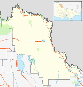
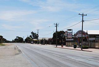
Rushworth is a township in Victoria, Australia. It is located 157 kilometres (98 mi) north of Melbourne and, at the 2016 Census, had a population of 1,335.

Nyah West is a town in Victoria (Australia) near the Murray River, the border with New South Wales. It is near the Murray Valley Highway, 371 kilometres (231 mi) north-west of Melbourne and 27 kilometres (17 mi) north-west of Swan Hill.

Murrayville is a town on the section of the Mallee Highway and Pinnaroo railway line between Ouyen and the South Australian border. It is about 24 kilometres (15 mi) east of the South Australian border and 536 kilometres (333 mi) north west of the state capital Melbourne, but 268 kilometres (167 mi) east of Adelaide. At the 2016 census, Murrayville had a population of 280, down from 444 ten years before.
Australian non-residential architectural styles are a set of Australian architectural styles that apply to buildings used for purposes other than residence and have been around only since the first colonial government buildings of early European settlement of Australia in 1788.

Newlyn is a town in the Shire of Hepburn, in Victoria, Australia. It is situated on the Midland Highway between Creswick and Daylesford. At the 2021 census, Newlyn had a population of 136.

Darbalara is a rural community on the east bank of the junction of the Murrumbidgee River and Tumut River in the Riverina. It is situated by road, about 25 kilometres north east of Gundagai and 25 kilometres south of Coolac.
Boinka is a locality situated on the section of the Mallee Highway and Pinnaroo railway line between Ouyen and the South Australian border in the Sunraysia region of Victoria, Australia. Boinka is situated approximately 4 kilometres east from Tutye and 8 kilometres west from Linga.
Nyah is a town in northern Victoria, Australia. The town is located on the Murray Valley Highway, in the Rural City of Swan Hill local government area, 365 kilometres (227 mi) north west of the state capital, Melbourne. At the 2016 census, Nyah had a population of 530.

Cowangie is a locality situated on the section of the Mallee Highway between Ouyen and the South Australian border in the Sunraysia region of Victoria, Australia. The place by road, is situated about 12 kilometres southeast from Tutye and 12 kilometres northwest from Danyo.

Longwarry is a town in Victoria, Australia, 83 kilometres (52 mi) south-east of Melbourne's Central Business District, located within the Shires of Baw Baw and Cardinia local government areas. Longwarry recorded a population of 2,436 at the 2021 census.
Carwarp is a locality in Victoria, Australia, approximately 36 km from Mildura, Victoria. Carwarp was the home town of Percy Stewart, a founding member of the Victorian Farmers Union, from which the Country Party emerged. Stewart served in both the Victorian Legislative Assembly, where he represented the electoral district of Mildura, and in the federal parliament for the Australian House of Representatives electorate of Wimmera. Another parliamentarian from Carwarp was Albert Allnutt, who represented the electoral district of Mildura in the Victorian Legislative Assembly from 1927 until 1945.
Cocamba is a locality in Victoria, Australia, located approximately 10 km from Manangatang, Victoria.

Lascelles is a town in Victoria, Australia, located approximately 113 km from Swan Hill, Victoria. In the 2016 census the state suburb of Lascelles had a population of 93.
Waitchie is a locality in Victoria, Australia, located approximately 44 km (27 mi) from Swan Hill, Victoria. At the 2006 census, Waitchie had a population of 118, decreasing to 48 at the 2016 census.
Goschen is a locality in Victoria, Australia, located approximately 20 km from Swan Hill, Victoria.

Mywee is a locality in northern Victoria, Australia. It is in the local government area of Shire of Moira. Mywee was also known as "Sheepwash Creek".

The General Post Office, situated on the corner of Elizabeth and Bourke streets in Melbourne, is the former General Post Office for Victoria, Australia.
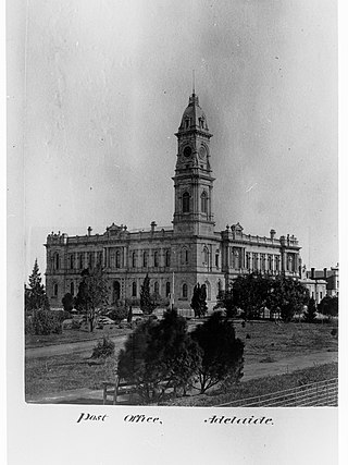
General Post Office, a colonial-era building situated on 141 King William Street on the north-west corner of King William Street and Victoria Square, is the former General Post Office for South Australia, Australia, Postal services operated from the building between 6 May 1872 and 11 October 2019.