
The Hattah-Kulkyne National Park is a national park in the Mallee district of Victoria, Australia. The 48,000-hectare (120,000-acre) national park is situated adjacent to the Murray River, approximately 417 kilometres (259 mi) northwest of Melbourne with the nearest regional centre being Mildura. The Hattah Lakes National Park was proclaimed on 7 June 1960, later being greatly expanded in 1980 and becoming the Hattah-Kulkyne National Park. It is a popular destination for bushwalkers and school camping trips.

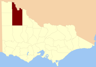
The Murray-Sunset National Park is the second largest national park in Victoria, Australia, located in the Mallee district in the northwestern corner of the state, bordering South Australia. The 633,000-hectare (1,560,000-acre) national park is situated approximately 440 kilometres (270 mi) northwest of Melbourne and was proclaimed in 1991. It is in the northwestern corner of the state, bordering South Australia to the west and the Murray River to the north. The Sturt Highway passes through the northern part of the park, but most of the park is in the remote area between the Sturt Highway and the Mallee Highway, west of the Calder Highway.

Mildura is a regional city in north-west Victoria, Australia. Located on the Victorian side of the Murray River, Mildura had a population of 34,565 at the 2021 census. When nearby Wentworth, Irymple, Nichols Point, Merbein and Red Cliffs are included, the combined urban area had a population of 58,914 in 2021, having grown marginally at an average annual rate of 1.3% year-on-year over the preceding five years.

Calder Highway is a rural highway in Australia, linking Mildura and the Victoria/New South Wales border to Bendigo, in North Central Victoria. South of Bendigo, where the former highway has been upgraded to freeway-standard, Calder Freeway links to Melbourne, subsuming former alignments of Calder Highway; the Victorian Government completed the conversion to freeway standard from Melbourne to Bendigo on 20 April 2009.
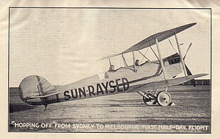
Sunraysia is a region located in northwestern Victoria and southwestern New South Wales in Australia. The region is renowned for its sunshine, intensive horticulture including grapes and oranges. Its main centre is Mildura, Victoria.

Robinvale is a town on the south bank of the Murray River in north western Victoria, Australia. It is connected by a bridge to Euston on the other side of the river in New South Wales. At the 2021 census, Robinvale had a population of 3,740, however a population study conducted by the Rural City of Swan Hill that was undertaken in 2019 identified Robinvale had an estimated population of between 7,000 in November and 8,800 in March each year.
Adams Mine is an abandoned open pit iron ore mine located in the Boston Township of the District of Timiskaming, 11 km (6.8 mi) south of Kirkland Lake in the Canadian province of Ontario. It is situated on the Canadian Shield.

The Mallee is a sub-region of Loddon Mallee covering the most north-westerly part of Victoria, Australia and is bounded by the South Australian and New South Wales borders. Definitions of the south-eastern boundary vary, however, all are based on the historic Victorian distribution of mallee eucalypts. These trees dominate the surviving native vegetation through most of Mallee,. Its biggest settlements are Mildura and Swan Hill.

Ouyen is a town in Victoria, Australia, located in the Rural City of Mildura at the junction of the Calder Highway and Mallee Highway, 105 kilometres (65 mi) south of Mildura, and 441 km (274 mi) northwest of Melbourne. At the 2016 census, the town had a population of 1,045.

Yelta is a locality in Victoria, Australia. It was for a short time in the 1870s and 1880s the Victorian administrative centre of what is now Sunraysia and the Millewa. This role was then taken over by Mildura. At the 2011 census, Yelta and the surrounding area had a population of 281.

The Wimmera River, an inland intermittent river of the Wimmera catchment, is located in the Grampians and Wimmera regions of the Australian state of Victoria. Rising in the Pyrenees, on the northern slopes of the Great Dividing Range, the Wimmera River flows generally north by west and drains into Lake Hindmarsh and Lake Albacutya, a series of ephemeral lakes that, whilst they do not directly empty into a defined watercourse, form part of the Murray River catchment of the Murray-Darling basin.

The Piangil railway line is a 5 ft 3 in gauge railway line in north-western Victoria, Australia. It branches off the Deniliquin line just north of Bendigo, and runs in a north-westerly direction through Pyramid Hill and Kerang to the border town of Swan Hill, then roughly parallels the New South Wales border to Piangil and Yungera. The line is now open only as far as Piangil, and passenger services only operate to Swan Hill.
The County of Karkarooc is one of the 37 counties of Victoria which are part of the cadastral divisions of Australia, used for land titles. It is located to the south of the Murray River, with its western boundary at 142°E, and its eastern boundary at 143°E. Its southern boundary is on the 36°S parallel. Lake Tyrrell is located near the eastern boundary. Mildura is located near the north-western edge.
Peter Laurence Crisp is an Australian politician. He was a member of the Victorian Legislative Assembly from 2006 to 2018, representing Mildura. He was formerly a Wentworth Shire Councillor.
The regions of Victoria vary according to the different ways that the Australian state of Victoria is divided into distinct geographic regions. The most commonly used regions are those created by the state government for the purposes of economic development.

The Victorian Railways Y class was a class of 0-6-0 steam locomotives.

The Morkalla railway line was a railway in the Millewa region of north-western Victoria, Australia. It extended west from Red Cliffs railway station on the Mildura railway line into wheat farming areas established as soldier settlements after World War I.
The Murray Basin Rail Project is a major railway project in the north-west of Victoria, Australia. The project includes the conversion of a substantial portion of the Victorian freight rail network from the historical broad gauge to the standard gauge used in other parts of Australia, and the upgrading of track to enable higher axle loads for more efficient intrastate freight transfer.
The Raak Plain Boinka is a wilderness area in the state of Victoria, Australia. The boinka groundwater discharge complex is a shallow depression within a region of Mallee dune fields, and contains gypsum flats and salinas, pools of salty water that are mainly fed by groundwater. The distinctive flora of the boinka is largely intact and includes several threatened species.
The Millewa South railway line, sometimes referred to as the Nowingi-Millewa South railway line was a freight-only railway located in the Millewa region of Victoria, Australia. It branched from the Mildura line at Nowingi, and was planned to run due west for 35 miles (56 km). The intention was to open up the surrounding area for wheat growing, once irrigation infrastructure been installed. A possible extension across the South Australian border to Meribah was mooted.
