The Murray River is a river in Southeastern Australia. It is Australia's longest river at 2,508 km (1,558 mi) extent. Its tributaries include five of the next six longest rivers of Australia. Together with that of the Murray, the catchments of these rivers form the Murray–Darling basin, which covers about one-seventh the area of Australia. It is widely considered Australia's most important irrigated region.

The Murrumbidgee River is a major tributary of the Murray River within the Murray–Darling basin and the second longest river in Australia. It flows through the Australian state of New South Wales and the Australian Capital Territory, descending 1,500 metres (4,900 ft) over 1,485 kilometres (923 mi), generally in a west-northwesterly direction from the foot of Peppercorn Hill in the Fiery Range of the Snowy Mountains towards its confluence with the Murray River near Boundary Bend.

Balranald is a town within the local government area of Balranald Shire, in the Riverina district of New South Wales, Australia.

Sturt Highway is an Australian national highway in New South Wales, Victoria, and South Australia. It is an important road link for the transport of passengers and freight between Sydney and Adelaide and the regions along the route.

Hay is a town in the western Riverina region of south western New South Wales, Australia. It is the administrative centre of Hay Shire local government area and the centre of a prosperous and productive agricultural district on the wide Hay Plains.
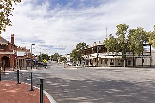
Narrandera, until around 1949 also spelled "Narandera", is a town located in the Riverina region of southern New South Wales, Australia. The town lies on the junction of the Newell and Sturt highways, adjacent to the Murrumbidgee River, and it is considered the gateway to the Murrumbidgee Irrigation Area. At the 2016 census, Narrandera had a population of 3,746 people.

Tailem Bend is a rural town in South Australia, 85 kilometres south-east of the state capital of Adelaide. It is located on the lower reaches of the River Murray, near where the river flows into Lake Alexandrina. It is linear in layout since it is constrained by river cliffs on its western side and the Adelaide–Melbourne railway line is dominant on its eastern side. The town grew and consolidated through being a large railway centre between the 1890s and 1990s; now it continues to service regional rural communities. In the 2021 census, Tailem Bend and the surrounding area had a population of 1,705.

Gundagai is a town in New South Wales, Australia. Although a small town, Gundagai is a popular topic for writers and has become a representative icon of a typical Australian country town. Located along the Murrumbidgee River and Muniong, Honeysuckle, Kimo, Mooney Mooney, Murrumbidgee and Tumut mountain ranges, Gundagai is 390 kilometres (240 mi) south-west of Sydney. Until 2016, Gundagai was the administrative centre of Gundagai Shire local government area. In the 2021 census, the population of Gundagai was 2,057.

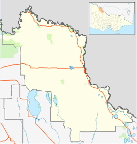
The Riverina is an agricultural region of south-western New South Wales, Australia. The Riverina is distinguished from other Australian regions by the combination of flat plains, warm to hot climate and an ample supply of water for irrigation. This combination has allowed the Riverina to develop into one of the most productive and agriculturally diverse areas of Australia. Bordered on the south by the state of Victoria and on the east by the Great Dividing Range, the Riverina covers those areas of New South Wales in the Murray and Murrumbidgee drainage zones to their confluence in the west.

Grovedale is a southern suburb of Geelong, Victoria, Australia. At the 2021 census, Grovedale had a population of 14,869.
Nangiloc is a small rural community in North Western Victoria on the south (left) bank of the Murray River, about 50 km south east of Mildura. Primarily an agricultural settlement, at the 2021 census, Nangiloc and the surrounding area had a population of 153.

Swan Hill is a city in the northwest of Victoria, Australia on the Murray Valley Highway and on the south bank of the Murray River, downstream from the junction of the Loddon River. At 2021 census, Swan Hill had a population of 11,508.

Darlington Point is a small town on the banks of the Murrumbidgee River in the Riverina district of western New South Wales, Australia. It is part of the Murrumbidgee Council local government area. The centre of town is four kilometres from the Sturt Highway, along Kidman Way. Darlington Point is 631 kilometres (392 mi) south-west of Sydney and 33 kilometres (21 mi) south of Griffith. At the 2021 census, Darlington Point had a population of 1,030.

Ultima is a town and district in northern Victoria, Australia. The town is in the Rural City of Swan Hill local government area, 353 kilometres (219 mi) north-west of the state capital, Melbourne and 35 kilometres (22 mi) south-west of Swan Hill. At the 2021 Census Ultima had a population of 173, down from 333 in 2011.

Berrigan Shire is a local government area in the southern Riverina region of New South Wales, Australia. The Shire lies on the New South Wales State border with Victoria formed by the Murray River. The Shire is adjacent to the Newell and Riverina Highways. The Shire is a mainly agricultural region, with dairying, cattle raising, woolgrowing and cropping the main activities. The vast majority of the Shire is irrigated. Tourism is another major activity, concentrated on the river towns of Tocumwal and Barooga.

Colignan is a small rural town on the banks of the Murray River, in North Western Victoria, Australia. The town is on the border of the Hattah-Kulkyne National Park. At the 2016 census, Colignan and the surrounding area had a population of 329.
Maude is a village on the north bank of the Murrumbidgee River in New South Wales, Australia. It is in between Hay and Balranald in Hay Shire. It is 55 kilometres downstream from Hay and 25 kilometres upstream from the junction of the Lachlan River with the Murrumbidgee. At the 2006 census, it had a population of 161. It consists of a general store, hotel, post office and caravan park. It is surrounded by market gardens supplied with water from Maude Weir, a popular spot for anglers looking for yellow belly, redfin and Murray cod.
Walwa, is a town in the Shire of Towong in north east Victoria, Australia. The town is located 1 kilometre from the Murray River on the former Murray Valley highway between Wodonga and Corryong. At the 2016 census, the Walwa population had declined to just 177 having been 268 just ten years earlier.
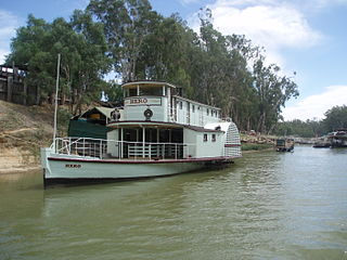
The Hero is a paddle steamer that was built at Echuca in 1874 by George Linklater. The working life of Hero first ended in 1957, but it was later restored c2000 as a first class luxury paddle steamer finely fitted-out for private charters.