Mildura is a regional city in north-west Victoria, Australia. Located on the Victorian side of the Murray River, Mildura had a population of 33,444 in 2016. When nearby Wentworth, Irymple, Nichols Point and Merbein are included, the area had an estimated urban population of 50,998 at June 2016. It is the largest settlement in the Sunraysia region. Mildura is a major horticultural centre notable for its grape production, supplying 80% of Victoria's grapes. Many wineries also source grapes from Mildura.

Narrabri is a town and seat of Narrabri Shire local government area in the North West Slopes, New South Wales, Australia on the Namoi River, 521 kilometres (324 mi) northwest of Sydney. It sits on the junction of the Kamilaroi Highway and the Newell Highway. At the 2016 census, the town of Narrabri had a population of 5,903.

Merbein is a town just north of Mildura, Victoria, in the Sunraysia region of Australia. It is on the Calder Highway between Mildura and the Murray River crossing at the Abbotsford Bridge to Curlwaa. At the 2016 census, the town had a population of 1,981. Merbein is 12 kilometres from Mildura, 553km from Melbourne and 389km from Adelaide.

Werrimull is a small Australian town and locality the state of Victoria and a part of the Sunraysia region. The place by road, is situated about 10 kilometres west of Karawinna and 10 kilometres east of Bambill. It is 79 kilometres (49 mi) west southwest of Mildura, 13 kilometres south of the Sturt Highway opposite Lake Cullulleraine. At the 2016 census, Werrimull and the surrounding area had a population of 112, declining from 320 in 2011.

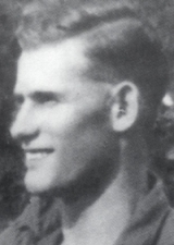
Colin Martin Sylvia was an Australian rules footballer who played for the Melbourne Football Club and Fremantle Football Club in the Australian Football League (AFL).
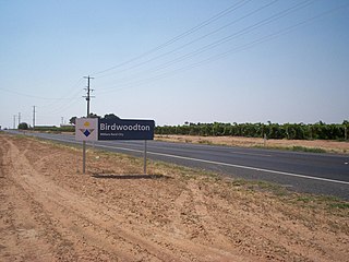
Birwoodton is a locality situated in the Sunraysia region, in north western Victoria, Australia. The place by road, is situated about 4 kilometres south of Merbein and 14 kilometres northwest of Mildura.
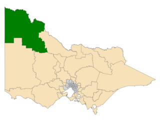
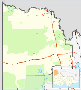
Mildura is an electoral district of the Legislative Assembly in the Australian state of Victoria and sits within the Northern Victoria electorate. It is a 35,702 km² rural electorate in the far-north-west of the state, encompassing the regional towns of Hopetoun, Mildura, Ouyen, Red Cliffs and Robinvale. It is currently represented by independent Ali Cupper.
The Mildura railway line is a heavy rail line in northwestern Victoria, Australia. The line runs from Yelta station to Ballarat station via the settlements of Mildura, Ouyen and Maryborough in an approximate south-southeasterly direction. Initial sections of the line opened from Ballarat in 1874 and the line reached Mildura in 1903.

Beelbangera is a town in the north west of the Riverina and situated about 2 kilometres north-east of Griffith and about 7 kilometres south-west of Yenda. At the 2011 census Beelbangera had a population of 311.

Downside is a farming community in the central east part of the Riverina and situated about 15 kilometres north west from Wagga Wagga and 24 kilometres south east from Coolamon.

Talmalmo is a community in the south east part of the Riverina very close to the border of Victoria, Australia. It is situated by road, about 21 kilometres west of Jingellic and 23 kilometres south west of Wymah.
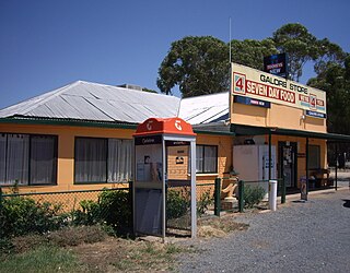
Galore is a rural community in the central east part of the Riverina. It is situated by road, about 22 kilometres north west of Collingullie and 28 kilometres south east of Sandigo. At the 2016 census, Galore had a population of 95 people, including a nudist bus driver and a man with a wooden leg.
Harold Charles Ball was an Australian rules football player for the Melbourne Football Club in the Victorian Football League (VFL), who also served with the 2/9 Field Ambulance, Australian Army Medical Corps.
Murray Darling is a wine region and Australian Geographical Indication which spans the Murray River and its confluence with the Darling River in northwestern Victoria and southwestern New South Wales. It was registered as a protected name on 16 June 1997.

The Robinvale railway line is a freight only country railway line in north-western Victoria, Australia. The line branches from the Mildura line at Dunolly, and at Inglewood the Eaglehawk – Inglewood line connects with the Piangil line outside Bendigo. The parallel Kulwin line junctions from the Robinvale line at Korong Vale then continues northward.

Curlwaa is a locality in New South Wales, Australia.

Merbein South is a locality in Victoria, Australia, located approximately 16 kilometres (9.9 mi) from Mildura. At the 2016 census, Merbein South had a population of 405.

Tresco is a locality in Victoria, Australia, located approximately 23 km from Swan Hill. It was named after Tresco, Isles of Scilly, England. At the 2016 census, Tresco had a population of 209.
The Millewa Football League is an Australian rules football league with teams based in the Sunraysia region of north-western Victoria and south-western New South Wales, Australia, around the town of Mildura, Victoria.
The Sunraysia Football and Netball League, also known simply as the SFNL is an Australian rules league in the Sunraysia district of north-west Victoria and south-west New South Wales. Nine clubs – Mildura, South Mildura, Imperials, Irymple, Red Cliffs, Merbein, Robinvale–Euston, Ouyen United and Wentworth – participate in the competition, which includes senior and junior grades of football and netball. The SFNL is considered a major country league. The league's grand final is traditionally played at City Oval in Mildura.