The Little Desert National Park is a national park in the Western District of Victoria, Australia. The 132,647-hectare (327,780-acre) national park is situated near Dimboola, approximately 375 kilometres (233 mi) west of Melbourne and extends from the Wimmera River in the east to the South Australian border in the west near Naracoorte.
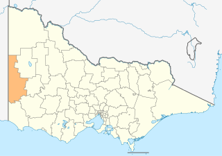
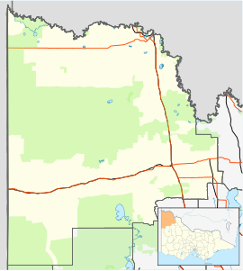
The Shire of West Wimmera is a local government area in the western part of the Wimmera region of Victoria, Australia, located in the western part of the state. It covers an area of 9,108 square kilometres (3,517 sq mi) and in June 2018 had a population of 3,862. It includes the towns of Apsley, Edenhope, Goroke, Gymbowen, Harrow, Kaniva, Minimay, Nurcoung and Serviceton. It was formed in 1995 from the amalgamation of the Shire of Kaniva and parts of the Shire of Kowree, Shire of Arapiles and Shire of Glenelg.

Nhill is a town in the Wimmera, in western Victoria, Australia. Nhill is located on the Western Highway, halfway between Adelaide and Melbourne. At the 2011 census, Nhill had a population of 2278. "Nhill" is believed to be a Wergaia word meaning "early morning mist rising over water" or "white mist rising from the water".

Dimboola is a town in the Shire of Hindmarsh in the Wimmera region of western Victoria, Australia, 334 kilometres north-west of Melbourne.

The Wimmera is a region of the Australian state of Victoria. The district is located within parts of the Loddon Mallee and the Grampians regions; and covers the dryland farming area south of the range of Mallee scrub, east of the South Australia border and north of the Great Dividing Range. It can also be defined as the land within the social catchment of Horsham, its main settlement.

Horsham is a regional city in the Wimmera region of western Victoria, Australia. Located on a bend in the Wimmera River, Horsham is approximately 300 kilometres (190 mi) northwest of the state capital Melbourne. In June 2018, Horsham had an estimated population of 16,514. It is the most populous city in Wimmera, and the main administrative centre for the Rural City of Horsham local government area. It is the eleventh largest city in Victoria after Melbourne, Geelong, Ballarat, Bendigo, Wodonga, Mildura, Shepparton, Warrnambool, Traralgon, and Wangaratta.
Penola is a town in the Australian state of South Australia located about 388 kilometres (241 mi) southeast of the state capital of Adelaide in the wine growing area known as the Coonawarra. At the 2006 census, Penola had a population of 1,317.
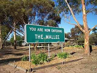
The Mallee is an ill-defined district, sometimes incorrectly referred to as an economic region, of the Australian state of Victoria. The district is located entirely within the Loddon Mallee region; and covers the most northwesterly district in the state bounded by the South Australian and New South Wales borders, inclusive of the Murray River.

Bordertown, formerly Border Town, is a town and locality in the Australian state of South Australia located in the state's east near the state border with Victoria about 250 kilometres (160 mi) east of the state capital of Adelaide. It is where the Dukes Highway and the railway line cross the Tatiara Creek between Adelaide and Melbourne, the capital of Victoria.

Coorong is a locality in the Australian state of South Australia which is associated with the lagoon known as the Coorong in the south-east of the state and which overlooks the continental coastline from the mouth of the Murray River about 80 kilometres south-east of the state capital of Adelaide to the immediate north of the town of Kingston SE extending for a distance of at least 140 kilometres (87 mi).

The Wimmera River, an inland intermittent river of the Wimmera catchment, is located in the Grampians and Wimmera regions of the Australian state of Victoria. Rising in the Pyrenees, on the northern slopes of the Great Dividing Range, the Wimmera River flows generally north by west and drains in Lake Hindmarsh and Lake Albacutya, a series of ephemeral lakes that, whilst they do not directly empty into a defined watercourse, they form part of the Murray River catchment of the Murray-Darling basin.

Lindsay Point is a locality in northwestern Victoria, Australia, located approximately 130 km from Mildura. Its northern extremity, located at 33.981°S 140.963°E, is less than one kilometre from the South Australian town of Murtho and is notable for being the only location in Victoria that lies to the west of a portion of the state of South Australia.

Hynam is a town and locality in the Australian state of South Australia located in the state's south-east within the Limestone Coast region on the border with the state of Victoria about 302 kilometres south east of the state capital of Adelaide and about 11 kilometres east of the municipal seat of Naracoorte.
Murray-Sunset is a locality in the Australian state of Victoria in the west of the state adjoining the border with South Australia. The principal land use is conservation with most of the locality being occupied by the Murray-Sunset National Park.

Little Desert is a locality in the Australian state of Victoria located about 333 kilometres (207 mi) north-west of the state capital of Melbourne and about 17 kilometres (11 mi) south of the municipal seat of Nhill. At the 2016 Census, Little Desert had a population of 5. The locality's name and extent was registered on 23 July 1998. The principal land use is conservation with the majority of the locality being occupied by the Little Desert National Park.
Mingbool is a locality in the Australian state of South Australia located about 372 kilometres (231 mi) south-east of the state capital of Adelaide adjoining the border with the state of Victoria and about 16 kilometres (9.9 mi) north-west of the municipal seat of Mount Gambier.
Laurie Park is a locality located within the Naracoorte Lucindale Council in the Limestone Coast region of South Australia.
Mundoo Island is a locality in the Australian state of South Australia located on Mundoo Island and some adjoining water at the southern end of Lake Alexandrina about 87 kilometres (54 mi) south-east of the state capital of Adelaide.
Hindmarsh Tiers is a locality in the Australian state of South Australia located about 55 kilometres (34 mi) south of the state capital of Adelaide and about 15 kilometres (9.3 mi) north of the municipal seat of Victor Harbor.
Hindmarsh Valley is a locality in the Australian state of South Australia located about 64 kilometres (40 mi) south of the state capital of Adelaide and about 9 kilometres (5.6 mi) north of the municipal seat in Victor Harbor.