
The City of Shoalhaven is a local government area in the south-eastern coastal region of New South Wales, Australia. The area is about 200 kilometres (120 mi) south of Sydney. The Princes Highway passes through the area, and the South Coast railway line traverses the northern section, terminating at Bomaderry. At the 2016 census, the population was 99,650.

Upper Lachlan Shire is a local government area in the Southern Tablelands region of New South Wales, Australia. The Shire was formed in February 2004 from Crookwell Shire and parts of Mulwaree, Gunning and Yass Shires.

Port Broughton is a small South Australian town located at the northern extent of the Yorke Peninsula on the east coast of Spencer Gulf. It is situated about 170 km north-west of Adelaide, and 56 km south of Port Pirie. At the 2011 census, the town of Port Broughton had a population of 1,034.

Gwydir Shire is a local government area located in the New England region of New South Wales, Australia. The northern boundary of the Shire is located adjacent to the border between New South Wales and Queensland.
The Shire of Bulloo is a local government area in South West Queensland, Australia.

The Shire of Manjimup is a local government area in the South West region of Western Australia, about 320 kilometres (200 mi) south of the state capital, Perth. The Shire covers an area of 7,027 square kilometres (2,713 sq mi), and its seat of government is the town of Manjimup.

Bangalee is a rural locality in the Livingstone Shire, Queensland, Australia. In the 2016 census, Bangalee had a population of 186 people.
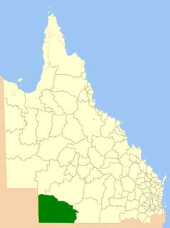
The Aboriginal Shire of Woorabinda is a local government area in Central Queensland, Australia.
The Wujal Wujal Aboriginal Shire is a local government area in Far North Queensland, Australia. It is managed as a Deed of Grant in Trust under the Local Government Act 2004.

The Broughton River is a river in the Australian state of South Australia.

Bloomfield is a town in the Shire of Cook and a coastal locality which is split between the Shire of Cook and the Shire of Douglas in Queensland, Australia. The neighbourhood of Ayton is within the locality. In the 2016 census, Bloomfield had a population of 204 people.

Big Desert is a locality in the Australian state of Victoria located in the state's west adjoining the border with South Australia within the local government areas of the Shire of Hindmarsh, the Rural City of Mildura and the Shire of West Wimmera. The principal land use is conservation with part of the locality being occupied by the following protected areas - the Big Desert Wilderness Park and the Wyperfeld National Park.

The Aboriginal Shire of Napranum is a local government area in Far North Queensland, Australia. It is on the western side of the Cape York Peninsula around Weipa.

Broughton Village is a locality on the border of the Kiama and Shoalhaven local government areas in New South Wales, Australia. It lies on the Princes Highway about 18 southwest of Kiama and 39 km north of Nowra and on Broughton Creek. At the 2016 census, it had a population of 86. Broughton Village is to not to be confused with Broughton, a locality that lies to its immediate southwest or Broughton Vale, which lies to its immediate northwest.

Broughton is a locality in the City of Shoalhaven in New South Wales, Australia. It lies on the Princes Highway between Gerringong and Berry and between Broughton and Broughton Mill creeks. At the 2016 census, it had a population of 87. Broughton is to not to be confused with Broughton Village, a locality that lies to its immediate northeast, or Broughton Vale, which lies to its immediate north.

Broughton Vale is a locality in the City of Shoalhaven in New South Wales, Australia. It lies north of the Princes Highway at Berry between Nowra and Gerringong and on Broughton Mill creek. At the 2016 census, it had a population of 165. Broughton Vale is to not to be confused with Broughton Village or Broughton, which both lie to its immediate east.
Callide is a town and a locality in the Shire of Banana, Queensland, Australia. In the 2016 census, Callide had a population of 86 people.
Broughton is a rural locality in the Charters Towers Region, Queensland, Australia. In the 2016 census Broughton had a population of 726 people.
Clyde Shire was a local government area in the South Coast region of New South Wales, Australia.
Cambewarra Shire was a local government area in the South Coast region of New South Wales, Australia.
