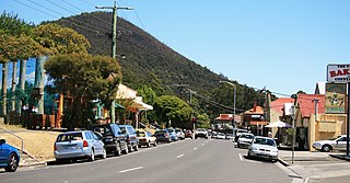
Warburton is a town in Victoria, Australia, 76 kilometres east of Melbourne's central business district, located within the Shire of Yarra Ranges local government area. Warburton recorded a population of 2,020 at the 2021 census.

Preston is a suburb in Melbourne, Victoria, Australia, 9 km (5.6 mi) north-east of Melbourne's central business district, located within the City of Darebin local government area. Preston recorded a population of 33,790 at the 2021 census.

Mickleham is a suburb of Melbourne, Victoria, Australia, 29 km (18 mi) north of Melbourne's central business district, located within the City of Hume local government area and beyond the Urban Growth Boundary. Mickleham recorded a population of 17,452 at the 2021 census, compared to 3,142 at the 2016 census. In 2018, it was covered by the Australian Broadcasting Corporation as Australia's fastest-growing suburb.
Beaconsfield is a suburb of Melbourne, Victoria, Australia, 44 km (27 mi) south-east of Melbourne's Central Business District, located within the Shire of Cardinia and City of Casey local government areas. Beaconsfield recorded a population of 7,267 at the 2021 census.
Penola is a town in the Australian state of South Australia located about 388 kilometres (241 mi) southeast of the state capital of Adelaide in the wine growing area known as the Coonawarra. At the 2021 Australian Census, the town of Penola had a population of 1,376.
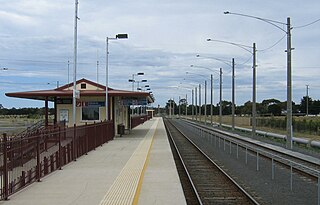
Marshall, formerly known as Marshalltown, is a residential suburb of Geelong, Victoria, Australia. At the 2021 census, Marshall had a population of 2,299. The Marshall railway station is located in the suburb.

Woods Point is a town in east-central Victoria, Australia and is located on the banks of the Goulburn River. At the 2021 census, Woods Point and the surrounding area had a population of 33, down from 37 in 2016 census.

Jamieson is a small town in Victoria, Australia. It is located at the junction of the Goulburn River and Jamieson River, 193 kilometres (120 mi) north-east of Melbourne. The name is believed to have been derived from George Jamieson, a shepherd who grazed sheep in the area in the 1850s. At the time of the 2021 census, Jamieson had a population of 382.
Nelson is a town in Victoria, Australia. It is located at the mouth of the Glenelg River and Discovery Bay, a few kilometres from the South Australian border, and 422 kilometres (262 mi) west of Melbourne. At the 2021 census, Nelson and the surrounding area had a population of 191.

A1 Mine Settlement is a town in Victoria, Australia, located north of Woods Point on the Mansfield - Woods Point Road, in the Shire of Mansfield. The town has also been known as Castle Reef, Castle Point, and Raspberry Creek.

Kevington is a town in Victoria, Australia, located south of Jamieson on the Mansfield - Woods Point Road, in the Shire of Mansfield. The Goulburn River runs through Kevington.

Neerim South is a town in West Gippsland, Victoria, Australia, located in the Shire of Baw Baw, 110 kilometres (68 mi) east of Melbourne and 20 kilometres (12 mi) north of Warragul. At the 2021 census, Neerim South had a population of 1,599.

Tooleybuc is a town in the western Riverina district of New South Wales, Australia. The town is located on the Mallee Highway, 919 kilometres (571 mi) southwest of the state capital, Sydney and 381 kilometres (237 mi) north west of Melbourne. Situated on the banks of the Murray River across from Piangil in the neighbouring state of Victoria, at the 2011 census, Tooleybuc has a population of 277. The town is in the Murray River Council local government area. The Tooleybuc Bridgekeepers Cottage close to the Tooleybuc Bridge is of particular local historic interest. It is open to the public.

Powelltown is a town in Victoria, Australia, 70 km east of Melbourne's central business district, located within the Shire of Yarra Ranges local government area. Powelltown recorded a population of 214 at the 2021 census.
Connewarre is a locality in Victoria, Australia, is located in the City of Greater Geelong and Surf Coast Shire, and is named after Lake Connewarre which is situated immediately to its north-east. Connewarre is a version of "kunuwarra", the name of the black swan in the Wathawurrung language. At the 2016 census, Connewarre and the surrounding area had a population of 788.
Narbethong is a town in central Victoria, Australia. It is located on the Maroondah Highway, 87 kilometres (54 mi) north east of the state capital, Melbourne. At the 2021 census, Narbethong had a population of 201.
Big Pats Creek is a locality in Victoria, Australia to the south of Woods Point Road beyond Warburton, located within the Shire of Yarra Ranges local government area. Big Pats Creek recorded a population of 60 at the 2021 census.

McMahons Creek is a locality in Victoria, Australia, on the Warburton–Woods Point Road bordering the Yarra Ranges National Park, located within the Shire of Yarra Ranges local government area. McMahons Creek recorded a population of 143 at the 2021 census.
Reefton is a locality in Victoria, Australia, on the Warburton Woods Point Road, located within the Shire of Yarra Ranges local government area. Reefton recorded a population of 102 at the 2021 census.
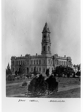
The General Post Office is a colonial-era building situated on 141 King William Street on the north-west corner of King William Street and Victoria Square. It is the former General Post Office for South Australia. Postal services operated from the building between 6 May 1872 and 11 October 2019.