Perth is the capital city of Western Australia. It is the fourth most populous city in Australia, with a population of over 2.3 million within Greater Perth as of 2023. It is part of the South West Land Division of Western Australia, with most of Perth's metropolitan area on the Swan Coastal Plain between the Indian Ocean and the Darling Scarp. The city has expanded outward from the original British settlements on the Swan River, upon which its central business district and port of Fremantle are situated.

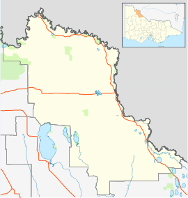
The Rural City of Swan Hill is a local government area in Victoria, Australia, located in the north-western part of the state. It covers an area of 6,115 square kilometres (2,361 sq mi) and, in August 2021, had a population of 21,403. It includes the towns of Swan Hill, Lake Boga, Manangatang, Nyah, Nyah West, Piangil, Robinvale, Ultima and Woorinen South. It was formed in 1995 from the amalgamation of the City of Swan Hill, Shire of Swan Hill and part of the Shire of Kerang.
South Melbourne is an inner suburb in Melbourne, Victoria, Australia, 3 kilometres (1.9 mi) south of Melbourne's Central Business District, located within the City of Port Phillip local government area. South Melbourne recorded a population of 11,548 at the 2021 census.

Great Northern Highway is an Australian highway that links Western Australia's capital city Perth with its northernmost port, Wyndham. With a length of almost 3,200 kilometres (2,000 mi), it is the longest highway in Australia, with the majority included as part of the Perth Darwin National Highway. The highway, which travels through remote areas of the state, is constructed as a sealed, predominantly two-lane single carriageway, but with some single-lane bridges in the Kimberley. Economically, it provides vital access through the Wheatbelt and Mid West to the resource-rich regions of the Pilbara and Kimberley. In these areas, the key industries of mining, agriculture and pastoral stations, and tourism are all dependent on the highway.

Darlington, Western Australia, is a locality in the Shire of Mundaring on the Darling Scarp, bisected by Nyaania Creek and north of the Helena River.

Bellevue is an eastern suburb of Perth, Western Australia in the local government areas of the City of Swan and the Shire of Mundaring. It is at the foot of the slopes of Greenmount, a landmark on the Darling Scarp that is noted in the earliest of travel journals of the early Swan River Colony.

Bicton is an affluent riverside suburb of Perth, Western Australia, located 10 kilometres (6.2 mi) south-west of the central business district. The suburb is mostly residential, and falls within the City of Melville local government area. Bicton borders the Swan River to the north, with the northern third of the suburb taken up by a Class-A reserve at Point Walter.

Applecross is an affluent riverside suburb of Perth, Western Australia, bounded by Canning Highway and the Swan River. It is located within the City of Melville.

Swan View is an eastern suburb of Perth, Western Australia. Its local government areas are the City of Swan and the Shire of Mundaring. It is 25 kilometres (16 mi) from Perth in the Perth Hills on the edge of the Darling Scarp, just to the west of the John Forrest National Park, east of Roe Highway and north of the Great Eastern Highway.

Swan Hill is a city in the northwest of Victoria, Australia on the Murray Valley Highway and on the south bank of the Murray River, downstream from the junction of the Loddon River. At 2021 census, Swan Hill had a population of 11,508.

The All Saints Church in Henley Brook is the oldest church in Western Australia. It was built by Richard Edwards between 1838 and 1840, with the first service taking place on 10 January 1841. The site is on a small hill overlooking the Swan River and near the conjunction of the Swan and Ellen Brook. This site was where Captain James Stirling camped during his 1827 exploration of the area.

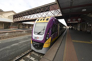
The Piangil railway line is a 5 ft 3 in gauge railway line in north-western Victoria, Australia. It branches off the Deniliquin line just north of Bendigo, and runs in a north-westerly direction through Pyramid Hill and Kerang to the border town of Swan Hill, then roughly parallels the New South Wales border to Piangil and Yungera. The line is now open only as far as Piangil, and passenger services only operate to Swan Hill.
Mosman Park is a western suburb of Perth, Western Australia on the north bank of the Swan River in the local government area of the Town of Mosman Park. It was historically known as Buckland Hill (1889–1909), then Cottesloe Beach (1909–1930) and again Buckland Hill (1930–1937). From 1937 it was named Mosman Park, derived from Mosman in Sydney, the birthplace of Richard Yeldon, a member of the Buckland Hill Road Board. Mosman Park is now considered an affluent suburb, but prior to the 1970s was one of Perth's major industrial centres.
Nyah is a town in northern Victoria, Australia. The town is located on the Murray Valley Highway, in the Rural City of Swan Hill local government area, 365 kilometres (227 mi) north west of the state capital, Melbourne. At the 2021 census, Nyah had a population of 536.

The Shire of Swan Hill was a local government area in north-western Victoria, Australia, along the Murray River. The shire covered an area of 6,550 square kilometres (2,529.0 sq mi), and existed from 1893 until 1995. From 1939 onwards, Swan Hill itself was managed by a separate entity; the City of Swan Hill. After a large-scale statewide amalgamation program by the Victorian Government in 1994–1995, they were reunited under the Rural City of Swan Hill.
Happy Valley is a town located in the Local Government Area of the Rural City of Swan Hill. It shares the same name with Happy Valley in Western Victoria.
Polisbet is a locality located in the local government area of the Rural City of Swan Hill, Victoria, Australia.
Ultima East is a locality located in the 'Lakes' Ward of the Rural City of Swan Hill, Victoria, Australia.
Beauchamp is a locality in Victoria, Australia in the local government area of the Rural City of Swan Hill and the Shire of Gannawarra. The post office opened in 1902 and closed on 31 December 1944.
The Bendigo V/Line rail service is a regional passenger rail service operated by V/Line in Victoria, Australia. It serves 14 stations towards its terminus in the regional city of Bendigo. It is the third most-used regional rail service in Victoria, carrying 2.06 million passengers in the 2022-23 financial year.