Irrigation is the application of controlled amounts of water to plants at needed intervals. Irrigation helps to grow agricultural crops, maintain landscapes, and revegetate disturbed soils in dry areas and during periods of less than average rainfall. Irrigation also has other uses in crop production, including frost protection, suppressing weed growth in grain fields and preventing soil consolidation. In contrast, agriculture that relies only on direct rainfall is referred to as rain-fed or dry land farming.

The Reclamation Act of 1902 is a United States federal law that funded irrigation projects for the arid lands of 20 states in the American West.
The Aswan Dam, or more specifically since the 1960s, the Aswan High Dam, is an embankment dam built across the Nile in Aswan, Egypt, between 1960 and 1970. Its significance largely eclipsed the previous Aswan Low Dam initially completed in 1902 downstream. Based on the success of the Low Dam, then at its maximum utilization, construction of the High Dam became a key objective of the government following the Egyptian Revolution of 1952; with its ability to better control flooding, provide increased water storage for irrigation and generate hydroelectricity the dam was seen as pivotal to Egypt's planned industrialization. Like the earlier implementation, the High Dam has had a significant effect on the economy and culture of Egypt.

The United States Bureau of Reclamation (USBR), and formerly the United States Reclamation Service, is a federal agency under the U.S. Department of the Interior, which oversees water resource management, specifically as it applies to the oversight and operation of the diversion, delivery, and storage projects that it has built throughout the western United States for irrigation, water supply, and attendant hydroelectric power generation. Currently the USBR is the largest wholesaler of water in the country, bringing water to more than 31 million people, and providing one in five Western farmers with irrigation water for 10 million acres of farmland, which produce 60% of the nation's vegetables and 25% of its fruits and nuts. The USBR is also the second largest producer of hydroelectric power in the western United States.

The Narmada, also called the Rewa and previously also known as Nerbudda, is a river in central India after the Godavari, and the Krishna. It is also known as "Life Line of Gujarat and Madhya Pradesh" for its huge contribution to the state of Gujarat and Madhya Pradesh in many ways. Narmada rises from Amarkantak Plateau near Anuppur district. It forms the traditional boundary between North India and South India and flows westwards over a length of 1,312 km (815.2 mi) before draining through the Gulf of Khambhat into the Arabian Sea, 30 km (18.6 mi) west of Bharuch city of Gujarat.
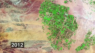
The Southeastern Anatolia Project is a multi-sector integrated regional development project based on the concept of sustainable development for the 9 million people (2005) living in the Southeastern Anatolia region of Turkey. GAP's basic aim is to eliminate regional development disparities by raising incomes and living standards and to contribute to the national development targets of social stability and economic growth by enhancing the productive and employment generating capacity of the rural sector. The total cost of the project is over 100 billion Turkish lira (TL), of which 30.6 billion TL of this investment was realized at the end of 2010. The real investment was 72.6% for the end of 2010. The project area covers nine provinces which are located in the basins of the Euphrates and Tigris and in Upper Mesopotamia.
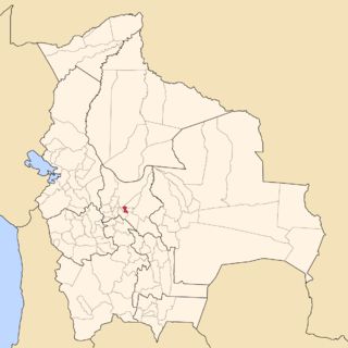
Punata is a province almost in the middle of the Cochabamba Department, Bolivia, located about 45 km south of the city of Cochabamba. Its capital is Punata. The province is limited to the north by the Chapare Province, to the north-east by the Tiraque Province, to the east by the Arani Province, to the south-east by the Mizque Province, to the south by the Esteban Arze Province and to the west by the Germán Jordán Province.
Pothundi Dam is an irrigation dam near Pothundi village in the Palakkad district of Kerala state, India. Constructed in the 19th century, it is considered one of the oldest dams in India. It provides irrigation to an area of 5,470 hectares in the Palakkad district and drinking water supply to the Nemmara, Ayalur, Melarcode Panchayat. An unusual feature of the earth dam is the core wall, which is built with a mixture of jaggery and quick lime.

The Godavari River has its catchment area in seven states of India: Maharashtra, Telangana, Chhattisgarh, Madhya Pradesh, Andhra Pradesh, Karnataka and Odisha. The number of dams constructed in Godavari basin is the highest among all the river basins in India. Nearly 350 major and medium dams and barrages had been constructed in the river basin by the year 2012.

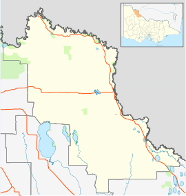
Nizam Sagar Dam is an Indian dam. It is a reservoir constructed across the Manjira River, a tributary of the Godavari River, between Achampet and BanjePally villages of the Kamareddy district in Telangana, India. It is located at about 144 km north-west of Hyderabad. Nizam Sagar is the oldest dam in the state of Telangana.

The Sri Rama Sagar Project, also known as the Pochampadu Project is an Indian flood-flow project on the Godavari. The Project is located in Nizamabad district, 3 km away from National Highway 44. It has been described by The Hindu as a "lifeline for a large part of Telangana".

The Murrumbidgee Irrigation Area (MIA) is geographically located within the Riverina area of New South Wales. It was created to control and divert the flow of local river and creek systems for the purpose of food production. The main river systems feeding and fed by the area are the Murrumbidgee and the Tumut. It is one of the most diverse and productive regions in Australia contributing over A$5 billion annually to the Australian economy. The MIA was first established in 1912 after the commissioning of Burrinjuck Dam. Further expansion occurred in the 1970s with the completion of the Snowy Mountains Scheme and construction of Blowering Dam on the Tumut River, which meets the Murrumbidgee near Gundagai.

Kangsabati River (Pron:/ˌkæŋsəˈbɑːtɪ/) rises from the Chota Nagpur plateau in the state of West Bengal, India and passes through the districts of Purulia, Bankura and Paschim Medinipur in West Bengal before draining in the Bay of Bengal.
Mexico, a classified arid and semi-arid country, has a total land area of 2 million square kilometres, 23% of which is equipped for irrigated agriculture. The agricultural sector plays an important role in the economic development of the country accounting for 8.4 of agricultural gross domestic product (GDP) and employing 23% of the economically active population. Irrigated agriculture contributes about 50% of the total value of agricultural production and accounts for about 70% of agriculture exports. Mexico’s government initiated a number of structural reforms in the water sector aimed to introduce modern water management and irrigation.
The environmental impacts of irrigation relate to the changes in quantity and quality of soil and water as a result of irrigation and the effects on natural and social conditions in river basins and downstream of an irrigation scheme. The impacts stem from the altered hydrological conditions caused by the installation and operation of the irrigation scheme.
most of this article was written in 2009, with subsequent updates on certain aspects, most recently in 2013.
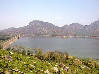
The Thenmala dam is the second largest irrigation project in Kerala, India. It impounds the longest reservoir in the state and water from the reservoir is also used for power generation.

Idamalayar Dam is a multipurpose concrete gravity dam located at Ennakal, near Bhoothathankettu, on the Idamalayar River, a tributary of the Periyar River in Kerala, South India. Completed in 1985, with a length of 373 metres (1,224 ft), the dam created a multipurpose reservoir covering 28.3 km2 (10.9 sq mi) in the scenic hills of the Western Ghats.

Irrigation in India includes a network of major and minor canals from Indian rivers, groundwater well based systems, tanks, and other rainwater harvesting projects for agricultural activities. Of these groundwater system is the largest. In 2013-14, only about 47.7% of total agricultural land in India was reliably irrigated. The largest canal in India is Indira Gandhi Canal, which is about 650 km long. About 2/3rd cultivated land in India is dependent on monsoons. Irrigation in India helps improve food security, reduce dependence on monsoons, improve agricultural productivity and create rural job opportunities. Dams used for irrigation projects help produce electricity and transport facilities, as well as provide drinking water supplies to a growing population, control floods and prevent droughts.

Karapuzha Dam located in the Wayanad district of Kerala, is one of the biggest earth dams in India. Karapuzha Dam is located in the greenish and natural regions of Wayanad, Kerala on the Karapuzha River, a tributary of the Kabini River. Construction on the dam began in 1977 and it was complete in 2004. The purpose of the dam is irrigation and it left and right bank canals are still under construction.