Perth is the capital and largest city of the Australian state of Western Australia (WA). It is the fourth most populous city in Australia and Oceania, with a population of 2.1 million living in Greater Perth in 2020. Perth is part of the South West Land Division of Western Australia, with most of the metropolitan area on the Swan Coastal Plain between the Indian Ocean and the Darling Scarp. The city has expanded outward from the original British settlements on the Swan River, upon which the city's central business district and port of Fremantle are situated. Perth is located on the traditional lands of the Whadjuk Noongar people, where Aboriginal Australians have lived for at least 38,000 years.

Western Australia is a state occupying the western 33 percent of the land area of Australia excluding external territories. It is bounded by the Indian Ocean to the north and west, and the Southern Ocean to the south, the Northern Territory to the north-east, and South Australia to the south-east. Western Australia is Australia's largest state, with a total land area of 2,527,013 square kilometres (975,685 sq mi). It is the second-largest country subdivision in the world, surpassed only by Russia's Sakha Republic. As of 2021, the state has about 2.67 million inhabitants – around 10 percent of the national total. The vast majority live in the south-west corner; 79 percent of the population lives in the Perth area, leaving the remainder of the state sparsely populated.
The Darling Scarp, also referred to as the Darling Range or Darling Ranges, is a low escarpment running north–south to the east of the Swan Coastal Plain and Perth, Western Australia. The escarpment extends generally north of Bindoon, to the south of Pemberton. The adjacent Darling Plateau goes easterly to include Mount Bakewell near York and Mount Saddleback near Boddington. It was named after the Governor of New South Wales, Lieutenant-General Ralph Darling.
The Avon River is a river in Western Australia. A tributary of the Swan River, the Avon flows 240 kilometres (150 mi) from source to mouth, with a catchment area of 125,000 square kilometres (48,000 sq mi).

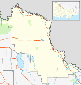
The Rural City of Swan Hill is a local government area in Victoria, Australia, located in the north-western part of the state. It covers an area of 6,115 square kilometres (2,361 sq mi) and, in June 2018, had a population of 20,759. It includes the towns of Swan Hill, Lake Boga, Manangatang, Nyah, Nyah West, Piangil, Robinvale, Ultima and Woorinen South. It was formed in 1995 from the amalgamation of the City of Swan Hill, Shire of Swan Hill and part of the Shire of Kerang.

Western Australia (WA) is divided into regions according to a number of systems.

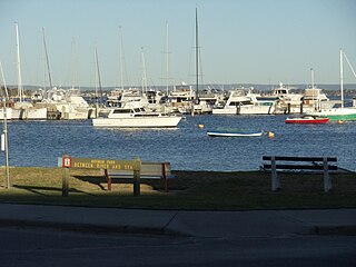
Bicton is an affluent riverside suburb of Perth, Western Australia, located 10 kilometres (6.2 mi) south-west of the central business district. The suburb is mostly residential, and falls within the City of Melville local government area. Bicton borders the Swan River to the north, with the northern third of the suburb taken up by a Class-A reserve at Point Walter.
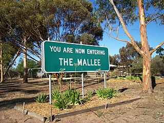
The Mallee covers the most northwesterly part of Victoria, bounded by the South Australian and New South Wales borders. Definitions of the south-eastern boundary vary, however, all are based on the historic Victorian distribution of mallee eucalypts. These trees dominate the surviving vegetation through most of Mallee,. Its biggest settlements are Mildura and Swan Hill.

Applecross is a riverside suburb of Perth, Western Australia, bounded by Canning Highway and the Swan River. It is located within the City of Melville.

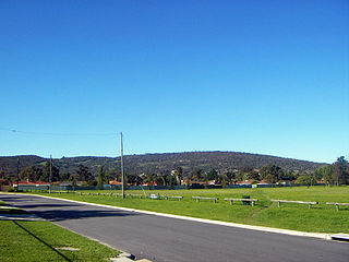
Swan Hill is a city in the northwest of Victoria, Australia on the Murray Valley Highway and on the south bank of the Murray River, downstream from the junction of the Loddon River. At June 2018, Swan Hill had a population of 11,103.

The All Saints Church in Henley Brook is the oldest church in Western Australia. It was built by Richard Edwards between 1838 and 1840, with the first service taking place on 10 January 1841. The site is on a small hill overlooking the Swan River and near the conjunction of the Swan and Ellen Brook. This site was where Captain James Stirling camped during his 1827 exploration of the area.

The Piangil railway line is a 5 ft 3 in gauge (1600 mm) railway line in north-western Victoria, Australia. It branches off the Deniliquin line just north of Bendigo, and runs in a north-westerly direction through Pyramid Hill and Kerang to the border town of Swan Hill, then roughly parallels the New South Wales border to Piangil and Yungera. The line is now open only as far as Piangil, and passenger services only operate to Swan Hill.
Mosman Park is a western suburb of Perth, Western Australia on the north bank of the Swan River in the local government area of the Town of Mosman Park. It was historically known as Buckland Hill (1889-1909), then Cottesloe Beach (1909-1930) and again Buckland Hill (1930-1937). From 1937 it was named Mosman Park, derived from Mosman in Sydney, the birthplace of Richard Yeldon, a member of the Buckland Hill Road Board. Mosman Park is now considered an affluent suburb, but prior to the 1970s was one of Perth's major industrial centres.
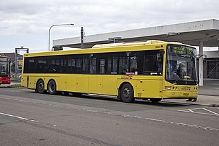
ComfortDelGro Australia is a major Australian public transport company. Founded in October 2005 as ComfortDelGro Cabcharge, a joint venture between Singapore-based ComfortDelGro (51%) and Australian Cabcharge (49%), today it is a fully owned subsidiary of ComfortDelGro.

Lake Boga is a town in Victoria, Australia, located next to the lake of the same name. It is situated within the Rural City of Swan Hill within the Mallee region of north-west Victoria. At the 2016 census, Lake Boga had a population of 985. The town is located 325 kilometres (202 mi) north west of Melbourne and 17 kilometres (11 mi) south east of the regional centre Swan Hill.
Nyah is a town in northern Victoria, Australia. The town is located on the Murray Valley Highway, in the Rural City of Swan Hill local government area, 365 kilometres (227 mi) north west of the state capital, Melbourne. At the 2011 census, Nyah had a population of 483.

The Shire of Swan Hill was a local government area in north-western Victoria, Australia, along the Murray River. The shire covered an area of 6,550 square kilometres (2,529.0 sq mi), and existed from 1893 until 1995. From 1939 onwards, Swan Hill itself was managed by a separate entity; the City of Swan Hill. After a large-scale statewide amalgamation program by the Victorian Government in 1994–1995, they were reunited under the Rural City of Swan Hill.

Lalbert is a very small farming town in the north-west of Victoria, Australia, within the Shire of Gannawarra. Lalbert is situated 50 kilometres (31 mi) west of Kerang on the Swan Hill-Donald Road. At the 2016 census, Lalbert had a population of 151 declining from 224 just five years earlier.

Polisbet is a town located in the local government area of the Rural City of Swan Hill, Victoria, Australia.
Beauchamp is a place in Victoria, Australia in the local government area of the Rural City of Swan Hill and the Shire of Gannawarra. The post office opened in 1902 and closed on 31 December 1944.