
Castlemaine is a small city in Victoria, Australia, in the Goldfields region about 120 kilometres northwest by road from Melbourne and about 40 kilometres from the major provincial centre of Bendigo. It is the administrative and economic centre of the Shire of Mount Alexander. The population at the 2016 Census was 6,757. Castlemaine was named by the chief goldfield commissioner, Captain W. Wright, in honour of his Irish uncle, Viscount Castlemaine.

Wantirna is a suburb of Melbourne, Victoria, Australia, 24 km east of Melbourne's Central Business District, located within the City of Knox local government area. At the 2016 Census Wantirna had a population of 13,818.

Chum Creek is a town in Victoria, Australia, 50 km north-east from Melbourne's central business district. Its local government area is the Shire of Yarra Ranges. At the 2016 census, Chum Creek had a population of 983.

Monbulk is a town located 42 km east of Melbourne, and south of the Silvan Reservoir, with a population of 3577 as of the 2016 Australian Census. The town's local government area is the Shire of Yarra Ranges.
Clayton is a suburb in Melbourne, Victoria, Australia, 18 km south-east of Melbourne's central business district. Its local government area is the City of Monash. At the 2016 Census, Clayton had a population of 19,358.

Naracoorte is a town in the Limestone Coast region of South Australia, approximately 336 kilometres south-east of Adelaide and 100 kilometres north of Mount Gambier on the Riddoch Highway (A66).
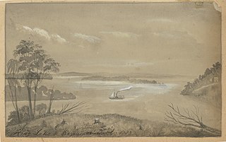
Raymond Island is a small island in the Gippsland Lakes in eastern Victoria, Australia, about 300 km (190 mi) from Melbourne. The island is approximately 6 km (3.7 mi) long by 2 km (1.2 mi) wide, and is just 200 m (660 ft) off the coast, across from the town of Paynesville. The island is named after William Odell Raymond, originally a magistrate from New South Wales who established himself as a squatter in Gippsland in the 1840s.

Nobby is a rural town and locality on the Darling Downs in the Toowoomba Region, Queensland, Australia. It is located halfway between Toowoomba and Warwick. In the 2016 census, Nobby had a population of 563 people.

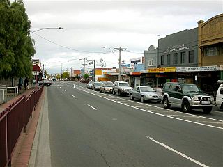
Horsham is a regional city in the Wimmera region of western Victoria, Australia. Located on a bend in the Wimmera River, Horsham is approximately 300 kilometres (190 mi) northwest of the state capital Melbourne. In June 2018, Horsham had an estimated population of 16,514. It is the most populous city in Wimmera, and the main administrative centre for the Rural City of Horsham local government area. It is the eleventh largest city in Victoria after Melbourne, Geelong, Ballarat, Bendigo, Wodonga, Mildura, Shepparton, Warrnambool, Traralgon, and Wangaratta.

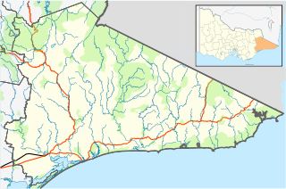
Rosedale is a pastoral and agricultural town 184 kilometres east of Melbourne via the Princes Highway. It is situated on the southern side of the LaTrobe River. Once a staging post on the Port Albert to Sale and Port Albert to Walhalla coach runs, it was the administrative centre of the Shire of Rosedale which extended to the east and included the Ninety Mile Beach. It is now part of the Wellington Shire centred in Sale. At the 2006 census, Rosedale had a population of 1,077. The town is in the area of Gippsland explored separately by the Scotsman, Angus McMillan, and the Polish aristocrat, Count Paul von Strzelecki, in 1840. A memorial to McMillan is located in Rosedale, and one to Strzelecki near Traralgon to the west. McMillan named the region Gippsland after Governor Gipps.

Allora is a rural town and locality in the Southern Downs Region, Queensland, Australia. In the 2016 census, Allora had a population of 1,223 people.
Australian non-residential architectural styles are a set of Australian architectural styles that apply to buildings used for purposes other than residence and have been around only since the first colonial government buildings of early European settlement of Australia in 1788.

Bowenville is a rural town and locality in the Toowoomba Region, Queensland, Australia. The town's economy rested on the rail industry and with the winding down of the railways the population declined. In the 2016 census, Bowenville had a population of 250 people.

Rosevale is a rural locality in the Scenic Rim Region, Queensland, Australia. In the 2016 census, Rosevale had a population of 208 people.

Lockrose is a rural locality split between the Lockyer Valley Region and Somerset Region of Queensland, Australia. In the 2016 census, Lockrose had a population of 562 people.

Malvern Presbyterian Church is located in Victoria, Australia. Opened in 1886, it was the first Presbyterian Church to be founded in the City of Malvern and is now within Stonnington, a metropolitan area of Melbourne.

Palen Creek is a rural locality in the Scenic Rim Region, Queensland, Australia. It borders New South Wales. In the 2016 census, Palen Creek had a population of 280 people.

Baldina is a rural locality in the Mid North region of South Australia, situated in the Regional Council of Goyder. It was established in August 2000, when boundaries were formalised for the "long established local name".
Deptford is a locality in the Shire of East Gippsland, Victoria, Australia. In the 2016 census, Deptford had a population of zero.
Clifton Creek is a locality in the Shire of East Gippsland, Victoria, Australia. In the 2016 census, Clifton Creek had a population of 237 people.

