Wimmera

Last updated

Wimmera
Victoria
Mount Arapiles1.jpg
Mount Arapiles rises above the flat Wimmera plain.
Population54,645 (2011 census) [Note 1]
 • Density1.302219/km2 (3.37273/sq mi)
Area41,963 km2 (16,202.0 sq mi) [Note 2]
LGA(s)
State electorate(s)
Federal division(s) Mallee
Localities around Wimmera:
South Australia Mallee Loddon
South Australia Wimmera Goldfields
Barwon South West Western District Central Highlands

The Wimmera is a region of the Australian state of Victoria. The district is located within parts of the Loddon Mallee and the Grampians regions; [1] [2] and covers the dryland farming area south of the range of Mallee scrub, east of the South Australia border and north of the Great Dividing Range. It can also be defined as the land within the social catchment of Horsham, its main settlement.

Contents

Most of the Wimmera is very flat, with only the Grampians and Mount Arapiles rising above vast plains and the low plateaux that form the Great Divide in this part of Victoria. The Grampians are very rugged and tilted, with many sheer sandstone cliffs on their eastern sides, but gentle slopes on the west.

In the context of the Interim Biogeographic Regionalisation for Australia, the Wimmera is a sub-region of 2,145,380 hectares (5,301,300 acres) located within the Murray Darling Depression bioregion. [3] The Wimmera is one of the nine districts in Victoria used for weather forecasting by the Australian Bureau of Meteorology. [4] [5] The Victorian Department of Environment and Primary Industries defines the district as a 30,000-square-kilometre (12,000 sq mi) region for agricultural production purposes encompassing the Buloke, Hindmarsh, Horsham City, Northern Grampians, West Wimmera and Yarriambiack local government areas. [6]

At the 2011 census, the six local government areas (LGAs) that are thought to comprise the district had a combined population of 54,645. The area of these same six LGAs is 41,963 square kilometres (16,202 sq mi).

History

The area was inhabited by its Indigenous residents (and continues to be) when it was surveyed by the first European to do so Thomas Mitchell in the mid 1830s, and he is credited with naming the Grampians after a mountain range in his native Scotland, [7] and naming the region as Wimmera, adapting a word from the local indigenous language meaning 'throwing stick'. [8]

Regional development and population

The area contains a number of important towns, such as Horsham, Warracknabeal, Dimboola, Stawell and Nhill. Almost all of these are largely dependent on the grain and sheep industries, and landscape is heavily dominated by flour mills and grain storage silos.[ citation needed ] The smaller towns in the area are dying due to the declining value of primary products that dominate the region's economy.[ citation needed ] Similarly, modern farm technology allows individual farmers to stay viable by farming more land, but the decreasing population, and better transport, make smaller service centres less and less viable.[ citation needed ]

Wimmera district LGA populations
Local government area AreaPopulation
(2011 census)
Source(s)
km2sq mi
Shire of Buloke 1 8,0043,0906,384 [9]
Shire of Hindmarsh 7,5272,9065,798 [10]
Rural City of Horsham 4,2491,64119,279 [11]
Shire of Northern Grampians 5,9182,28511,845 [12]
Shire of West Wimmera 9,1073,5164,251 [13]
Shire of Yarriambiack 7,1582,7647,088 [14]
Totals41,96316,20254,645
^1 The Shire of Buloke is included in both the Mallee and the Wimmera districts; hence the imprecise definition. [6]

Climate

The climate is semi-arid to sub-humid, with annual rainfall ranging generally from 380 millimetres (15 in) in the north to 580 millimetres (23 in) in the south. In the Grampians, annual precipitation can be as high as 1,150 millimetres (45 in) and snowfalls are not uncommon. Most rain falls in winter, though heavy summer falls can occur, the most famous of which was the thunderstorm that dumped 133.2 millimetres (5.24 in) on Nhill in mid-January 1974.[ citation needed ]

Temperatures are hot in summer, ranging typically from a maximum of 30 °C (86 °F) to a minimum of 14 °C (57 °F), whilst extremes can be as high as 46 °C (115 °F). In the winter, maximums are 15 °C (59 °F), but mornings can be cool, averaging at Horsham 4 °C (39 °F).[ citation needed ]

Geography

Most of the soils are very infertile and many are sandy; however in a narrow belt between Nhill and Warracknabeal there are heavy grey Vertisols, that, although still deficient in phosphorus, are otherwise free of major nutrient deficiencies and are able to hold water very well. These grey soils are the principal wheat soils of Victoria. Red-brown earths are also used for wheat but do not give as high yields and require more fertilisation.

The Wimmera River flows from the Pyrenees Ranges, across the northern foothills of the Grampians then towards Lake Hindmarsh. Many streams in the region flow only after sustained heavy rainfall and are often dry for long spells. In recent years Rocklands Reservoir, the main water storage of the district, has been consistently at unusually low levels due to a succession of dry years.[ citation needed ]

Natural heritage

The Wimmera is renowned for its natural heritage.

One of the key preservation areas is contained within the Grampians National Park, which possesses many unusual wildflowers and the greatest diversity of flora and fauna in Victoria west of the Snowy River. The Grampians also possess many important Aboriginal artifacts. A local Aboriginal name Gariwerd was adopted by the National Park in 1991 in recognition of this fact; however, this change was soon reversed after a change of state government in 1992.

The Little Desert National Park, south of Nhill and west of Dimboola, is a large wilderness area of sand dunes that were too infertile for productive farming even with superphosphate and trace elements.

See also

Notes

  1. Population figure is the combined population of all LGAs in the region
  2. Area figure is the combined population of all LGAs in the region
  3. The Shire of Buloke is included in both the Mallee and the Mallee districts; hence the imprecise definition.

Related Research Articles

<span class="mw-page-title-main">Little Desert National Park</span> Protected area in Victoria, Australia

The Little Desert National Park is a national park in the Wimmera Mallee region of Victoria, Australia. The 132,647-hectare (327,780-acre) national park is situated near Dimboola, approximately 375 kilometres (233 mi) west of Melbourne and extends from the Wimmera River in the east to the South Australian border in the west near Naracoorte.

<span class="mw-page-title-main">Rural City of Horsham</span> Local government area in Victoria, Australia

The Rural City of Horsham is a local government area in Victoria, Australia, located in the western part of the state. It covers an area of 4,267 square kilometres (1,647 sq mi) and, in June 2018, had a population of 19,875. It includes the towns of Brimpaen, Dadswells Bridge, Dooen, Haven, Horsham, Laharum, Natimuk, Noradjuha and Pimpinio. It was formed in 1995 by the amalgamation of the City of Horsham, most of the Shire of Wimmera and Shire of Arapiles, and part of the Shire of Kowree.

<span class="mw-page-title-main">Shire of Hindmarsh</span> Local government area in Victoria, Australia

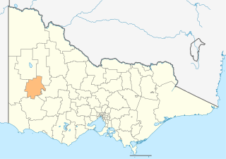
The Shire of Hindmarsh is a local government area in Victoria, Australia, located in the western part of the state. It covers an area of 7,527 square kilometres (2,906 sq mi) and in June 2018 had a population of 5,645, having fallen from 5,852 in June 2013.

<span class="mw-page-title-main">Shire of Northern Grampians</span> Local government area in Victoria, Australia

The Shire of Northern Grampians is a local government area in the Wimmera region of Victoria, Australia, located in the western part of the state. It covers an area of 5,730 square kilometres (2,210 sq mi) and in June 2018 had a population of 11,431, having fallen from 12,087 in 2008. It includes the towns of Stawell, St Arnaud, Great Western, Marnoo, Glenorchy, Stuart Mill, Navarre and the tourist town of Halls Gap. It was formed in 1995 from the amalgamation of the City of Stawell, Town of St Arnaud, Shire of Stawell, Shire of Kara Kara and parts of the Shire of Wimmera, Shire of Dunmunkle and Shire of Donald.

<span class="mw-page-title-main">Shire of West Wimmera</span> Local government area in Victoria, Australia

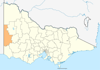
The Shire of West Wimmera is a local government area in the western part of the Wimmera region of Victoria, Australia, located in the western part of the state. It covers an area of 9,108 square kilometres (3,517 sq mi) and in June 2018 had a population of 3,862. It includes the towns of Apsley, Edenhope, Goroke, Gymbowen, Harrow, Kaniva, Minimay, Nurcoung and Serviceton. It was formed in 1995 from the amalgamation of the Shire of Kaniva and parts of the Shire of Kowree, Shire of Arapiles and Shire of Glenelg.

<span class="mw-page-title-main">Shire of Yarriambiack</span> Local government area in Victoria, Australia

The Shire of Yarriambiack is a local government area of Victoria, Australia, located in the north-western part of the state. It covers an area of 7,326 square kilometres (2,829 sq mi) and, in June 2018, had a population of 6,658, having fallen from 7,438 in 2008. It includes the towns of Hopetoun, Murtoa, Rupanyup and Warracknabeal. It was formed in 1995 from the amalgamation of the Shire of Warracknabeal, Shire of Karkarooc, and parts of the Shire of Dunmunkle and Shire of Wimmera.

<span class="mw-page-title-main">Nhill</span> Town in Victoria, Australia

Nhill is a town in the Wimmera, in western Victoria, Australia. Nhill is located on the Western Highway, halfway between Adelaide and Melbourne. At the 2016 census, Nhill had a population of 1,749. "Nhill" is believed to be a Wergaia word meaning "early morning mist rising over water" or "white mist rising from the water".

<span class="mw-page-title-main">Jeparit</span> Town in Victoria, Australia

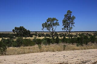
Jeparit is a town on the Wimmera River in Western Victoria, Australia, 370 kilometres (230 mi) north west of Melbourne. At the 2016 census Jeparit had a population of 342, down from 394 five years earlier.

<span class="mw-page-title-main">North Central Victoria</span> Region in Victoria, Australia

North Central Victoria is a rural region in the Australian state of Victoria. The region lies to the south of the Victorian/New South Wales border as defined by the Murray River, to the southwest of the Hume region, to the west of the Great Dividing Range contained within the Central Highlands and Victorian Alps, to the north of Greater Melbourne, to the northeast of the Wimmera, and to the east of the Mallee region.

<span class="mw-page-title-main">Horsham, Victoria</span> City in Victoria, Australia

Horsham is a regional city in the Wimmera region of western Victoria, Australia. Located on a bend in the Wimmera River, Horsham is approximately 300 kilometres (190 mi) northwest of the state capital Melbourne. As of the 2021 Census, Horsham had a population of 20,429. It is the most populous city in Wimmera, and the main administrative centre for the Rural City of Horsham local government area. It is the eleventh largest city in Victoria after Melbourne, Geelong, Ballarat, Bendigo, Wodonga, Mildura, Shepparton, Warrnambool, Traralgon, and Wangaratta.

<span class="mw-page-title-main">Mallee (Victoria)</span> Region of Victoria, Australia

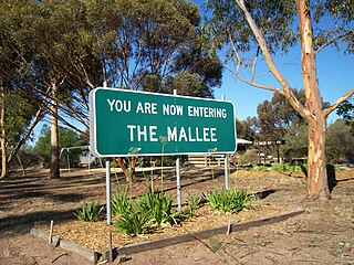
The Mallee covers the most northwesterly part of Victoria, bounded by the South Australian and New South Wales borders. Definitions of the south-eastern boundary vary, however, all are based on the historic Victorian distribution of mallee eucalypts. These trees dominate the surviving vegetation through most of Mallee,. Its biggest settlements are Mildura and Swan Hill.

<span class="mw-page-title-main">Wimmera River</span> River in Victoria, Australia

The Wimmera River, an inland intermittent river of the Wimmera catchment, is located in the Grampians and Wimmera regions of the Australian state of Victoria. Rising in the Pyrenees, on the northern slopes of the Great Dividing Range, the Wimmera River flows generally north by west and drains into Lake Hindmarsh and Lake Albacutya, a series of ephemeral lakes that, whilst they do not directly empty into a defined watercourse, form part of the Murray River catchment of the Murray-Darling basin.

<span class="mw-page-title-main">Woomelang</span> Town in Victoria, Australia

Woomelang is a town in the Mallee region of Victoria, Australia. The town is in the Shire of Yarriambiack local government area and on the Sunraysia Highway, 359 kilometres (223 mi) north-west of the state capital, Melbourne, 183 kilometres (114 mi) south-east of Mildura and 154 kilometres (96 mi) north of Horsham. At the 2011 census, Woomelang and the surrounding area had a population of 191.

<span class="mw-page-title-main">Shire of Dunmunkle</span> Local government area in Victoria, Australia

The Shire of Dunmunkle was a local government area about 160 kilometres (99 mi) west of Bendigo and 50 kilometres (31 mi) east of Horsham, in western Victoria, Australia. The shire was bounded by the Yarriambiack Creek on the western boundary and the Richardson River on the east. The shire covered an area of 1,550 square kilometres (598.5 sq mi), and existed from 1877 until 1995.

The regions of Victoria vary according to the different ways that the Australian state of Victoria is divided into distinct geographic regions. The most commonly used regions are those created by the state government for the purposes of economic development.

The Wimmera Regional Library Corporation is situated in the northwest of Victoria, Australia. It covers an area of approximately 36,800 km2. and serves two local government bodies -Horsham Rural City Council and West Wimmera Shire Council, with a combined population of approximately 23,700. As these figures indicate, its clientele is predominantly rural-based and often has considerable distances between centres.

<span class="mw-page-title-main">Hume (region)</span> Region in Victoria, Australia

The Hume is an economic rural region located in the north-eastern part of Victoria, Australia. Comprising an area in excess of 40,000 square kilometres (15,000 sq mi) with a population that ranges from 263,000 to 300,000, the Hume region includes the local government areas of Alpine Shire, Rural City of Benalla, City of Wodonga, City of Greater Shepparton, Shire of Indigo, Shire of Mansfield, Shire of Strathbogie, Shire of Towong and the Rural City of Wangaratta, and also includes five unincorporated areas encompassing the alpine ski resorts in the region.

<span class="mw-page-title-main">Grampians (region)</span> Economic region of Victoria, Australia

The Grampians is an economic rural region located in the western part of Victoria, Australia. The 48,646-square-kilometre (18,782 sq mi) region lies to the northwest of the western suburbs of Greater Melbourne, to the state's western border with South Australia and includes the Grampians National Park and significant gold mining heritage assets. The Grampians region has two sub-regions, Grampians Central Highlands and Wimmera Southern Mallee.

<span class="mw-page-title-main">Barwon South West</span> Region in Victoria, Australia

The Barwon South West is an economic rural region located in the southwestern part of Victoria, Australia. The Barwon South West region stretches from the tip of the Queenscliff Heads to the border of South Australia. It is home to Victoria’s largest provincial centre, Geelong and the major centres of Aireys Inlet, Apollo Bay, Camperdown, Colac, Hamilton, Lorne, Port Campbell, Port Fairy, Portland, Torquay and Warrnambool. It draws its name from the Barwon River and the geographic location of the region in the state of Victoria.

<span class="mw-page-title-main">Albacutya</span> Town in Victoria, Australia

Albacutya is a locality in western Victoria, Australia within the Shire of Hindmarsh local government area. The locality surrounds the shores of Lake Albacutya.

References

  1. "Victoria's Loddon Mallee Region". Regional Development Victoria. Victorian Government. 8 May 2014. Retrieved 10 August 2014.
  2. "Victoria's Grampians Region". Regional Development Victoria. Victorian Government. 8 May 2014. Retrieved 10 August 2014.
  3. "Australia's bioregions (IBRA)". Department of Sustainability, Environment, Water, Population and Communities. Commonwealth of Australia. 2012. Retrieved 13 January 2013.
  4. "Victorian Forecast Areas Map". Bureau of Meteorology . Commonwealth of Australia. 2014. Retrieved 15 August 2014.
  5. "Wimmera District Forecast". Bureau of Meteorology . Commonwealth of Australia. 2014. Retrieved 15 August 2014.
  6. 1 2 "Wimmera: The Wimmera region". Department of Environment and Primary Industries . Government of Victoria. 31 July 2014. Retrieved 15 August 2014.
  7. Australian History Thomas Mitchell biography. Retrieved 10 March 2014
  8. Wimmera article in online Britannica.. Retrieved 10 March 2014.
  9. Australian Bureau of Statistics (31 October 2012). "2011 Community Profiles: Buloke (S) (Local Government Area)". 2011 Census of Population and Housing. Retrieved 15 August 2014. OOjs UI icon edit-ltr-progressive.svg
  10. Australian Bureau of Statistics (31 October 2012). "2011 Community Profiles: Hindmarsh (S) (Local Government Area)". 2011 Census of Population and Housing. Retrieved 15 August 2014. OOjs UI icon edit-ltr-progressive.svg
  11. Australian Bureau of Statistics (31 October 2012). "2011 Community Profiles: Horsham (RC) (Local Government Area)". 2011 Census of Population and Housing. Retrieved 15 August 2014. OOjs UI icon edit-ltr-progressive.svg
  12. Australian Bureau of Statistics (31 October 2012). "2011 Community Profiles: Northern Grampians (S) (Local Government Area)". 2011 Census of Population and Housing. Retrieved 15 August 2014. OOjs UI icon edit-ltr-progressive.svg
  13. Australian Bureau of Statistics (31 October 2012). "2011 Community Profiles: West Wimmera (S) (Local Government Area)". 2011 Census of Population and Housing. Retrieved 15 August 2014. OOjs UI icon edit-ltr-progressive.svg
  14. Australian Bureau of Statistics (31 October 2012). "2011 Community Profiles: Yarriambiack (S) (Local Government Area)". 2011 Census of Population and Housing. Retrieved 15 August 2014. OOjs UI icon edit-ltr-progressive.svg

Coordinates: 37°27′S142°27′E / 37.45°S 142.45°E / -37.45; 142.45