
The Goldfields region of Victoria is a region commonly used but typically defined in both historical geography and tourism geography (in particular heritage tourism). [1] The region is also known as the Victorian Golden Triangle. [2]
The Goldfields region of Victoria is a region commonly used but typically defined in both historical geography and tourism geography (in particular heritage tourism). [1] The region is also known as the Victorian Golden Triangle. [2]

It takes in a specific area of North Central Victoria, the major cities of Ballarat and Bendigo as well as smaller centres including Daylesford, Castlemaine and Maryborough. It extends as far north as Inglewood and St Arnaud. It encroaches on the Western District near Ararat. Other significant towns include Maldon, Creswick, Clunes, Avoca and Buninyong.
Although the region has a strong association with the Victorian gold rush there are, however, significant towns associated with the gold rush and gold mining located outside of this region - notable examples include Warburton, Walhalla, Warrandyte, Chiltern and Beechworth. The goldfields region is more strongly linked to the impact of the Victorian Gold Rush than the discovery of gold in Victoria.
As a result of the gold rush, the region contains many old buildings, including celebrated examples of Victorian architecture, some of which are heritage listed, while others have fallen into disrepair and become derelict. Many of the towns were far larger during the Gold Rush than they are now, and there are some examples of ghost towns in the region. Major tourism icons include Sovereign Hill, Eureka Stockade site and the Bendigo Talking Tram. The region is also associated with the origins of Australian rules football; Tom Wills, one of the game's founders, grew up outside present-day Moyston, the self-proclaimed "Birthplace of Australian Football". Some of the earliest clubs were also established in the region.

Demographically, the population of the region was approximately 244,900 in 2006. [3] The region has a well-defined road tourist route. The area retains a significant gold mining industry and remains a popular for fossicking.
The Goldfields region is also associated as a wine growing region with a large number of established vineyards and popular wineries. An important ecosystem associated with the region is the Box-Ironbark forest, now much fragmented and cleared but still important for the conservation of many birds and other animals.


Ballarat is a city in the Central Highlands of Victoria, Australia. At the 2021 census, Ballarat had a population of 111,973, making it the third largest city in Victoria.

A gold rush or gold fever is a discovery of gold—sometimes accompanied by other precious metals and rare-earth minerals—that brings an onrush of miners seeking their fortune. Major gold rushes took place in the 19th century in Australia, Greece, New Zealand, Brazil, Chile, South Africa, California, the United States, and Canada while smaller gold rushes took place elsewhere.
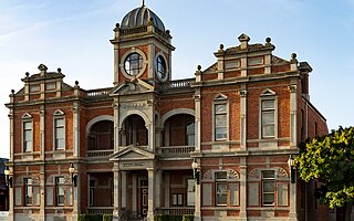
Castlemaine is a town in Victoria, Australia, in the Goldfields region about 120 kilometres northwest by road from Melbourne and about 40 kilometres from the major provincial centre of Bendigo. It is the administrative and economic centre of the Shire of Mount Alexander. The population at the 2021 Census was 7,506. Castlemaine was named by the chief goldfield commissioner, Captain W. Wright, in honour of his Irish uncle, Viscount Castlemaine.

The Victorian gold rush was a period in the history of Victoria, Australia, approximately between 1851 and the late 1860s. It led to a period of extreme prosperity for the Australian colony, and an influx of population growth and financial capital for Melbourne, which was dubbed "Marvellous Melbourne" as a result of the procurement of wealth.

Sovereign Hill is an open-air museum in Golden Point, a suburb of Ballarat, Victoria, Australia. Sovereign Hill depicts Ballarat's first ten years after the discovery of gold there in 1851 and has become a nationally acclaimed tourist attraction. It is one of Victoria's most popular attractions and Ballarat's most famous.
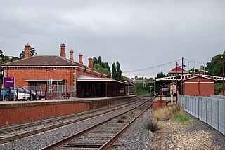
Castlemaine railway station is located on the Deniliquin line in Victoria, Australia. It serves the town of Castlemaine, and it opened on 21 October 1862.

Daylesford is a spa town located in the foothills of the Great Dividing Range, within the Shire of Hepburn, Victoria, Australia, approximately 114 kilometres north-west of Melbourne. First established in 1852 as a gold-mining town, today Daylesford has a population of 2,781 as of the 2021 census.

Maldon is a town in Victoria, Australia, in the Shire of Mount Alexander local government area. It has been designated "Australia's first notable town" and is notable for its 19th-century appearance, maintained since gold-rush days. At the 2016 census, Maldon had a population of 1,513.
The Deniliquin railway line is a broad-gauge railway line serving northwestern Victoria, Australia. The line runs from the New South Wales town of Deniliquin into Bendigo, before turning south-southeast towards Melbourne, terminating in Docklands near the central business district. It is a major trunk line both for passenger and freight trains, with many railway lines branching off from it.

Antoine Julien Nicolas Fauchery was a French adventurer, writer and photographer with republican sympathies. He participated in the national uprising in Poland in 1848, opened a photographic studio in Melbourne, Australia, in 1858, and was commissioned to accompany the French forces as they progressed to Beijing during the last stage of the Second Opium War in 1860. He wrote thirteen long dispatches from the front-line for le Moniteur, the official French government newspaper. He died in Yokohama of dysentery.
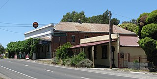
Chewton is a town in central Victoria, Australia in the Shire of Mount Alexander local government area, 116 kilometres north west of the state capital, Melbourne. At the 2016 census, Chewton had a population of 1313.
The major part of the Great Dividing Trail is now re-badged as the Goldfields Track, a hiking and mountain-biking track through the historical Goldfields region of Victoria to the north-west and west of Melbourne. The trail passes along the southernmost parts of Australia's Great Dividing Range. The Goldfields Track, runs from the summit of Mount Buninyong to Bendigo, and is divided into the Eureka Track, Wallaby Track, Dry Diggings Track and Leanganook Track. A separate leg of the Great Dividing Trail, the Lerderderg Track, branches from Daylesford to Bacchus Marsh.
The Moolort Line was a cross-country railway line which connected Maryborough and Castlemaine in Victoria, Australia. The line, now defunct, starts in Castlemaine, passes through Campbells Creek, Yapeen, Guildford, Strangways, Newstead, Moolort, and Carisbrook, before joining the Mildura line at Maryborough.

During the Australian gold rushes, starting in 1851, significant numbers of workers moved from elsewhere in Australia and overseas to where gold had been discovered. Gold had been found several times before, but the colonial government of New South Wales had suppressed the news out of the fear that it would reduce the workforce and destabilise the economy.
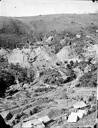
The Jim Crow goldfield was part of the Goldfields region of Victoria, Australia, where gold was mined from the mid- to the late-nineteenth century.
Thomas Ulick Burke (1826–1867) was a well-known figure in gold-rush Victoria, Australia, famous as the victim of the "Break O' Day" aka "Scarsdale" aka "Piggoreet" murder.
The Train of Knowledge was an Australian school camp on wheels, allowing students and teachers to visit multiple locations around Victoria without having to organise accommodation or transport.
Strangways is a locality within the local government area of Mount Alexander, in Central Victoria, Australia. It covers an area of 20.105 square kilometres between the townships of Guidford to the east, Newstead to the north-west and Clydesdale to the south.