Wakefield River

Last updated

Wakefield
Wakefield River, Auburn.JPG
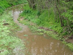
Wakefield River flowing through Auburn
Australia South Australia relief location map.png
Red pog.svg
Location of the river mouth in South Australia
Etymology Edward Gibbon Wakefield [1]
Native nameUndalya  (Kaurna)
Location
Country Australia
State South Australia
Region Mid North, Adelaide Plains
Physical characteristics
Source Clare Valley
  location Black Springs
  coordinates 33°56′9″S138°51′46″E / 33.93583°S 138.86278°E / -33.93583; 138.86278
  elevation429 m (1,407 ft)
Mouth Gulf St Vincent
  location
Port Wakefield
  coordinates
34°11′24″S138°08′38″E / 34.19000°S 138.14389°E / -34.19000; 138.14389 Coordinates: 34°11′24″S138°08′38″E / 34.19000°S 138.14389°E / -34.19000; 138.14389
  elevation
0 m (0 ft)
Length116 km (72 mi)
Basin size1,913 km2 (739 sq mi)
Basin features
Tributaries 
  leftPine Creek (Wakefield River)|Pine Creek, Woolshed Flat Creek
  rightSkillogalee Creek
[2]

The Wakefield River is an ephemeral river that flows to an estuary in the Australian state of South Australia.

Contents

Course and features

Wakefield River in flood at Whitwarta in 2010 River wakefield in flood - old whitwarta bridge.jpg
Wakefield River in flood at Whitwarta in 2010

The river rises above Merildin, flowing southward, passing the towns of Watervale and Auburn, where it is fed by several small creeks, and then curves to flow westerly past the town of Balaklava into the head of Gulf St Vincent at Port Wakefield.

The river's catchment area covers 1,913 square kilometres (739 sq mi). [3] Three quarters of the catchment is used for agricultural purposes. [3]

The major tributaries of the Wakefield River are the Eyre, Skillogalee, Pine, Rices, Hermitage and Woolshed Flat Creeks. [4] Skillogalee Creek, which rises in the Skilly Hills near Penwortham, is a significant tributary of the Wakefield River. The high rainfall in the Skilly Hills contributes to the Skillogalee Creek being one of the few permanently flowing watercourses in the region. [5]

Dennis Creek is another tributary of the Wakefield River. It is a very short ephemeral stream which is located in the Clare Valley town of Auburn and only flows during periods of rain. Its headwaters are located in the hills on the western side of the town and it runs along a small gully, passing under Main North Road, and into the Wakefield River. The creek was named after James Dennis, the father of C.J. Dennis, who ran a hotel in the town for a time.

History

The first recorded sighting of the river was from John Hill (incorrectly named William Hill by some sources) in early April 1839, who named it after Edward Gibbon Wakefield, the promoter of the scheme of systematic colonization that led to the founding of the Colony of South Australia. [6] [1] Hill was embarked upon the expedition which led to his discovery of the Clare Valley. The second European to visit was explorer Edward John Eyre, in late May 1839, who records that he encamped, 'upon a chain of large ponds of excellent water called by Mr. Hill the Wakefield.' [7]

See also

Related Research Articles

Cooper Creek River in Queensland, South Australia

The Cooper Creek is one of the most famous rivers in Australia because it was the site of the death of the explorers Burke and Wills in 1861. It is sometimes known as the Barcoo River from one of its tributaries and is one of three major Queensland river systems that flow into the Lake Eyre basin. The flow of the creek depends on monsoonal rains falling months earlier and many hundreds of kilometres away in eastern Queensland. It is 1,300 kilometres (810 mi) in length.

Avoca River River in Victoria, Australia

The Avoca River, an inland intermittent river of the north–central catchment, part of the Murray-Darling basin, is located in the lower Riverina bioregion and Central Highlands and Wimmera regions of the Australian state of Victoria. The headwaters of the Avoca River rise on the northern slopes of the Pyrenees Range and descend to flow into the ephemeral Kerang Lakes.

Burnett River

The Burnett River is a river located in the Wide Bay–Burnett and Central Queensland regions of Queensland, Australia.

Thomson River (Queensland)

The Thomson River is a perennial river that forms part of the Lake Eyre Basin, situated in the central west and western regions of Queensland, Australia. Much of the course of the river comprises a series of narrow channels synonymous with the Channel Country and the Galilee subregion.

The Crystal Brook is an ephemeral stream located in the Mid North region of the Australian state of South Australia.

Watervale, South Australia Town in South Australia

Watervale is a town on the Horrocks Highway in the Clare Valley, South Australia, approximately 9 kilometres north of Auburn and 15 kilometres south of Clare. It is surrounded by a number of small wineries and several B&Bs. The Riesling Trail runs past the town to the west, between the Highway and the Skilly Hills. The town has a number of 19th-century heritage buildings, including the former Stanley Grammar School, which now provides private bed and breakfast accommodation.

Penwortham, South Australia Town in South Australia

Penwortham is a small town in the Clare Valley, South Australia, along the Horrocks Highway, approximately 10 kilometres south of Clare and 14 kilometres north of Auburn.

Auburn, South Australia Town in South Australia

Auburn is a small town in the southern edge of the Clare Valley, in the Mid North of South Australia.

Skilly Hills

The Skilly Hills are a range of hills which make up part of the Mount Lofty Ranges in South Australia's Mid North region.

The Hutt River is a river located in the Mid North and Clare Valley regions of the Australian state of South Australia.

The Eyre Creek is an ephemeral watercourse located in the Mid North region of the Australian state of South Australia.

The Sandover River is an ephemeral river in the Northern Territory of Australia located in northeast Central Australia. It is the only major tributary of the Georgina River that does not rise in western Queensland. Instead it flows from the eastern Macdonnell Ranges, northward to enter the Georgina near Urandangi. The highest point in the catchment is Bald Hill at 996 metres (3,268 ft), but it enters the Georgina at altitudes below 200 metres (660 ft).

Pallinup River is a river located in the Great Southern region of Western Australia. It was previously known as Salt River.

Undalya, South Australia Town in South Australia

Undalya is a small rural town on the southern edge of the Clare Valley, in the mid north of the state of South Australia. It is located on the Horrocks Highway approximately halfway between the towns of Auburn and Rhynie, at the junction of the River Wakefield and Pine Creek. To the east lies the town of Saddleworth and to the south-west lies the town of Balaklava. The town was officially gazetted as Undalya in 1859.

Broughton River (South Australia)

The Broughton River is a river in the Australian state of South Australia.

Hill River (South Australia)

The Hill River is an ephemeral river located in the Mid North region of the Australian state of South Australia.

Macumba River

Macumba River, once known as Treuer River, is an ephemeral freshwater stream in the far north of South Australia, that is part of the Lake Eyre Basin.

Clare Valley Region in South Australia

The Clare Valley is a valley located in South Australia about 100 kilometres north of Adelaide in the Clare and Gilbert Valleys council area. It is the river valley formed by the Hutt River but is also strongly associated with the roughly parallel Hill River. The valley is traversed by the Horrocks Highway and the towns in the valley along that route from south to north are Auburn, Leasingham, Watervale, Penwortham, Sevenhill and Clare. The geographical feature has given rise to the Clare Valley wine region designation, a notable winegrowing region of Australia.

The Cooma Creek, a mostly–perennial river that is part of the Murrumbidgee catchment within the Murray–Darling basin, is located in the Monaro region of New South Wales, Australia.

The Rocky River is a river located in the Mid North region of the Australian state of South Australia.

References

  1. 1 2 "Wakefield, River". State Library of South Australia. Retrieved 29 July 2015.
  2. "Map of Wakefield River, SA". Bonzle Digital Atlas of Australia. Retrieved 25 March 2017.
  3. 1 2 "Soils - Wakefield River". Australian Natural Resources Atlas. Department of Sustainability, Environment, Water, Population and Communities. 6 May 2009. Retrieved 25 October 2011.
  4. Natural Heritage Trust (Australia); South Australia. Environment Protection Agency; South Australia. Department for Water Resources (2000), A river management plan for the Wakefield catchment, Environment Protection Agency, pp. 13, 17 & 61, ISBN   978-1-876562-19-9
  5. Water Allocation Plan for the Clare Valley Prescribed Water Resources Area, (Government of South Australia, 2009) ISBN   978-0-9806143-1-2.
  6. "Trove".
  7. E.J. Eyre's Autobiographical Narrative, 1832-1839, edited by Jill Waterhouse (Caliban, London, 1984), page 196.