Lake Eyre, officially known as Kati Thanda–Lake Eyre, is an endorheic lake in east-central Far North South Australia, some 700 km (435 mi) north of Adelaide. The shallow lake is the depocentre of the vast endorheic Lake Eyre basin, and contains the lowest natural point in Australia at approximately 15 m (49 ft) below sea level (AHD), and on the rare occasions that it fills completely, is the largest lake in Australia covering an area up to 9,500 km2 (3,668 sq mi). When the lake is full, it has the same salinity level as seawater, but becomes hypersaline as the lake dries up and the water evaporates.

The Diamantina River is a major river located in Central West Queensland and the far north of South Australia.

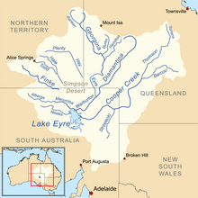
The Lake Eyre basin is a drainage basin that covers just under one-sixth of all Australia. It is the largest endorheic basin in Australia and amongst the largest in the world, covering about 1,200,000 square kilometres (463,323 sq mi), including much of inland Queensland, large portions of South Australia and the Northern Territory, and a part of western New South Wales. The basin is also one of the largest, least-developed arid zone basins with a high degree of variability anywhere. It supports only about 60,000 people and has no major irrigation, diversions or flood-plain developments. Low density grazing that sustains a large amount of wildlife is the major land use, occupying 82% of the total land within the basin. The Lake Eyre basin of precipitation to a great extent geographically overlaps the Great Artesian Basin underneath.

The Cooper Creek is one of the most famous rivers in Australia because it was the site of the death of the explorers Burke and Wills in 1861. It is sometimes known as the Barcoo River from one of its tributaries and is one of three major Queensland river systems that flow into the Lake Eyre basin. The flow of the creek depends on monsoonal rains falling months earlier and many hundreds of kilometres away in eastern Queensland. It is 1,300 kilometres (810 mi) in length.
The Finke River, or Larapinta (Arrernte), is a river in central Australia, one of four main rivers of the Lake Eyre Basin and thought to be the oldest riverbed in the world. It flows for only a few days a year and when this happens, its water usually disappears into the sands of the Simpson Desert, rarely if ever reaching Lake Eyre.

The Paroo River, a series of waterholes, connected in wet weather as a running stream of the Darling catchment within the Murray–Darling basin, is located in the South West region of Queensland and Far West region of New South Wales, Australia. It is the home of the Paarkantji people.

The Warrego River is an intermittent river that is part of the Darling catchment within the Murray–Darling basin, which is located in South West Queensland and in the Orana region of New South Wales, Australia. The Warrego River is the northernmost tributary of the Darling River.

Innamincka, formerly Hopetoun, is a township and locality in north-east South Australia with a population of 44 people as of the 2016 census. By air it is 820 kilometres north-east of the state capital, Adelaide, and 365 kilometres north-east of the closest town, Lyndhurst. It is 66 kilometres north-east of the Moomba Gas Refinery. The town lies within the Innamincka Regional Reserve and is surrounded by the Strzelecki Desert to the south and the Sturt Stony Desert to the north. It is linked by road to Lyndhurst via the Strzelecki Track, to the Birdsville Developmental Road via Cordillo Downs Road and Arrabury Road, and the Walkers Crossing Track to the Birdsville Track. The Walkers Crossing Track is closed in summer and only traversable in dry weather. The township is situated along the Cooper Creek, a part of the Lake Eyre basin.

The Shire of Diamantina is a local government area in Central West Queensland, bordering South Australia and the Northern Territory. Its administrative centre is in the town of Bedourie.

The Outback Communities Authority (OCA) is a statutory authority in South Australia (SA) created under the Outback Communities Act 2009. It has been established to "manage the provision of public services and facilities to outback communities" which are widely dispersed across the Pastoral Unincorporated Area which covers almost 60% of South Australia's land area. The authority has its seat at both Port Augusta which is located outside the unincorporated area and at Andamooka. The authority serves an area of 624,339 square kilometres, slightly smaller than France. The area has a population of 3,750, of whom 639 are Indigenous Australians, and includes several large pastoral leases and mining operations.
The Warburton River is a freshwater stream in the far north of South Australia that flows in a south westerly direction and discharges into the eastern side of Lake Eyre. It is one of the state's largest rivers, and is part of the Lake Eyre Basin. It runs along the eastern side of the Simpson Desert, and drains water from Eyre Creek, the Diamantina and Georgina rivers from Goyder Lagoon, carrying it into Lake Eyre during its infrequent floods.

The Bulloo RiverBUUL-oo is an isolated drainage system in western Queensland, central Australia. Its floodplain, which extends into northern New South Wales, is an important area for waterbirds when inundated. It comprises most of the Bulloo-Bancannia drainage basin.

The Tirari Desert is a 15,250 square kilometres (5,888 sq mi) desert in the eastern part of the Far North region of South Australia. It stretches 212 km from north to south and 153 km from east to west.

Arabana or Arabuna is an Australian Aboriginal language of the Pama–Nyungan family, spoken by the Wongkanguru and Arabana people.

The Burke River is an ephemeral river in Central West Queensland, Australia. The river was named in memory of Robert O'Hara Burke of the Burke and Wills expedition.
Yapunyah Waterhole lies in the Mulga Lands bioregion of western Queensland. The waterhole is about two kilometres long and covers approximately 22 hectares when full. It is defined as a permanent waterhole in a region where permanent waterholes are extremely rare and therefore provide important refuges for aquatic plants and animals. These rare waterholes were also vital for Aboriginal people and provided both spiritual and physical nourishment.
The Settlement Creek is a creek located in the Northern Territory and the state of Queensland, Australia.
The Alberga River, also known as the Alberga Creek, is an ephemeral river that is part of the Lake Eyre basin located in the Far North region of the Australian state of South Australia.
The Arabana, also known as the Ngarabana, are an Aboriginal Australian people of South Australia.
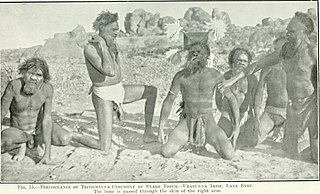
The Wangkangurru, also written Wongkanguru and Wangkanguru, are an Aboriginal Australian people of the Simpson Desert area in the state of South Australia. They also refer to themselves as Nharla.