
The Shire of Burdekin is a local government area located in North Queensland, Australia in the Dry Tropics region. The district is located between Townsville and Bowen in the delta of the Burdekin River. The shire covers an area of 5,044 square kilometres (1,947 sq mi). It has existed as a local government entity since 1888. In the 2021 census, the Shire of Burdekin had a population of 16,692 people.

Bedourie is a town and a locality in the Shire of Diamantina, Queensland, Australia. It is on the border with the Northern Territory. In the 2021 census, the locality of Bedourie had a population of 150 people.
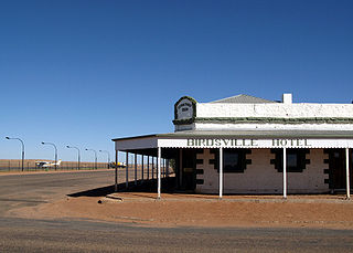
Birdsville is a rural town and locality in the Shire of Diamantina, Queensland, Australia. The locality is on the Queensland border with both the Northern Territory and South Australia. The town is situated 10 kilometres (6 mi) north of the South Australian border. In the 2021 census, the locality of Birdsville had a population of 110 people.

The Shire of Balonne is a local government area in South West Queensland, Australia, over 500 kilometres (310 mi) from the state capital, Brisbane. It covers an area of 31,104 square kilometres (12,009.3 sq mi), and has existed as a local government entity since 1879. It is headquartered in its main town, St George.

Betoota is a ghost town within the locality of Birdsville, in the Shire of Diamantina, in the Channel Country of Central West Queensland, Australia. Betoota is situated on a gibber plain 170 kilometres (110 mi) east of Birdsville and 227 kilometres (141 mi) west of Windorah.

Innamincka, formerly Hopetoun, is a township and locality in north-east South Australia. By air it is 820 kilometres north-east of the state capital, Adelaide, and 365 kilometres north-east of the closest town, Lyndhurst. It is 66 kilometres north-east of the Moomba Gas Refinery. The town lies within the Innamincka Regional Reserve and is surrounded by the Strzelecki Desert to the south and the Sturt Stony Desert to the north. It is linked by road to Lyndhurst via the Strzelecki Track, to the Birdsville Developmental Road via Cordillo Downs Road and Arrabury Road, and the Walkers Crossing Track to the Birdsville Track. The Walkers Crossing Track is closed in summer and only traversable in dry weather. The township is situated along the Cooper Creek, a part of the Lake Eyre basin.
The Shire of Quilpie is a local government area in South West Queensland, Australia. It covers an area of 67,415 square kilometres (26,029 sq mi), and its administrative centre is the town of Quilpie.

The Shire of Bulloo is a local government area in South West Queensland, Australia.
The Shire of Barcoo is a local government area in Central West Queensland, Australia.

The Shire of Boulia is a local government area in Central West Queensland, bordering the Northern Territory. Its administrative centre is in the town of Boulia.

The Shire of McKinlay is a local government area in outback north-western Queensland, Australia.

The Shire of Richmond is a local government area in north western Queensland, Australia.

The Shire of Flinders is a local government area in north-western Queensland, Australia.

The Shire of Douglas is a local government area in Far North Queensland. It is located on the coast north of the city of Cairns. The shire, administered from the town of Mossman, covers an area of 2,428 square kilometres (937.5 sq mi), and existed as a local government entity from 1880 until 2008, when it was amalgamated with the City of Cairns to become the Cairns Region. Following a poll in 2013, the Shire of Douglas was re-established on 1 January 2014.
The Shire of Carpentaria is a local government area in Far North Queensland, Australia on the Gulf of Carpentaria, for which it is named.

The Shire of Burke is a local government area in North West Queensland, Australia. The shire lies on the south coast of the Gulf of Carpentaria and abuts the border with the Northern Territory. It covers an area of 39,864 square kilometres (15,391.6 sq mi), and has existed as a local government entity since 1885. The major town and administrative centre of the shire is Burketown.

The Outback Communities Authority (OCA) is a statutory authority in South Australia (SA) created under the Outback Communities Act 2009. It has been established to "manage the provision of public services and facilities to outback communities" which are widely dispersed across the Pastoral Unincorporated Area which covers almost 60% of South Australia's land area. The authority has its seat at both Port Augusta which is located outside the unincorporated area and at Andamooka. The authority serves an area of 624,339 square kilometres, slightly smaller than France. The area has a population of 3,750, of whom 639 are Indigenous Australians, and includes several large pastoral leases and mining operations.

The Wujal Wujal Aboriginal Shire is a local government area in Far North Queensland, Australia. It is managed as a Deed of Grant in Trust under the Local Government Act 2004.

Macumba River, once known as Treuer River, is an ephemeral freshwater stream in the far north of South Australia, that is part of the Lake Eyre Basin.

Farrars Creek is an rural locality in the Shire of Barcoo, Queensland, Australia. In the 2021 census, Farrars Creek had a population of 16 people.

