Shire of Richmond

Last updated

Shire of Richmond
Queensland
Richmond LGA Qld.png
Location within Queensland
Population806 (2018) [1]
 • Density0.030322/km2 (0.07853/sq mi)
Established1916
Area26,581 km2 (10,263.0 sq mi) [1]
MayorJohn Wharton
Council seat Richmond
Region North West Queensland
State electorate(s) Traeger
Federal division(s) Kennedy
Richmond Shire Council Queensland logo.jpg
Website Shire of Richmond
LGAs around Shire of Richmond:
McKinlay Croydon Etheridge
McKinlay Shire of Richmond Flinders
Winton Winton Winton

The Shire of Richmond is a local government area in north western Queensland, Australia.

Contents

It covers an area of 26,581 square kilometres (10,263.0 sq mi), and has existed as a local government entity since 1916. It is part of the Gulf Country.

History

Wanamarra (also known as Maykulan and Wunumura is an Australian Aboriginal language in North West Queensland. The language region includes areas within the Shire of McKinlay, Shire of Cloncurry and Shire of Richmond, including the Flinders River area, and the towns of Kynuna and Richmond. [2]

The Shire of Wyangarie, named for a prominent grazing homestead in the area, [3] was created on 1 January 1916 out of part of the Shire of Flinders under the Local Authorities Act 1902. [4] On 24 July 1930, it lost part of its area to Shire of McKinlay. On 31 July 1954, it was renamed Richmond.

Towns and localities

The Shire of Richmond includes the following settlements:

Amenities

The Richmond Shire Council operate several services in the town including:

Chairmen and Mayors

Population

YearPopulation
19331,776
19471,478
19541,586
19612,214
19661,828
19711,409
19761,442
19811,383
19861,198
19911,108
19961,179
20011,050
2006902
2011827
2016791

Related Research Articles

<span class="mw-page-title-main">Shire of Burdekin</span> Local government area in Queensland, Australia

The Shire of Burdekin is a local government area located in North Queensland, Australia in the Dry Tropics region. The district is located between Townsville and Bowen in the delta of the Burdekin River.

<span class="mw-page-title-main">Shire of Paroo</span> Local government area in Queensland, Australia

The Shire of Paroo is a local government area in South West Queensland, Australia. The administrative centre is the town of Cunnamulla. The Paroo Shire covers an area of 47,623 square kilometres (18,387 sq mi). In the 2021 census, the Shire had a population of 1,679.

<span class="mw-page-title-main">Flinders River</span> River in Queensland, Australia

The Flinders River is the longest river in Queensland, Australia, at approximately 1,004 kilometres (624 mi). It was named in honour of the explorer Matthew Flinders. The catchment is sparsely populated and mostly undeveloped. The Flinders rises on the western slopes of the Great Dividing Range in North West Queensland and flows generally north-west through the Gulf Country, across a large, flat clay pan, before entering the Gulf of Carpentaria.

<span class="mw-page-title-main">City of Mount Isa</span> Local government area in Queensland, Australia

The City of Mount Isa is a local government area in north west Queensland. The City covers the urban locality of Mount Isa, the administrative centre, and surrounding area, sharing a boundary with the Northern Territory to the west.

<span class="mw-page-title-main">Shire of Balonne</span> Local government area in Queensland, Australia

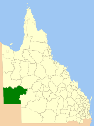
The Shire of Balonne is a local government area in South West Queensland, Australia, over 500 kilometres (310 mi) from the state capital, Brisbane. It covers an area of 31,104 square kilometres (12,009.3 sq mi), and has existed as a local government entity since 1879. It is headquartered in its main town, St George.

<span class="mw-page-title-main">Richmond, Queensland</span> Town in Queensland, Australia

Richmond is a rural town and locality in the Shire of Richmond, Queensland, Australia. In the 2016 census, the locality of Richmond had a population of 648 people.

<span class="mw-page-title-main">Shire of Murweh</span> Local government area in Queensland, Australia

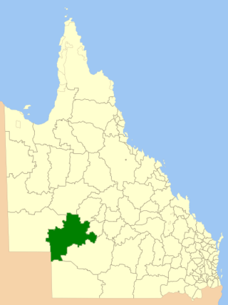
The Shire of Murweh is a local government area in the Maranoa district, which is part of South West Queensland, Australia. The administrative centre and largest town in the shire is Charleville. In June 2018, the Shire of Murweh had a population of 4,318.

<span class="mw-page-title-main">Shire of Barcoo</span> Local government area in Queensland, Australia

The Shire of Barcoo is a local government area in Central West Queensland, Australia. In June 2018, the shire had a population of 267 people.

<span class="mw-page-title-main">Shire of Winton</span> Local government area in Queensland, Australia

The Shire of Winton is a local government area in Central West Queensland, Australia. It covers an area of 53,814 square kilometres (20,777.7 sq mi), and has existed as a local government entity since 1887. Its administrative centre is located in the town of Winton. It is named after Winton, Dorset, England, the birthplace of Robert Allen, the first white settler in the Winton (Queensland) area.

<span class="mw-page-title-main">Shire of Diamantina</span> Local government area in Queensland, Australia

The Shire of Diamantina is a local government area in Central West Queensland, bordering South Australia and the Northern Territory. Its administrative centre is in the town of Bedourie.

<span class="mw-page-title-main">Shire of Boulia</span> Local government area in Queensland, Australia

The Shire of Boulia is a local government area in Central West Queensland, bordering the Northern Territory. Its administrative centre is in the town of Boulia.

<span class="mw-page-title-main">Shire of Cloncurry</span> Local government area in Queensland, Australia

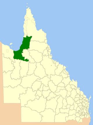
The Shire of Cloncurry is a local government area in North West Queensland, Australia. It covers an area of 47,971 square kilometres (18,521.7 sq mi), and has existed as a local government entity since 1884. The major town and administrative centre of the shire is Cloncurry.

<span class="mw-page-title-main">Shire of Mckinlay</span> Local government area in Queensland, Australia

The Shire of Mckinlay is a local government area in outback north-western Queensland, Australia.

<span class="mw-page-title-main">Shire of Flinders (Queensland)</span> Local government area in Queensland, Australia

The Shire of Flinders is a local government area in north-western Queensland, Australia.

<span class="mw-page-title-main">Shire of Etheridge</span> Local government area in Queensland, Australia

The Shire of Etheridge is a local government area in Far North Queensland, Australia in what is known as the Savannah Gulf region. Its economy is based on cattle grazing and mining.

<span class="mw-page-title-main">Shire of Croydon</span> Local government area in Queensland, Australia

The Shire of Croydon is a local government area in western Queensland, Australia. The shire, administered from the town of Croydon, covers an area of 29,498 square kilometres (11,389.2 sq mi). The council consists of a mayor plus four councillors, each of whom represents the entire Shire.

<span class="mw-page-title-main">Shire of Carpentaria</span> Local government area in Queensland, Australia

The Shire of Carpentaria is a local government area in Far North Queensland, Australia on the Gulf of Carpentaria, for which it is named.

<span class="mw-page-title-main">Shire of Burke</span> Local government area in Queensland, Australia

The Shire of Burke is a local government area in North West Queensland, Australia. The shire lies on the south coast of the Gulf of Carpentaria and abuts the border with the Northern Territory. It covers an area of 39,864 square kilometres (15,391.6 sq mi), and has existed as a local government entity since 1885. The major town and administrative centre of the shire is Burketown.

<span class="mw-page-title-main">Shire of Cook</span> Local government area in Queensland, Australia

The Shire of Cook is a local government area in Far North Queensland, Australia. The Shire covers most of the eastern and central parts of Cape York Peninsula, the most northerly section of the Australian mainland.

<span class="mw-page-title-main">Barcaldine Region</span> Local government area in Queensland, Australia

The Barcaldine Region is a local government area in Central West Queensland, Australia. Established in 2008, it was preceded by three previous local government areas which had existed for over a century.

References

  1. 1 2 "3218.0 – Regional Population Growth, Australia, 2017-18: Population Estimates by Local Government Area (ASGS 2018), 2017 to 2018". Australian Bureau of Statistics. Australian Bureau of Statistics. 27 March 2019. Retrieved 25 October 2019. Estimated resident population, 30 June 2018.
  2. CC BY icon-80x15.png This Wikipedia article incorporates CC-BY-4.0 licensed text from: "Wanamarra". Queensland Aboriginal and Torres Strait Islander languages map. State Library of Queensland . Retrieved 5 February 2020.
  3. Richmond Shire Council - Official Website. Accessed 11 December 2006.
  4. Queensland Government Gazette, Vol. 105, 23 October 1915.
  5. "Richmond Shire Council library services". Public Libraries Connect. State Library of Queensland. 20 September 2016. Archived from the original on 5 February 2018. Retrieved 6 February 2018.
  6. Pugh, Theophilus Parsons (1927). Pugh's Almanac for 1927 . Retrieved 13 June 2014.
  7. "Richmond Shire Council - Mayor John Wharton". www.richmond.qld.gov.au. Retrieved 20 January 2022.
  8. "2008 Richmond Shire Council - Mayoral Election - Election Summary" . Retrieved 4 December 2017.
  9. "2012 Richmond Shire Council - Mayoral Election - Election Summary" . Retrieved 4 December 2017.
  10. "2016 Richmond Shire Council - Mayoral Election - Election Summary" . Retrieved 4 December 2017.
  11. "2020 Local Government Elections: Saturday, 28 March 2020". Electoral Commission of Queensland. 2020. Retrieved 16 June 2020.[ dead link ]

Coordinates: 20°43′S143°08′E / 20.717°S 143.133°E / -20.717; 143.133