Aboriginal Shire of Kowanyama

Last updated

Aboriginal Shire of Kowanyama
Queensland
Kowanyama LGA Qld.png
Location within Queensland
Population977 (2018) [1]
 • Density0.38239/km2 (0.9904/sq mi)
Established1987
Area2,555 km2 (986.5 sq mi) [1]
MayorRobert Michael Sands
Council seat Kowanyama
Region Cape York
State electorate(s) Cook
Federal division(s) Leichhardt
Kowanyama Aboriginal Shire Logo.png
Website Aboriginal Shire of Kowanyama
LGAs around Aboriginal Shire of Kowanyama:
Gulf of Carpentaria Pormpuraaw Cook
Gulf of Carpentaria Aboriginal Shire of Kowanyama Carpentaria
Carpentaria Carpentaria Carpentaria

The Aboriginal Shire of Kowanyama is a special local government area which is located on western Cape York Peninsula in Queensland, Australia. It is managed under a Deed of Grant in Trust under the Local Government (Community Government Areas) Act 2004.

Contents

History

The area originally was set up as the Mitchell River Mission in 1916. Aboriginal people from the region were gradually drawn from their traditional lands into the mission settlement. Language groups associated with countries in the Kowanyama region are Yir-Yoront, Yirrk Thangalkl, Koko Bera and Kunjen (Uw Oykangand and Olkola dialects).

Kunjen (also known as Koko Wanggara, Ngundjan and Olkola) is a language of Western Cape York. The Kunjen language region includes the landscape within the local government boundaries of Kowanyama Community Council and Cook Shire Council. [2]

Yir Yiront (also known as Yiront, Jirjoront, Yir-yiront, and Kokomindjan) is an Australian Aboriginal language. Its traditional language region is in Western Cape York within the local government areas of Aboriginal Shire of Kowanyama and Shire of Cook, in the catchments of the Coleman River and Mitchell River. Following the removal of Aboriginal people from their traditional lands, it is also spoken in Pormpuraaw and Kowanyama. [3]

In 1967 the Anglican church were no longer able to sustain their activities in the area as a Church Mission. The Department of Aboriginal and Islander Affairs, a government department, under the Act continued running the affairs of the community.

On 23 July 1987, under the Community Services (Aborigines) Act 1984, a Deed of Grant in Trust was given to the Kowanyama community over the lands in the Mitchell River delta. Like other DOGIT communities of the time, Kowanyama had a town Council elected by Aboriginal people living in the community. The newly formed Kowanyama Council assumed responsibility for implementing certain conditions of the DOGIT. Seven elected Aboriginal residents hold three year terms in office.

Responsibilities

As the Shire operates under the Local Government Act 2009, the Shire Council's responsibilities are the generally the same as other local government in remote Queensland including for fisheries, the alcohol management and even operation of some commercial enterprises.

Community Justice Group

Front view of Kowanyama Community Justice Group's 'Courthouse' KCJG Nov08.jpg
Front view of Kowanyama Community Justice Group's 'Courthouse'

A Community Justice Group operates within Kowanyama. This group is made up of respected members in the community. They meet to discuss issues within the town and make recommendations to Council.[ citation needed ]

The community also has a Council of Elders, who are consulted by the Kowanyama Council when making community decisions. The elders operate in conjunction with the Lands Office.[ citation needed ]

The Lands Office

Front view of Kowanyama Land and Natural Resource Management office, Gilbert St. KLNRM Nov08.jpg
Front view of Kowanyama Land and Natural Resource Management office, Gilbert St.

The Kowanyama Aboriginal Land and Natural Resources Management Office (KALNRMO) works to promote and facilitate aboriginal management of the natural and cultural resources of Kowanyama country by the people of Kowanyama. Through community consultation and direction, KALNRMO has developed a community development agenda for the Kowanyama region, including:[ citation needed ]

Through the initiatives of KALNRMO, the Kowanyama community is widely regarded as a leader in indigenous land management issues. Since 1987, Kowanyama has effected substantial local control over fishing in the Mitchell River Delta, including the closure of some waters to non-Aboriginal fishing under state fisheries legislation. This action, funded through the enterprise income of the Kowanyama Aboriginal Council, has provided Aboriginal people access to the River's fish stocks for their cultural and economic needs. In this way, Aboriginal people can fish and hunt as they have done for many thousands of years.[ citation needed ]

KALNRMO employs Indigenous rangers as part of a cultural and economic development programme. The Kowanyama Rangers implement land management strategies in many areas of the DOGIT, and, in addition to tourism and visitor management, patrol closed and open waters. The Rangers also observe fisheries regulations, especially for illegal commercial or recreational fishing in closed waters. Beginning in 2007, the Rangers monitor threatened turtle populations and participate in the Carpentaria Ghost Nets Programme to remove debris (primarily fishing nets) discarded into the Gulf of Carpentaria by commercial fishermen from Australia and Indonesia.[ citation needed ]

Mayors

See also

Related Research Articles

<span class="mw-page-title-main">Cape York Peninsula</span> Peninsula in Far North Queensland, Australia

Cape York Peninsula is a peninsula located in Far North Queensland, Australia. It is the largest wilderness in northern Australia. The land is mostly flat and about half of the area is used for grazing cattle. The relatively undisturbed eucalyptus-wooded savannahs, tropical rainforests and other types of habitat are now recognised and preserved for their global environmental significance. Although much of the peninsula remains pristine, with a diverse repertoire of endemic flora and fauna, some of its wildlife may be threatened by industry and overgrazing as well as introduced species and weeds.

<span class="mw-page-title-main">Mitchell River (Queensland)</span> River in Queensland, Australia

The Mitchell River is a river in Far North Queensland, Australia. The river rises on the Atherton Tableland about 50 kilometres (31 mi) northwest of Cairns and flows about 750 kilometres (470 mi) northwest across Cape York Peninsula from Mareeba to the Gulf of Carpentaria.

<span class="mw-page-title-main">Far North Queensland</span> Region in Queensland, Australia

Far North Queensland (FNQ) is the northernmost part of the Australian state of Queensland. Its largest city is Cairns and it is dominated geographically by Cape York Peninsula, which stretches north to the Torres Strait, and west to the Gulf Country. The waters of Torres Strait include the only international border in the area contiguous with the Australian mainland, between Australia and Papua New Guinea.

<span class="mw-page-title-main">Kowanyama, Queensland</span> Town in Queensland, Australia

Kowanyama is a town and coastal locality in the Aboriginal Shire of Kowanyama, Queensland, Australia.

<span class="mw-page-title-main">Pormpuraaw, Queensland</span> Town in Queensland, Australia

Pormpuraaw is a coastal town and a locality in the Aboriginal Shire of Pormpuraaw, Queensland, Australia. Pormpuraaw is an Aboriginal community situated on the west coast of Cape York Peninsula approximately halfway between Karumba and Weipa on the Edward River. It is 650 kilometres (400 mi) by road from Cairns. Pormpuraaw currently has a 4-man police station.

<span class="mw-page-title-main">Shire of Mckinlay</span> Local government area in Queensland, Australia

The Shire of Mckinlay is a local government area in outback north-western Queensland, Australia.

<span class="mw-page-title-main">Shire of Carpentaria</span> Local government area in Queensland, Australia

The Shire of Carpentaria is a local government area in Far North Queensland, Australia on the Gulf of Carpentaria, for which it is named.

<span class="mw-page-title-main">Shire of Cook</span> Local government area in Queensland, Australia

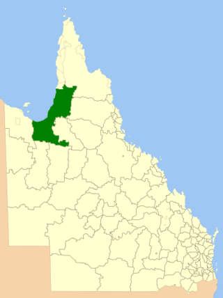
The Shire of Cook is a local government area in Far North Queensland, Australia. The Shire covers most of the eastern and central parts of Cape York Peninsula, the most northerly section of the Australian mainland.

<span class="mw-page-title-main">Shire of Torres</span> Local government area in Queensland, Australia

The Shire of Torres is a local government area located in Far North Queensland, Australia, covering large sections of the Torres Strait Islands and the northern tip of Cape York Peninsula north of 11°S latitude. It holds two distinctions—it is the northernmost Local Government Area in Australia, and is the only one to abut an international border – it is at one point just 73 kilometres (45 mi) from Papua New Guinea. It is administered from Thursday Island.

<span class="mw-page-title-main">Shire of Mornington (Queensland)</span> Local government area in Queensland, Australia

The Shire of Mornington is a local government area in northwestern Queensland, Australia. The shire covers the Wellesley Islands, which includes Mornington Island; the South Wellesley Islands; Bountiful Islands; and West Wellesley / Forsyth Islands groups in the Gulf of Carpentaria.

<span class="mw-page-title-main">Aboriginal Shire of Palm Island</span> Local government area in Queensland, Australia

The Aboriginal Shire of Palm Island is a special local government area of Queensland, Australia, managed by the Palm Island Aboriginal Shire Council under a Deed of Grant in Trust granted to the community on 27 October 1986. The local council was previously the Palm Island Community Council, which had far fewer powers. The shire is located on the Palm Island group, off the north Queensland coast near the city of Townsville.

<span class="mw-page-title-main">Aboriginal Shire of Doomadgee</span> Local government area in Queensland, Australia

The Aboriginal Shire of Doomadgee is a special local government area in North West Queensland, Queensland, Australia. It is managed under a Deed of Grant in Trust under the Local Government Act 2004.

<span class="mw-page-title-main">Northern Peninsula Area Region</span> Local government area in Queensland, Australia

The Northern Peninsula Area Region is a local government area in Far North Queensland, Australia, covering areas on the northwestern coast of Cape York Peninsula. It was created in March 2008 out of three Aboriginal Shires and two autonomous Island Councils during a period of statewide local government reform. In June 2018, the area had a population of 3,069.

<span class="mw-page-title-main">Aboriginal Shire of Pormpuraaw</span> Local government area in Queensland, Australia

The Aboriginal Shire of Pormpuraaw is a special local government area which is located on western Cape York Peninsula in Queensland, Australia. It is managed under a Deed of Grant in Trust under the Local Government Act 2004.

<span class="mw-page-title-main">Aboriginal Shire of Yarrabah</span> Local government area in Queensland, Australia

The Aboriginal Shire of Yarrabah is a special local government area in Far North Queensland, Queensland, Australia, east and southeast of Cairns on Cape Grafton. It is managed under a Deed of Grant in Trust under the Local Government Act 2004.

The Thaayorre, or Kuuk Thaayore, are an Australian people living on the southwestern part of the Cape York Peninsula, Queensland in Australia, primarily in the settlement Pormpuraaw, having its foundation in the Edward River Mission.

The Uw Oykangand, otherwise known as the Kwantari, are an Aboriginal Australian people living on the southwestern part of the Cape York Peninsula, in the state of Queensland in Australia. Their neighbours to the northwest are the Yir-Yoront people. Their traditional lands are around the Alice River and the Crosbie River, and further west around the Mitchell River and into Gulf Country.

<span class="mw-page-title-main">Aboriginal Shire of Hope Vale</span> Local government area in Queensland, Australia

The Aboriginal Shire of Hope Vale is a local government area in Far North Queensland, Queensland, Australia, north of the town of Cooktown. The majority of the Shire consists of Deed of Grant land that is held for the benefit of Aboriginal people particularly concerned with the land and their ancestors and descendants.

The Coleman River is a river on the Cape York Peninsula in Far North Queensland, Australia.

The Ajabakan were an indigenous Australian people of the Cape York Peninsula of Queensland.

References

  1. 1 2 "3218.0 – Regional Population Growth, Australia, 2017–18: Population Estimates by Local Government Area (ASGS 2018), 2017 to 2018". Australian Bureau of Statistics. Australian Bureau of Statistics. 27 March 2019. Archived from the original on 27 March 2019. Retrieved 25 October 2019. Estimated resident population, 30 June 2018.
  2. CC BY icon-80x15.png This Wikipedia article incorporates CC-BY-4.0 licensed text from: "Queensland Aboriginal and Torres Strait Islander languages map". State Library of Queensland. State Library of Queensland . Retrieved 30 January 2020.
  3. CC BY icon-80x15.png This Wikipedia article incorporates CC-BY-4.0 licensed text from: "Yir Yiront". Queensland Aboriginal and Torres Strait Islander languages map. State Library of Queensland . Retrieved 30 January 2020.
  4. "2008 Kowanyama Aboriginal Shire Council – Mayoral Election – Election Summary". results.ecq.qld.gov.au. Archived from the original on 5 April 2019. Retrieved 4 December 2017.
  5. "2012 Kowanyama Aboriginal Shire Council – Mayoral Election – Election Summary". results.ecq.qld.gov.au. Archived from the original on 1 April 2018. Retrieved 4 December 2017.
  6. "2016 Kowanyama Aboriginal Shire Council – Mayoral Election – Election Summary". results.ecq.qld.gov.au. Archived from the original on 27 March 2018. Retrieved 4 December 2017.
  7. "2020 Local Government Elections: Saturday, 28 March 2020". Electoral Commission of Queensland. 2020. Retrieved 16 June 2020.[ dead link ]

15°28′47″S141°44′31″E / 15.4796°S 141.7420°E / -15.4796; 141.7420