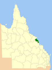
The Shire of Sarina was a local government area located in the Central Queensland region of Queensland, Australia. The shire, administered from the town of Sarina, covered an area of 1,444.3 square kilometres (557.6 sq mi), and existed as a local government entity from 1912 until 2008, when it amalgamated with the City of Mackay and the Shire of Mirani to form the Mackay Region.

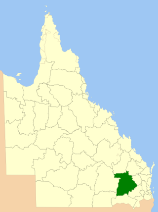
The Shire of Mirani was a local government area located in the North Queensland region of Queensland, Australia. The shire, administered from the town of Mirani, covered an area of 3,280.2 square kilometres (1,266.5 sq mi), and existed as a local government entity from 1916 until 2008, when it amalgamated with the City of Mackay and the Shire of Sarina to form the Mackay Region.

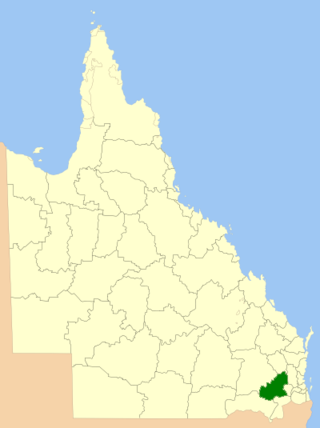
The City of Mackay was a local government area located in the Central Queensland region of Queensland, Australia, encompassing the regional city of Mackay and the surrounding region. The City was created as a municipal borough in 1869, and prior to amalgamation with the Shire of Pioneer in 1994, the City was limited to the central suburbs on the south shore of the Pioneer River. From 1994 until 2008, the City covered an area of 2,897.5 square kilometres (1,118.7 sq mi). In 2008, it amalgamated with the Shires of Mirani and Sarina to become the Mackay Regional Council.

The North Burnett Region is a local government area in Queensland, Australia in the northern catchment of the Burnett River. Established in 2008, it was preceded by several previous local government areas with histories extending back to the early 1900s.

The Barcaldine Region is a local government area in Central West Queensland, Australia. Established in 2008, it was preceded by three previous local government areas which had existed for over a century.

The Cassowary Coast Region is a local government area in the Far North Queensland region of Queensland, Australia, south of Cairns and centred on the towns of Innisfail, Cardwell and Tully. It was created in 2008 from a merger of the Shire of Cardwell and the Shire of Johnstone.

The Tablelands Region is a local government area in Far North Queensland, Australia inland from the city of Cairns. Established in 2008, it was preceded by four previous local government areas which dated back more than a century. On 1 January 2014, one of those local government areas, the Shire of Mareeba, was re-established independent of the Tablelands Region.

The Blackall-Tambo Region is a local government area in Central West Queensland, Australia. Established in 2008, it was preceded by two previous local government areas dating from the 1870s.

The Bundaberg Region is a local government area in the Wide Bay–Burnett region of Queensland, Australia, about 360 kilometres (220 mi) north of Brisbane, the state capital. It is centred on the city of Bundaberg, and also contains a significant rural area surrounding the city. It was created in 2008 from a merger of the City of Bundaberg with the Shires of Burnett, Isis and Kolan.

The Rockhampton Region is a local government area (LGA) in Central Queensland, Australia, located on the Tropic of Capricorn about 600 kilometres (370 mi) north of Brisbane. Rockhampton is the region's major city; the region also includes the Fitzroy River, Mount Archer National Park and Berserker Range.
The Toowoomba Region is a local government area (LGA) located within the larger Darling Downs region of Queensland, Australia. Established in 2008, the LGA was preceded by several other local government authorities with histories extending back to the early 1900s and beyond.
The Southern Downs Region is a local government area (LGA) in the Darling Downs region of Queensland, Australia. The region runs along the state's southern boundary with New South Wales and was created in 2008 from a merger of the Shire of Warwick and the Shire of Stanthorpe. As at 2024, it has an area of 7,088 square kilometres (2,737 sq mi).
Western Downs Region is a local government area in Queensland, Australia. The Western Downs Regional Council manages an area of 37,937 square kilometres (14,648 sq mi), which is slightly smaller than Switzerland, although with a population of 34,467 in June 2018, it is over 228 times less densely populated.

The Goondiwindi Region is a local government area located in the Darling Downs region of Queensland, Australia along the state's border with New South Wales. Established in 2008, it was preceded by three previous local government areas which dated back to the 19th century.

The Whitsunday Region is a local government area located in North Queensland, Australia. Established in 2008, it was preceded by two previous local government areas with a history extending back to the establishment of regional local government in Queensland in 1879.

The Gympie Region is a local government area in the Wide Bay–Burnett region of Queensland, Australia, about 170 kilometres (110 mi) north of Brisbane, the state capital. It is between the Sunshine Coast and Hervey Bay and centred on the town of Gympie. It was created in 2008 from a merger of the Shires of Cooloola and Kilkivan and part of the Shire of Tiaro.

The Cairns Region is a local government area in Far North Queensland, Queensland, Australia, centred on the regional city of Cairns. It was established in 2008 by the amalgamation of the City of Cairns and the Shires of Douglas and Mulgrave. However, following public protest and a referendum in 2013, on 1 January 2014, the Shire of Douglas was de-amalgamated from the Cairns Region and re-established as a separate local government authority.

Local government in Queensland, Australia, includes the institutions and processes by which towns and districts can manage their own affairs to the extent permitted by the Local Government Act 1993–2007. Queensland is divided into 78 local government areas, which may be called Cities, Towns, Shires, or Regions. Each area has a council that is responsible for providing a range of public services and utilities and derives its income from both rates and charges on resident ratepayers and grants and subsidies from the state and Commonwealth governments.
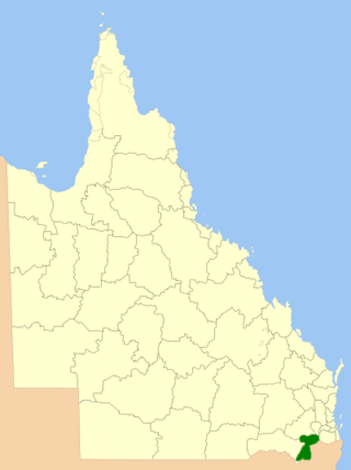
The Shire of Pioneer was a local government area surrounding the city of Mackay and including all but its innermost suburbs. The shire, administered from Mackay itself, covered an area of 2,820.1 square kilometres (1,088.8 sq mi), and existed as a local government entity from 1879 until 1994, when it was dissolved and amalgamated with City of Mackay.
Gregory Roy Williamson is the mayor of North Queensland's Mackay Regional Council, a position he has held since 2016.