Calen, Queensland

Last updated

Calen
Queensland
Calen general store, 2009.jpg
Calen general store, 2009
Australia Queensland location map.svg
Red pog.svg
Calen
Coordinates 20°53′51″S148°46′21″E / 20.8975°S 148.7725°E / -20.8975; 148.7725 (Calen (town centre))
Population427 (2021 census) [1]
 • Density5.939/km2 (15.381/sq mi)
Postcode(s) 4798
Area71.9 km2 (27.8 sq mi)
Time zone AEST (UTC+10:00)
Location
LGA(s) Mackay Region
State electorate(s) Whitsunday
Federal division(s) Dawson
Localities around Calen:
Yalboroo Pindi Pindi St Helens Beach
Eungella Hinterland Calen Coral Sea
Mount Charlton Mount Pelion Mount Ossa

Calen is a rural town and coastal locality in the Mackay Region, Queensland, Australia. [2] [3] In the 2021 census, the locality of Calen had a population of 427 people. [1]

Contents

Geography

Rotating cloud, Calen Rotating cloud at Calen near Mackay, Australia - panoramio (1).jpg
Rotating cloud, Calen

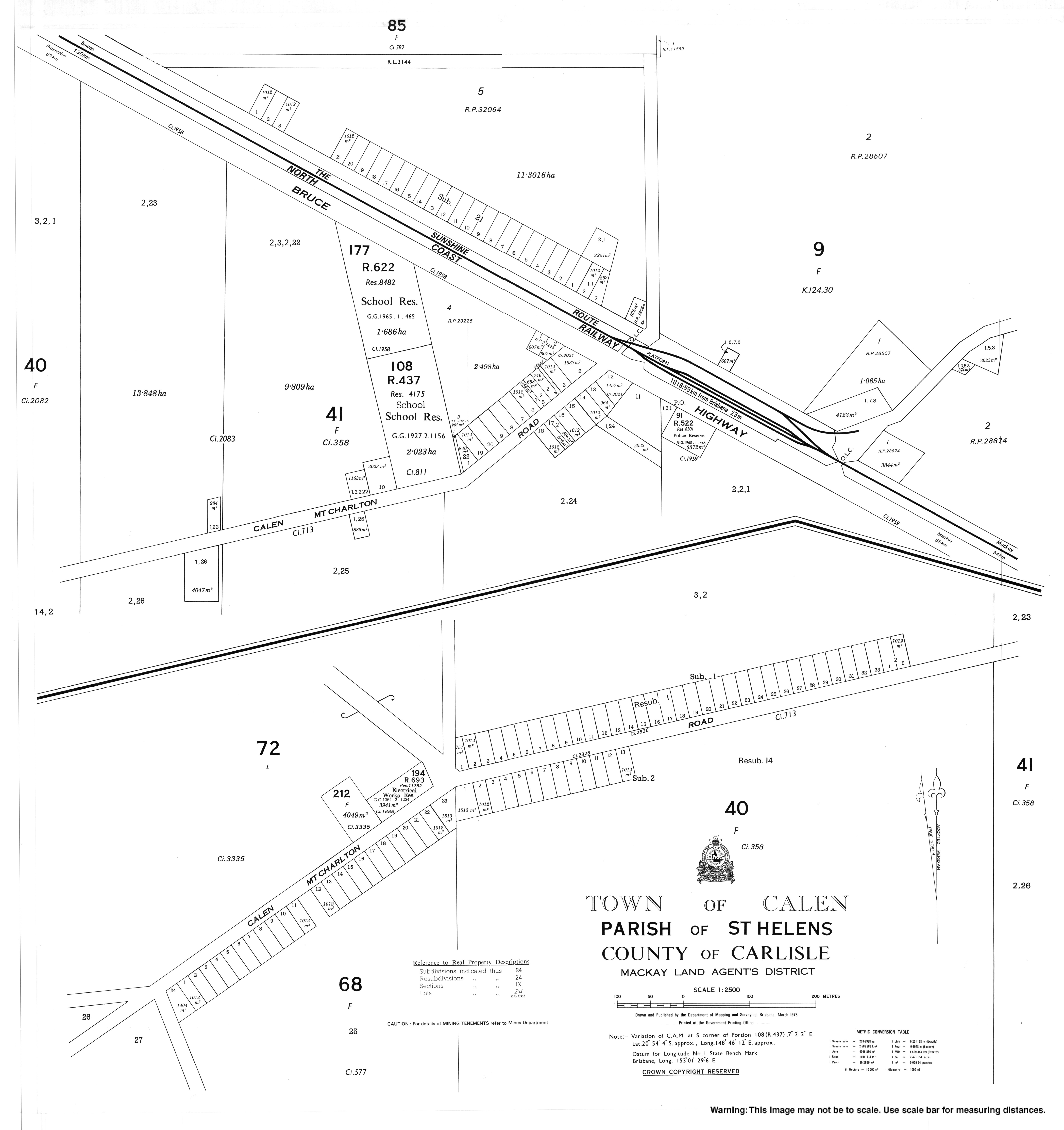
The locality of Calen is loosely bounded by One Mile Creek to the south and Blackrock Creek to the north. The land is mostly flat and used for sugar cane farming, apart from some undeveloped mountains across the western boundary of the locality and some small undeveloped hill land in the east which is on the Queensland coast. [4]

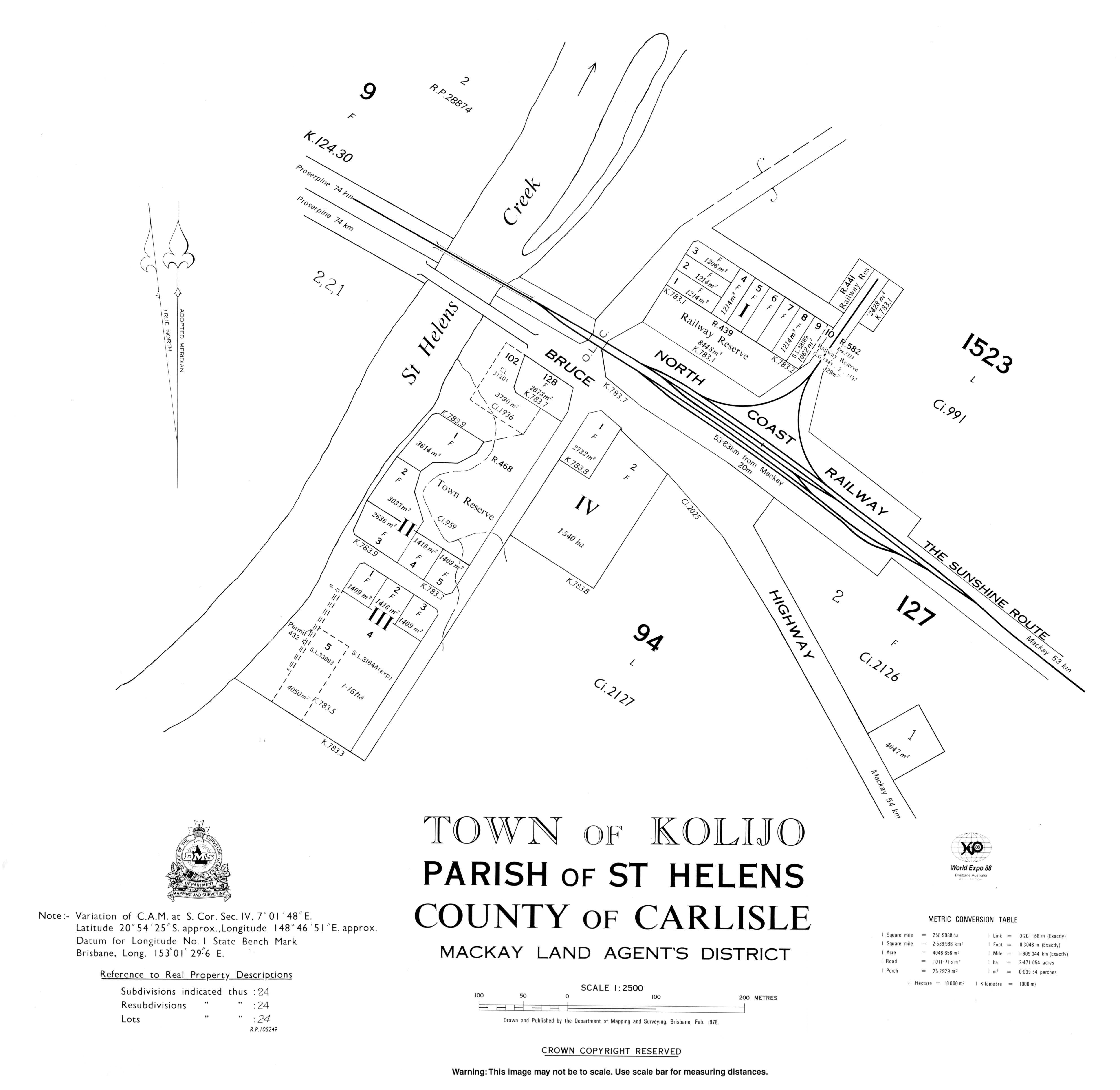
The Bruce Highway passes from the south-east to the north-west of the locality. The North Coast railway line runs immediately north and parallel to the highway. [4]

The town of Calen is located in the south-eastern part of the locality with the highway and railway passing through it. The Calen railway station ( 20°53′54″S148°46′26″E / 20.8984°S 148.7738°E / -20.8984; 148.7738 (Calen railway station) ) is located in the town. [4] [5] [6]

A second town of Kolijo is located on the south-eastern edge of the locality, again with the highway and railway passing through it. The former Kolijo railway station is located in the town ( 20°54′16″S148°46′57″E / 20.9044°S 148.7825°E / -20.9044; 148.7825 (Kolijo railway station) ). [6] Calen and Kolijo are separated by St Helens Creek, which might explain the development of two towns less than 1.5 kilometres (0.93 mi) apart. [4] [7]

A neighbourhood called Moondaba exists at the north-western edge of the locality along the highway and railway line ( 20°52′23″S148°44′18″E / 20.8731°S 148.7384°E / -20.8731; 148.7384 (Moondaba railway station) ). [6] It takes its name from the former Moondaba railway station and is reportedly an Aboriginal word meaning place of snakes. [8] Moondaba is very close to the town of Pindi Pindi to the north, but they are separated by the Blackrock Creek. [4]

The locality of Calen has a network of privately operated tramway lines for transporting sugar cane to the sugar mill. [4]

History

The town of Kolijo takes its name from the former Kolijo railway station which was named on 9 March 1923 by the Queensland Railways Department, reportedly an Aboriginal word meaning possum.

The town of Calen takes its name from the Calen railway station which was named on 8 February 1924 by the Queensland Railway Department, reportedly being an Aboriginal name meaning cloud. [9]

Calen State School opened on 24 February 1925 under head teacher Honoria Mary Doherty. In 1963, it expanded to offering secondary schooling (8-10). In 1991, it further expanded to offer secondary years 11 and 12. On 13 December 2003, it was renamed Calen District State College. [10] [11] [12]

Cameron's Pocket State School opened on 4 February 1930 and closed in 1958. [13] It was at 375 Calen Mount Charlton Road ( 20°55′13″S148°43′40″E / 20.9202°S 148.7278°E / -20.9202; 148.7278 (Cameron's Pocket State School (former)) ). [14] [15] [4]

William Pratt Memorial Church was officially opened on Saturday 23 August 1930; it was a combined Presbyterian and Methodist Church. [16] It is now Calen Uniting Church. [17] William Pratt was a pioneer sugarcane grower in the Calen area. He served on the Pioneer Shire Council and was a director of the Farleigh sugar mill. [18] [19]

Calen Post Office opened by 1933. [20]

Demographics

In the 2006 census, the town of Calen had a population of 289 people. [21]

In the 2011 census, the locality of Calen had a population of 451 people. [22]

In the 2016 census, the locality of Calen had a population of 390 people. [23]

In the 2021 census, the locality of Calen had a population of 427 people. [1]

Education

Library, Calen District State College, 2024 Library, Calen District State College, 2024.jpg
Library, Calen District State College, 2024

Calen District State College is a government primary and secondary (Prep-12) school for boys and girls at 38 McIntyre Street ( 20°53′57″S148°46′13″E / 20.8993°S 148.7704°E / -20.8993; 148.7704 (Calen District State College) ). [24] [25] In 2018, the school had an enrolment of 195 students with 22 teachers (18 full-time equivalent) and 20 non-teaching staff (12 full-time equivalent). [26] It includes a special education program. [24]

Amenities

The Mackay Regional Council operates a mobile library service on a fortnightly schedule at McIntyre Street near the school. [27] [28]

St Helen's Catholic Church is at 71 McIntyre Street ( 20°54′01″S148°45′59″E / 20.9002°S 148.7665°E / -20.9002; 148.7665 (St Helen's Catholic Church) ). It is part of the Farleigh parish. [29]

Calen Uniting Church is at 42 Mcintyre Street ( 20°53′57″S148°46′10″E / 20.8993°S 148.7694°E / -20.8993; 148.7694 (Calen Uniting/Community Church) ). [30] It is also known as the William Pratt Memorial Calen Community Church. [31] [32] As at 2020, the church was closed. [33]

The Calen branch of the Queensland Country Women's Association meets at the QCWA Hall at 120 McIntyre Street ( 20°54′00″S148°45′43″E / 20.9000°S 148.7619°E / -20.9000; 148.7619 (QCWA Hall) ). [34]

Facilities

Calen Police Station is at 5379 Bruce Highway ( 20°53′56″S148°46′25″E / 20.8989°S 148.7737°E / -20.8989; 148.7737 (Calen Police Station) ). [35] [36] [37]

Calen Ambulance Station is at 145 McIntyre Street ( 20°54′03″S148°45′34″E / 20.9008°S 148.7595°E / -20.9008; 148.7595 (Calen Ambulance Station) ). [35]

Calen SES Facility is at 17 Pratts Road ( 20°53′56″S148°46′33″E / 20.8989°S 148.7758°E / -20.8989; 148.7758 (Calen SES Facility) ). [35]

Related Research Articles

<span class="mw-page-title-main">Bowen, Queensland</span> Town in Queensland, Australia

Bowen is a coastal town and locality in the Whitsunday Region, Queensland, Australia. In the 2021 census, the locality of Bowen had a population of 11,205 people.

<span class="mw-page-title-main">Sarina, Queensland</span> Town in Queensland, Australia

Sarina is a rural town and coastal locality in the Mackay Region, Queensland, Australia. In the 2021 census, the locality of Sarina had a population of 5,619 people.

Gargett is a rural locality in the Mackay Region, Queensland, Australia. In the 2021 census, the locality of Gargett had a population of 191 people.

<span class="mw-page-title-main">Mirani, Queensland</span> Town in Queensland, Australia

Mirani is a rural town and locality in the Mackay Region, Queensland, Australia. In the 2021 census, the locality of Mirani had a population of 1,806 people.

<span class="mw-page-title-main">Seaforth, Queensland</span> Town in Queensland, Australia

Seaforth is a coastal town and locality in the Mackay Region, Queensland, Australia. In the 2021 census, the locality of Seaforth had a population of 800 people.

<span class="mw-page-title-main">Finch Hatton, Queensland</span> Town in Queensland, Australia

Finch Hatton is a rural town and locality in the Mackay Region, Queensland, Australia. In the 2021 census, the locality of Finch Hatton had a population of 531 people.

Koumala is a rural town and coastal locality in the Mackay Region, Queensland, Australia. In the 2021 census, the locality of Koumala had a population of 772 people.

Pindi Pindi is a rural locality in the Mackay Region, Queensland, Australia. In the 2021 census, the locality of Pindi Pindi had a population of 86 people.

<span class="mw-page-title-main">Marian, Queensland</span> Town in Queensland, Australia

Marian is a rural town and locality in the Mackay Region, Queensland, Australia. In the 2021 census, the locality of Marian had a population of 4,224 people.

Netherdale is a rural locality in the Mackay Region, Queensland, Australia. In the 2021 census, Netherdale had a population of 121 people.

<span class="mw-page-title-main">Amby, Queensland</span> Town in Queensland, Australia

Amby is a rural town and locality in the Maranoa Region, Queensland, Australia. In the 2021 census, the locality of Amby had a population of 49 people.

Yalboroo is a rural town and locality in the Mackay Region, Queensland, Australia. In the 2021 census, the locality of Yalboroo had a population of 146 people.

Bloomsbury is a town and coastal locality in the Mackay Region, Queensland, Australia. In the 2021 census, the locality of Bloomsbury had a population of 539 people.

Hampden is a rural locality in the Mackay Region, Queensland, Australia. In the 2021 census, Hampden had a population of 598 people.

Daymar is a rural town and locality in the Goondiwindi Region, Queensland, Australia. In the 2021 census, the locality of Daymar had a population of 41 people.

Kuttabul is a rural town and locality in the Mackay Region, Queensland, Australia. In the 2021 census, the locality of Kuttabul had a population of 707 people.

Mount Ossa is a rural town and a coastal locality in the Mackay Region, Queensland, Australia. In the 2021 census, the locality of Mount Ossa had a population of 250 people.

Mount Pelion is a rural locality in the Mackay Region, Queensland, Australia. In the 2021 census, Mount Pelion had a population of 90 people.

Mentmore is a coastal locality in the Mackay Region, Queensland, Australia. In the 2021 census, Mentmore had "no people or a very low population".

<span class="mw-page-title-main">Eungella Hinterland, Queensland</span> Suburb of Mackay Region, Queensland, Australia

Eungella Hinterland is a rural locality in the Mackay Region, Queensland, Australia. In the 2021 census, Eungella Hinterland had "no people or a very low population".

References

  1. 1 2 3 Australian Bureau of Statistics (28 June 2022). "Calen (SAL)". 2021 Census QuickStats. Retrieved 28 February 2023. OOjs UI icon edit-ltr-progressive.svg
  2. "Calen – town in Mackay Region (entry 5720)". Queensland Place Names. Queensland Government . Retrieved 20 July 2021.
  3. "Calen – locality in Mackay Region (entry 46767)". Queensland Place Names. Queensland Government . Retrieved 20 July 2021.
  4. 1 2 3 4 5 6 7 "Queensland Globe". State of Queensland . Retrieved 28 April 2022.
  5. "Calen – railway station in Mackay Region (entry 5722)". Queensland Place Names. Queensland Government . Retrieved 28 September 2017.
  6. 1 2 3 "Railway stations and sidings - Queensland". Queensland Open Data. Queensland Government. 2 October 2020. Archived from the original on 5 October 2020. Retrieved 5 October 2020.
  7. "St Helens Creek (entry 32087)". Queensland Place Names. Queensland Government . Retrieved 1 January 2016.
  8. "Moondaba – neighbourhood (entry 22658)". Queensland Place Names. Queensland Government . Retrieved 1 January 2016.
  9. "Calen – town (entry 5720)". Queensland Place Names. Queensland Government . Retrieved 1 January 2016.
  10. "Opening and closing dates of Queensland Schools". Queensland Government . Retrieved 1 January 2016.
  11. "Agency ID 5055, Calen District State College". Queensland State Archives . Retrieved 1 January 2016.
  12. "Our school". Calen District State College. 10 October 2018. Archived from the original on 4 June 2024. Retrieved 23 July 2024.
  13. Queensland Family History Society (2010), Queensland schools past and present (Version 1.01 ed.), Queensland Family History Society, ISBN   978-1-921171-26-0
  14. "St Helens" (Map). Queensland Government. 1944. Archived from the original on 27 January 2021. Retrieved 28 April 2022.
  15. "Queensland Two Mile series sheet 2m310" (Map). Queensland Government. 1950. Archived from the original on 28 April 2022. Retrieved 28 April 2022.
  16. "CALEN". Daily Mercury . Vol. 64, no. 202. Queensland, Australia. 26 August 1930. p. 11. Archived from the original on 29 August 2021. Retrieved 30 August 2021 via National Library of Australia.
  17. "Mackay Region Pilot Heritage Study" (PDF). Mackay Regional Council . 1994. pp. 9–10. Archived (PDF) from the original on 14 April 2021. Retrieved 30 August 2021.
  18. "CALEN TOWNSHIP". Daily Mercury . Vol. 64, no. 202. Queensland, Australia. 26 August 1930. p. 5. Archived from the original on 29 August 2021. Retrieved 30 August 2021 via National Library of Australia.
  19. "OBITUARY". Daily Mercury . Vol. 63, no. 198. Queensland, Australia. 23 August 1929. p. 9. Archived from the original on 29 August 2021. Retrieved 30 August 2021 via National Library of Australia.
  20. Premier Postal History. "Post Office List". Premier Postal Auctions. Archived from the original on 15 May 2014. Retrieved 10 May 2014.
  21. Australian Bureau of Statistics (25 October 2007). "Calen (L) (Urban Centre/Locality)". 2006 Census QuickStats. Retrieved 27 January 2008.
  22. Australian Bureau of Statistics (31 October 2012). "Calen". 2011 Census QuickStats. Retrieved 1 January 2016. OOjs UI icon edit-ltr-progressive.svg
  23. Australian Bureau of Statistics (27 June 2017). "Calen (SSC)". 2016 Census QuickStats. Retrieved 20 October 2018. OOjs UI icon edit-ltr-progressive.svg
  24. 1 2 "State and non-state school details". Queensland Government. 9 July 2018. Archived from the original on 21 November 2018. Retrieved 21 November 2018.
  25. "Calen District State College". Calen District State College. 24 August 2022. Archived from the original on 28 October 2021. Retrieved 23 July 2024.
  26. "ACARA School Profile 2018". Australian Curriculum, Assessment and Reporting Authority. Archived from the original on 27 August 2020. Retrieved 28 January 2020.
  27. "Libraries: Contact/Opening Hours". Mackay Regional Council. Archived from the original on 1 March 2016. Retrieved 28 April 2017.
  28. "Mobile Library Timetable 2017" (PDF). Mackay Regional Council. Archived from the original (PDF) on 1 March 2017. Retrieved 8 May 2017.
  29. "Farleigh". Roman Catholic Diocese of Rockhampton . Archived from the original on 30 November 2020. Retrieved 10 March 2021.
  30. "Find a Church". Uniting Church in Australia, Queensland Synod. Archived from the original on 24 October 2020. Retrieved 22 November 2020.
  31. "Calen Community Church". Churches Australia. Archived from the original on 29 August 2021. Retrieved 29 August 2021.
  32. "William Pratt". Monument Australia. Archived from the original on 1 April 2019. Retrieved 29 August 2021.
  33. "Calen Community Church". Archived from the original on 17 March 2020. Retrieved 30 August 2021.
  34. "Branch Locations". Queensland Country Women's Association. Archived from the original on 26 December 2018. Retrieved 26 December 2018.
  35. 1 2 3 "Emergency services facilities - Queensland". Queensland Open Data. Queensland Government. 18 November 2020. Archived from the original on 24 November 2020. Retrieved 24 November 2020.
  36. "Calen Station". Queensland Police . Archived from the original on 3 April 2021. Retrieved 29 August 2021.
  37. Google (30 August 2021). "Calen Police Station" (Map). Google Maps . Google. Retrieved 30 August 2021.

Further reading