Andergrove, Queensland

Last updated

Andergrove
Mackay,  Queensland
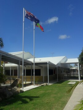
Andergrove State School, 2011.jpg
Andergrove State School, 2011
Australia Queensland location map.svg
Red pog.svg
Andergrove
Andergrove, Queensland
Coordinates 21°05′35″S149°11′08″E / 21.0930°S 149.1855°E / -21.0930; 149.1855 (Andergrove (centre of locality))
Population9,924 (2021 census) [1]
 • Density1,168/km2 (3,024/sq mi)
Postcode(s) 4740
Area8.5 km2 (3.3 sq mi)
Time zone AEST (UTC+10:00)
Location
LGA(s) Mackay Region
State electorate(s) Mackay
Federal division(s) Dawson
Suburbs around Andergrove:
Blacks Beach Blacks Beach Slade Point
Beaconsfield Andergrove Mackay Harbour
Mount Pleasant North Mackay North Mackay

Andergrove is a northern urban locality in Mackay in the Mackay Region, Queensland, Australia. [2] In the 2021 census, Andergrove had a population of 9,924 people. [1]

Contents

Geography

Andergrove has been steadily growing as a suburban community since 1990s and the housing stock is mostly low-set brick homes. [3]

History

Andergrove State School opened on 21 February 1939. [4]

Pioneer State High School opened on 28 January 1986. At that time, Andergrove was in the Pioneer Shire, which was amalgamated into City of Mackay in 1994. [4] [5]

MacKillop Catholic Primary School opened in 1995. [6]

Demographics

In the 2011 census, Andergove had a population of 9,372 people. [7]

In the 2016 census, Andergrove had a population of 9,419 people. [8]

In the 2021 census, Andergrove had a population of 9,924 people. [1]

Education

Andergrove State School is a government primary (Prep-6) school for boys and girls at Fernleigh Avenue ( 21°05′10″S149°11′18″E / 21.0862°S 149.1882°E / -21.0862; 149.1882 (Andergrove State School) ). [9] [10] In 2017, the school had an enrolment of 368 students with 35 teachers (27 full-time equivalent) and 22 non-teaching staff (14 full-time equivalent). [11] It includes a special education program. [9]

MacKillop Catholic Primary School is a Catholic primary (Prep-6) school for boys and girls at 20 Nadarmi Drive ( 21°04′52″S149°11′08″E / 21.0811°S 149.1855°E / -21.0811; 149.1855 (MacKillop Catholic Primary School) ). [9] [12] In 2017, the school had an enrolment of 234 students with 17 teachers (15 full-time equivalent) and 13 non-teaching staff (8 full-time equivalent). [11]

Pioneer State High School is a government secondary (7-12) school for boys and girls at Bedford Road ( 21°05′45″S149°10′50″E / 21.0958°S 149.1806°E / -21.0958; 149.1806 (Pioneer State High School) ). [9] [13] In 2017, the school had an enrolment of 560 students with 56 teachers (51 full-time equivalent) and 34 non-teaching staff (27 full-time equivalent). [11] It includes a special education program. [9] [14]

Amenities

Northside Mackay Uniting Church is at 244-246 Bedford Road ( 21°05′32″S149°10′54″E / 21.0921°S 149.1817°E / -21.0921; 149.1817 (Northside Mackay Uniting Church) ). [15] [16]

Mackay Church of Christ is at 65 Beaconsfield Rd East ( 21°06′33″S149°10′26″E / 21.1093°S 149.1739°E / -21.1093; 149.1739 (Mackay Church of Christ) ). [17] [18] [19]

Related Research Articles

<span class="mw-page-title-main">Sarina, Queensland</span> Town in Queensland, Australia

Sarina is a rural town and coastal locality in the Mackay Region, Queensland, Australia. In the 2021 census, the locality of Sarina had a population of 5,619 people.

<span class="mw-page-title-main">Slade Point, Queensland</span> Town in Queensland, Australia

Slade Point is a coastal town and peninsular suburb in the Mackay Region, Queensland, Australia. In the 2021 census, the suburb of Slade Point had a population of 3,450 people.

<span class="mw-page-title-main">Caboolture, Queensland</span> Town in Queensland, Australia

Caboolture is a town and suburb in the City of Moreton Bay, Queensland, Australia. It is located on the northern side of the Caboolture River. In the 2021 census, the suburb of Caboolture had a population of 29,534 people.

<span class="mw-page-title-main">Highfields, Queensland</span> Town in Queensland, Australia

Highfields is a town and locality in the Toowoomba Region, Queensland, Australia. In the 2021 census, the locality of Highfields had a population of 8,568 people.

<span class="mw-page-title-main">Deception Bay, Queensland</span> Suburb of Moreton Bay, Queensland, Australia

Deception Bay is a coastal suburb in the City of Moreton Bay, Queensland, Australia. In the 2021 census, Deception Bay had a population of 19,573 people.

<span class="mw-page-title-main">Walkerston, Queensland</span> Town in Queensland, Australia

Walkerston is a town and locality in Mackay Region, Queensland, Australia. The town is situated on the Peak Downs Highway 14 kilometres (8.7 mi) south-west of Mackay. In the 2021 census, the locality of Walkerston had a population of 3,615 people.

<span class="mw-page-title-main">Seaforth, Queensland</span> Town in Queensland, Australia

Seaforth is a coastal town and locality in the Mackay Region, Queensland, Australia. In the 2021 census, the locality of Seaforth had a population of 800 people.

Koumala is a rural town and coastal locality in the Mackay Region, Queensland, Australia. In the 2021 census, the locality of Koumala had a population of 772 people.

Beaconsfield is a suburb of Mackay in the Mackay Region, Queensland, Australia. In the 2021 census, Beaconsfield had a population of 5,899 people.

Blacks Beach is a coastal suburb, one of the "northern beaches" of the city of Mackay in the Mackay Region, Queensland, Australia. In the 2021 census, Blacks Beach had a population of 4,153 people.

Rural View is a suburb in the Mackay Region, Queensland, Australia. In the 2021 census, Rural View had a population of 5,657 people.

Glenella is a mixed-use town and suburb of Mackay in the Mackay Region, Queensland, Australia. In the 2021 census, the suburb of Glenella had a population of 4,545 people.

West Mackay is a suburb of Mackay in the Mackay Region, Queensland, Australia. In the 2021 census, West Mackay had a population of 6,536 people.

Mount Pleasant is a suburb in the Mackay Region, Queensland, Australia. In the 2021 census, Mount Pleasant had a population of 4,694 people.

Richmond is a north-western suburb of Mackay in the Mackay Region, Queensland, Australia. In the 2021 census, Richmond had a population of 852 people.

Farleigh is a rural town and locality in the Mackay Region, Queensland, Australia. In the 2021 census, the locality of Farleigh had a population of 814 people.

<span class="mw-page-title-main">North Mackay</span> Suburb of Mackay, Queensland, Australia

North Mackay is a suburb of Mackay in the Mackay Region, Queensland, Australia. In the 2021 census, North Mackay had a population of 6,194 people.

East Mackay is a coastal suburb of Mackay in the Mackay Region, Queensland, Australia. In the 2021 census, East Mackay had a population of 3,725 people.

<span class="mw-page-title-main">South Mackay, Queensland</span> Suburb of Mackay, Queensland, Australia

South Mackay is a coastal suburb of Mackay in the Mackay Region, Queensland, Australia. In the 2021 census, South Mackay had a population of 6,918 people.

Mackay is the central suburb and the central business district of the City of Mackay in the Mackay Region, Queensland, Australia. In the 2021 census, the suburb of Mackay had a population of 4,026 people.
References

  1. 1 2 3 Australian Bureau of Statistics (28 June 2022). "Andergrove (SAL)". 2021 Census QuickStats. Retrieved 28 February 2023. OOjs UI icon edit-ltr-progressive.svg
  2. "Andergrove – locality in Mackay Region (entry 46754)". Queensland Place Names. Queensland Government . Retrieved 5 November 2019.
  3. "Andergrove". Suburbs and parks. Mackay Regional Council. Archived from the original on 16 March 2014. Retrieved 16 March 2014.
  4. 1 2 "Opening and closing dates of Queensland Schools". Queensland Government . Retrieved 27 May 2016.
  5. "Andergrove". Queensland Places. Centre for the Government of Queensland, University of Queensland. Archived from the original on 16 March 2014. Retrieved 15 March 2014.
  6. Queensland Family History Society (2010), Queensland schools past and present (Version 1.01 ed.), Queensland Family History Society, ISBN   978-1-921171-26-0
  7. Australian Bureau of Statistics (31 October 2012). "Andergrove(SSC)". 2011 Census QuickStats. Retrieved 28 May 2016. OOjs UI icon edit-ltr-progressive.svg
  8. Australian Bureau of Statistics (27 June 2017). "Andergrove (SSC)". 2016 Census QuickStats. Retrieved 20 October 2018. OOjs UI icon edit-ltr-progressive.svg
  9. 1 2 3 4 5 "State and non-state school details". Queensland Government. 9 July 2018. Archived from the original on 21 November 2018. Retrieved 21 November 2018.
  10. "Andergrove State School". Archived from the original on 17 March 2021. Retrieved 25 March 2021.
  11. 1 2 3 "ACARA School Profile 2017". Archived from the original on 22 November 2018. Retrieved 22 November 2018.
  12. "MacKillop Catholic Primary School". Archived from the original on 4 February 2014. Retrieved 25 March 2021.
  13. "Pioneer State High School". Archived from the original on 10 March 2021. Retrieved 25 March 2021.
  14. "Pioneer SHS - Special Education Program". Archived from the original on 10 March 2021. Retrieved 25 March 2021.
  15. "Northside Mackay & Seaforth Uniting Church". Archived from the original on 4 March 2021. Retrieved 27 August 2021.
  16. "Find a church". Uniting Church in Australia, Queensland Synod. Archived from the original on 24 October 2020. Retrieved 6 May 2021.
  17. "Mackay Church of Christ". Mackay Church of Christ. Archived from the original on 11 February 2022. Retrieved 2 March 2022.
  18. Blake, Thom. "Mackay Church of Christ". Queensland religious places database. Archived from the original on 2 March 2022. Retrieved 2 March 2022.
  19. Google (2 March 2022). "Mackay Church of Christ" (Map). Google Maps . Google. Retrieved 2 March 2022.