St Helens Beach, Queensland

Last updated

St Helens Beach
Queensland
Australia Queensland location map.svg
Red pog.svg
St Helens Beach
Coordinates 20°50′09″S148°50′26″E / 20.8358°S 148.8405°E / -20.8358; 148.8405 (St Helens Beach (town centre))
Population197 (2016 census locality) [1]
 • Density5.038/km2 (13.05/sq mi)
Postcode(s) 4798
Area39.1 km2 (15.1 sq mi)
Time zone AEST (UTC+10:00)
LGA(s) Mackay Region
State electorate(s) Whitsunday
Federal division(s) Dawson
Localities around St Helens Beach:
Mentmore Mentmore Coral Sea
Pindi Pindi St Helens Beach Coral Sea
Calen Calen Coral Sea

St Helens Beach is a coastal town and locality in the Mackay Region, Queensland, Australia. [2] [3] In the 2016 census the locality of St Helens Beach had a population of 197 people. [1]

Contents

History

Yuwibara (also known as Yuibera, Yuri, Juipera, Yuwiburra) is an Australian Aboriginal language spoken on Yuwibara country. It is closely related to the Biri languages/dialects. The Yuwibara language region includes the landscape within the local government boundaries of the Mackay Region. [4]

Giya (also known as Kia) is a language of North Queensland. The Giya language region includes the landscape within the local government boundaries of the Whitsunday Regional Council, particularly the towns of Bowen and Proserpine. [5]

The town was originally known as Wootaroo but was changed to St Helens by the Queensland Place Names Board on 1 April 1973 and then changed from St Helens to St Helens Beach on 2 September 1989. St Helens was the name of a pastoral run founed by pastoralists R. W. Graham and brothers John and William Macartney in the 1870s. [6] The word beach is a reference to the sandy beach along the coastline of the Coral Sea. [2]

In the 2016 census the locality of St Helens Beach had a population of 197 people. [1]

Related Research Articles

<span class="mw-page-title-main">Sarina, Queensland</span> Town in Queensland, Australia

Sarina is a rural town and coastal locality in the Mackay Region, Queensland, Australia. In the 2021 census, the locality of Sarina had a population of 5,619 people.

<span class="mw-page-title-main">Weipa</span> Town in Queensland, Australia

Weipa is a coastal mining town in the local government area of Weipa Town in Queensland. It is the largest town on the Cape York Peninsula. It exists because of the enormous bauxite deposits along the coast. The Port of Weipa is mainly involved in exports of bauxite. There are also shipments of live cattle from the port.

<span class="mw-page-title-main">Central Queensland</span> Region in Queensland, Australia

Central Queensland is an imprecisely-defined geographical division of Queensland that centres on the eastern coast, around the Tropic of Capricorn. Its major regional centre is Rockhampton. The region extends from the Capricorn Coast west to the Central Highlands at Emerald, north to the Mackay Regional Council southern boundary, and south to Gladstone. The region is also known as Capricornia. It is one of Australia's main coal exporting regions.

<span class="mw-page-title-main">Shire of Balonne</span> Local government area in Queensland, Australia

The Shire of Balonne is a local government area in South West Queensland, Australia, over 500 kilometres (310 mi) from the state capital, Brisbane. It covers an area of 31,104 square kilometres (12,009.3 sq mi), and has existed as a local government entity since 1879. It is headquartered in its main town, St George.

<span class="mw-page-title-main">North Queensland</span> Region in Queensland, Australia

North Queensland or the Northern Region is the northern part of the Australian state of Queensland that lies just south of Far North Queensland. Queensland is a massive state, larger than many countries, and its tropical northern part has been historically remote and undeveloped, resulting in a distinctive regional character and identity.

<span class="mw-page-title-main">Shire of Diamantina</span> Local government area in Queensland, Australia

The Shire of Diamantina is a local government area in Central West Queensland, bordering South Australia and the Northern Territory. Its administrative centre is in the town of Bedourie.

<span class="mw-page-title-main">Shire of Cook</span> Local government area in Queensland, Australia

The Shire of Cook is a local government area in Far North Queensland, Australia. The Shire covers most of the eastern and central parts of Cape York Peninsula, the most northerly section of the Australian mainland.

<span class="mw-page-title-main">Central Highlands Region</span> Local government area in Queensland, Australia

Central Highlands Region is a local government area in Queensland, Australia.

<span class="mw-page-title-main">Mackay Region</span> Local government area in Queensland, Australia

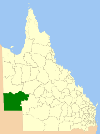
The Mackay Region is a local government area located in North Queensland, Queensland, Australia. Established in 2008, it was preceded by three previous local government areas with modern histories extending back as far as 1869.

<span class="mw-page-title-main">Mirani, Queensland</span> Town in Queensland, Australia

Mirani is a rural town and locality in the Mackay Region, Queensland, Australia. In the 2016 census, the locality of Mirani had a population of 1,541 people.

Biri, also known as Biria, Birri Gubba, Birigaba, Wiri, Perembba and other variants, is an Australian Aboriginal language of the Mackay area of Queensland spoken by the Birri Gubba people. There are at least eight languages regarded as dialects of Biri, and two which are related but whose status is not yet fully determined. All are covered in this article.

<span class="mw-page-title-main">Western Queensland</span> Region in Queensland, Australia

Western Queensland encompasses the three western regions in the Australian state of Queensland:

<span class="mw-page-title-main">Palmer, Queensland</span> Suburb of Shire of Cook, Queensland, Australia

Palmer is a rural locality in the Shire of Cook, Queensland, Australia. In the 2021 census, Palmer had a population of 46 people.

Edward River is a rural locality in the Shire of Cook, Queensland, Australia. In the 2016 census Edward River had a population of 0 people.

<span class="mw-page-title-main">Mossman River</span> River in Far North Queensland, Australia

The Mossman River is a river in the Cape York Peninsula of Far North Queensland, Australia.

<span class="mw-page-title-main">Murray Upper, Queensland</span> Suburb of Cassowary Coast Region, Queensland, Australia

Murray Upper is a rural locality in the Cassowary Coast Region, Queensland, Australia. In the 2016 census Murray Upper had a population of 266 people.

<span class="mw-page-title-main">Dutton River</span> Suburb of Shire of Flinders, Queensland, Australia

Dutton River is a rural locality in the Flinders Shire, Queensland, Australia. In the 2016 census, Dutton River had a population of 33 people.

Mission River is a coastal rural locality split between the Shire of Cook and the Aboriginal Shire of Napranum in Queensland, Australia. In the 2016 census, Mission River had a population of 987 people.

Hidden Valley is a rural locality in the Livingstone Shire, Queensland, Australia. In the 2016 census, Hidden Valley had a population of 421 people.

Mount Mulgrave is a rural locality in the Shire of Mareeba, Queensland, Australia. In the 2016 census, Mount Mulgrave had a population of 0 people.

References

  1. 1 2 3 Australian Bureau of Statistics (27 June 2017). "St Helens Beach (SSC)". 2016 Census QuickStats. Retrieved 20 October 2018. OOjs UI icon edit-ltr-progressive.svg
  2. 1 2 "St Helens Beach – town in Mackay Region (entry 40893)". Queensland Place Names. Queensland Government . Retrieved 27 December 2020.
  3. "St Helens Beach – locality in Mackay Region (entry 46841)". Queensland Place Names. Queensland Government . Retrieved 27 December 2020.
  4. CC BY icon-80x15.png This Wikipedia article incorporates CC-BY-4.0 licensed text from: "Yuwibara". Queensland Aboriginal and Torres Strait Islander languages map. State Library of Queensland . Retrieved 23 January 2020.
  5. CC BY icon-80x15.png This Wikipedia article incorporates CC-BY-4.0 licensed text from: "Indigenous languages map of Queensland". State Library of Queensland. State Library of Queensland . Retrieved 5 February 2020.
  6. "District Place Names". Daily Mercury . Vol. 56, no. 562. Queensland, Australia. 9 December 1922. p. 8. Retrieved 7 September 2023 via National Library of Australia.