Mount Pleasant, Queensland (Mackay Region)

Last updated

Map all coordinates using: OpenStreetMap  
Download coordinates as: KML
Mount Pleasant
Mackay,  Queensland
Australia Queensland location map.svg
Red pog.svg
Mount Pleasant
Coordinates 21°07′01″S149°09′29″E / 21.1169°S 149.1580°E / -21.1169; 149.1580 (Mount Pleasant (centre of suburb)) Coordinates: 21°07′01″S149°09′29″E / 21.1169°S 149.1580°E / -21.1169; 149.1580 (Mount Pleasant (centre of suburb))
Population4,444 (2016 census) [1]
 • Density1,139/km2 (2,950/sq mi)
Postcode(s) 4740
Area3.9 km2 (1.5 sq mi)
Time zone AEST (UTC+10:00)
Location
LGA(s) Mackay Region
State electorate(s) Mackay
Federal division(s) Dawson
Suburbs around Mount Pleasant:
Richmond Beaconsfield Andergrove
Glenella Mount Pleasant North Mackay
Foulden West Mackay Mackay

Mount Pleasant is a suburb in the Mackay Region, Queensland, Australia. [2] In the 2016 census, Mount Pleasant had a population of 4,444 people. [1]

Contents

Geography

The suburb is bounded by Fursden Creek and the Pioneer River to the south, by Hicks Street and the Bruce Highway to the south-west, by Murrays Road and Pioneer Road to the west, the branch line of North Coast railway line to the Port of Mackay) to the north, and Norris Road and Willetts Road to the east. [3]

Historically farming land, the current land use is almost entirely residential, apart from a parcel of farmland in the north of suburb, to the east of the Mackay Bucasia Road. [3]

History

Northview State School opened on 28 January 1986. [4] [5]

On 11 August 1987 the school building of the closed Mount Pelion State School was relocated to Northview State School in Mount Pleasant but it gradually fell into disrepair. On 24 October 2014 the building was moved to Sarina to be restored as part of the Sarina Tourist Art and Craft Visitor Information Centre in Railway Square. [6] [7] [8]

Emmanuel Catholic School was established in 1983 by the Marist Sisters under the leadership of Sister Joan McBride. Initially a primary school offering Years 1 to 7, in 1984 the school commenced Year 8 education rising to Year 10 in 1986. In 1990 the school was renamed Emmanuel College. In 1996 with an enrolment of over 900 students, the school was split was split into a primary school, Emmanuel Catholic Primary School and a secondary school to Year 12, Holy Spirit College. [5] [9] [10]

In the 2011 census, Mount Pleasant had a population of 4,751 people. [11]

In the 2016 census, Mount Pleasant had a population of 4,444 people. [1]

Education

Northview State School is a government primary (Prep-6) school for boys and girls at 54 Pioneer Street ( 21°06′35″S149°09′03″E / 21.1098°S 149.1509°E / -21.1098; 149.1509 (Northview State School) ). [12] [13] In 2018, the school had an enrolment of 393 students with 34 teachers (28 full-time equivalent) and 32 non-teaching staff (18 full-time equivalent). [14] It includes a special education program. [12]

Emmanuel Catholic Primary School is a Catholic primary (Prep-6) school for boys and girls at Baxter Drive ( 21°06′39″S149°09′26″E / 21.1107°S 149.1572°E / -21.1107; 149.1572 (Emmanuel Catholic Primary School) ). [12] [15] In 2018, the school had an enrolment of 576 students with 32 teachers (30 full-time equivalent) and 25 non-teaching staff (13 full-time equivalent). [14]

Holy Spirit College is a Catholic secondary (7-12) school for boys and girls at Baxter Drive ( 21°06′37″S149°09′27″E / 21.1103°S 149.1574°E / -21.1103; 149.1574 (Holy Spirit College) ). [12] [16] In 2018, the school had an enrolment of 810 students with 65 teachers (63 full-time equivalent) and 49 non-teaching staff (36 full-time equivalent). [14]

There is no government secondary school in Mount Pleasant. The nearest government secondary school is Mackay North State High School in neighbouring North Mackay to the east. [3]

Amenities

Mount Pleasant Shopping Centre is a shopping mall on Mackay Bucasia Road between Phillip Street and Malcomson Street ( 21°07′07″S149°09′33″E / 21.1186°S 149.1591°E / -21.1186; 149.1591 (Mount Pleasant Shopping Centre) ). Its anchor tenants are the supermarkets Coles and Woolworths and the discount store KMart, with over 70 speciality stores. [17]

The Mackay Regional Council operates the Gordon White library at 54 Phillip Street ( 21°07′02″S149°09′36″E / 21.1173°S 149.1601°E / -21.1173; 149.1601 (Gordon White public library) ). [18]

Mackay Private Hospital is at 57 Norris Road ( 21°06′49″S149°10′02″E / 21.1137°S 149.1673°E / -21.1137; 149.1673 (Mackay Private Hospital) ). [19]

Carlyle Gardens Mackay is a 16.74-hectare (41.4-acre) retirement village at 206 Phillips Street ( 21°06′41″S149°10′02″E / 21.1114°S 149.1673°E / -21.1114; 149.1673 (Carlyle Gardens retirement village) ). [20]

Related Research Articles

Sarina, Queensland Town in Queensland, Australia

Sarina is a rural town and coastal locality in the Mackay Region, Queensland, Australia. In the 2016 census, Sarina had a population of 5,522 people.

Bray Park, Queensland Suburb of Moreton Bay, Queensland, Australia

Bray Park is a suburb in the Moreton Bay Region, Queensland, Australia. In the 2016 census Bray Park had a population of 10,246 people.

Carmila, Queensland Town in Queensland, Australia

Carmila is a rural town and coastal locality in the Isaac Region, Queensland, Australia. In the 2016 census, the locality of Carmila had a population of 333 people.

Walkerston, Queensland Town in Queensland, Australia

Walkerston is a town and locality in Mackay Region, Queensland, Australia. The town is situated on the Peak Downs Highway 14 kilometres (8.7 mi) south-west of Mackay. In the 2016 census, Walkerston had a population of 3,403 people.

Cranbrook, Queensland Suburb of Townsville, Queensland, Australia

Cranbrook is a suburb of Townsville in the City of Townsville, Queensland, Australia. In the 2016 census, Cranbrook had a population of 5,908 people.

Homebush, Queensland Town in Queensland, Australia

Homebush is a rural locality in the Mackay Region, Queensland, Australia. In the 2016 census Homebush had a population of 271 people.

Koumala, Queensland Town in Queensland, Australia

Koumala is a rural town and coastal locality in the Mackay Region, Queensland, Australia. In the 2016 census, the locality of Koumala had a population of 831 people.

Alligator Creek, Queensland (Mackay) Suburb of Mackay Region, Queensland, Australia

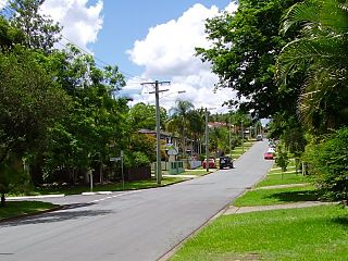
Alligator Creek is a coastal rural locality in the Mackay Region, Queensland, Australia. In the 2016 census, Alligator Creek had a population of 791 people.

Andergrove, Queensland Suburb of Mackay, Queensland, Australia

Andergrove is a northern urban locality in Mackay in the Mackay Region, Queensland, Australia. In the 2016 census, Andergrove had a population of 9,419 people.

Beaconsfield, Queensland Suburb of Mackay, Queensland, Australia

Beaconsfield is a suburb of Mackay in the Mackay Region, Queensland, Australia. In the 2016 census Beaconsfield had a population of 5,490 people.

Bucasia, Queensland Suburb of Mackay, Queensland, Australia

Bucasia is a coastal town and one of the largest suburb of Mackay in the Mackay Region, Queensland, Australia. In the 2016 census the suburb of Bucasia had a population of 4,771 people.

Rural View, Queensland Suburb of Mackay, Queensland, Australia

Rural View is a suburb in the Mackay Region, Queensland, Australia. In the 2016 census, Rural View had a population of 4,793 people.

Glenella, Queensland Suburb of Mackay, Queensland, Australia

Glenella is a mixed-use town and suburb of Mackay in the Mackay Region, Queensland, Australia. In the 2016 census, Glenella had a population of 4,519 people.

Richmond, Queensland (Mackay Region) Suburb of Mackay, Queensland, Australia

Richmond is a suburb of Mackay in the Mackay Region, Queensland, Australia. In the 2016 census Richmond had a population of 486 people.

Oakenden, Queensland Suburb of Mackay Region, Queensland, Australia

Oakenden is a rural locality in the Mackay Region, Queensland, Australia. In the 2016 census, Oakenden had a population of 431 people.

Chelona, Queensland Suburb of Mackay Region, Queensland, Australia

Chelona is a rural locality in the Mackay Region, Queensland, Australia. In the 2016 census, Chelona had a population of 100 people.

Farleigh, Queensland Town in Queensland, Australia

Farleigh is a rural town and locality in the Mackay Region, Queensland, Australia. In the 2016 census the locality of Farleigh had a population of 815 people.

East Mackay, Queensland Suburb of Mackay, Queensland, Australia

East Mackay is a coastal suburb of Mackay in the Mackay Region, Queensland, Australia. In the 2016 census, East Mackay had a population of 3,564 people.

Mount Pelion, Queensland Suburb of Mackay Region, Queensland, Australia

Mount Pelion is a rural locality in the Mackay Region, Queensland, Australia. In the 2016 census Mount Pelion had a population of 125 people.

Mackay (suburb), Queensland Suburb of Mackay, Queensland, Australia

Mackay is the central suburb of the city of Mackay in the Mackay Region, Queensland, Australia. In the 2016 census, the suburb of Mackay had a population of 3,659 people.

References

  1. 1 2 3 Australian Bureau of Statistics (27 June 2017). "Mount Pleasant (SSC)". 2016 Census QuickStats. Retrieved 20 October 2018. OOjs UI icon edit-ltr-progressive.svg
  2. "Mount Pleasant – suburb in Mackay Region (entry 46814)". Queensland Place Names. Queensland Government . Retrieved 27 December 2020.
  3. 1 2 3 "Queensland Globe". State of Queensland . Retrieved 22 January 2022.
  4. "Opening and closing dates of Queensland Schools". Queensland Government . Retrieved 18 April 2019.
  5. 1 2 Queensland Family History Society (2010), Queensland schools past and present (Version 1.01 ed.), Queensland Family History Society, ISBN   978-1-921171-26-0
  6. Zakilew, D.C. (24 October 2014). "Old school building moves on". Mackay Daily Mercury (in Australian English). Archived from the original on 13 October 2020. Retrieved 19 January 2021.
  7. "The perils of school at Pelion". Mackay Daily Mercury . 24 February 2018. Archived from the original on 24 February 2018. Retrieved 19 January 2021.
  8. "The Sarina Arts & Crafts Centre". Mackay Regional Council (in Australian English). 12 May 2015. Archived from the original on 3 December 2020. Retrieved 19 January 2021.
  9. "School History". Emmanuel Primary School Mackay. Archived from the original on 22 January 2022. Retrieved 22 January 2022.
  10. "College History". Holy Spirit College Mackay (in American English). Archived from the original on 22 January 2022. Retrieved 22 January 2022.
  11. Australian Bureau of Statistics (31 October 2012). "Mount Pleasant". 2011 Census QuickStats. Retrieved 4 January 2016. OOjs UI icon edit-ltr-progressive.svg
  12. 1 2 3 4 "State and non-state school details". Queensland Government. 9 July 2018. Archived from the original on 21 November 2018. Retrieved 21 November 2018.
  13. "Northview State School". Northview State School. 20 November 2019. Archived from the original on 10 March 2021. Retrieved 22 January 2022.
  14. 1 2 3 "ACARA School Profile 2018". Australian Curriculum, Assessment and Reporting Authority. Archived from the original on 27 August 2020. Retrieved 28 January 2020.
  15. "Emmanuel Catholic Primary School". Archived from the original on 8 November 2018. Retrieved 21 November 2018.
  16. "Holy Spirit College". Archived from the original on 11 January 2019. Retrieved 21 November 2018.
  17. "Mount Pleasant Shopping Centre". Tourism & Events Queensland. Archived from the original on 22 January 2022. Retrieved 23 January 2022.
  18. "Libraries: Contact/Opening Hours". Mackay Regional Council. Archived from the original on 1 March 2016. Retrieved 28 April 2017.
  19. "Homepage". Mackay Private Hospital. 22 January 2022. Archived from the original on 20 January 2022. Retrieved 22 January 2022.
  20. "Mackay". Carlyle Gardens. Archived from the original on 4 January 2022. Retrieved 22 January 2022.