Glenella, Queensland

Last updated

Glenella
Mackay,  Queensland
Australia Queensland location map.svg
Red pog.svg
Glenella
Glenella, Queensland
Coordinates 21°07′11″S149°09′16″E / 21.1198°S 149.1544°E / -21.1198; 149.1544 (Glenella (town centre))
Population4,545 (2021 census) [1]
 • Density420.8/km2 (1,090/sq mi)
Postcode(s) 4740
Elevation10–60 m (33–197 ft)
Area10.8 km2 (4.2 sq mi)
Time zone AEST (UTC+10:00)
Location
LGA(s) Mackay Region
State electorate(s)
Federal division(s) Dawson
Localities around Glenella:
Farleigh Richmond Richmond
Farleigh Glenella Mount Pleasant
Erakala Erakala Foulden

Glenella is a mixed-use town and suburb of Mackay in the Mackay Region, Queensland, Australia. [2] [3] In the 2021 census, the locality of Glenella had a population of 4,545 people. [1]

Contents

Geography

The land is mostly low-lying 10 metres (33 ft) or less above sea level but with some hills rising to 60 metres (200 ft). [4]

The land in the east and south-east of the suburb is residential. There is a small industrial estate in the south-east. The remainder of the suburb remains rural, mostly growing sugarcane and some grazing on native vegetation. [4]

The Bruce Highway passes through the suburb from the east (Mount Pleasant) to the west (Farleigh). The North Coast railway line enters the suburb from the north-east (Richmond) and exits to the west (Farleigh). There is a network of cane tramways through the suburb operated by Mackay Sugar to deliver the harvested sugarcane to the sugar mills, the nearest being Farleigh mill in Farleigh. [4]

History

Mackay North State School opened on 3 February 1879 with an initial enrolment of 35 children. The first teacher was Daniel Shea. It was renamed Glenella State School on 1 April 1912. The school was so badly damaged in the 1918 Mackay cyclone that it was completely rebuilt. [5] [6] [7] (It should not be confused with the current Mackay North State School in North Mackay which opened in 1915).

Glenella Hall opened on Saturday 8 October 1938 with a dance to raise funds for the Mackay Ambulance. Over 300 people attended. The owner of the hall was Ted Jackson and it was located next door to his Glenalla Hotel on the corner of Hill End Road and Davey Street. The hotel was demolished in circa 1980. [8] [9]

Demographics

In the 2011 census, the locality of Glenella had a population of 4,633 people. [10]

In the 2016 census, the locality of Glenella had a population of 4,519 people. [11]

In the 2021 census, the locality of Glenella had a population of 4,545 people. [1]

Education

Glenella State School is a government primary (Prep-6) school for boys and girls at 35-55 Hill End Road ( 21°07′17″S149°08′57″E / 21.1214°S 149.1493°E / -21.1214; 149.1493 (Glenella State School) ). [12] [13] In 2018, the school had an enrolment of 189 students with 15 teachers (12 full-time equivalent) and 11 non-teaching staff (7 full-time equivalent). [14] It includes a special education program. [12]

There is no secondary school in Glenella. The nearest secondary schools are Mackay North State High School in North Mackay to the south-east and Pioneer State High School in Andergrove to the north-east. [4]

Amenities

Glenella Community Hall is at 15 Hill End Road ( 21°07′07″S149°08′45″E / 21.1187°S 149.1459°E / -21.1187; 149.1459 (Glenella Community Hall) ). It is operated by the Mackay Regional Council. [15]

Related Research Articles

<span class="mw-page-title-main">Calen, Queensland</span> Town in Queensland, Australia

Calen is a rural town and coastal locality in the Mackay Region, Queensland, Australia. In the 2016 census, the locality of Calen had a population of 390 people.

<span class="mw-page-title-main">Mount Coolum, Queensland</span> Suburb of Sunshine Coast, Queensland, Australia

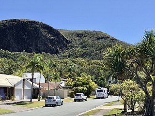
Mount Coolum is a coastal suburb in the Sunshine Coast Region, Queensland, Australia. In the 2021 census, Mount Coolum had a population of 4,545 people.

Te Kowai is a rural locality in the Mackay Region, Queensland, Australia. In the 2021 census, Te Kowai had a population of 227 people.

The Leap is a coastal rural locality in the Mackay Region, Queensland, Australia. In the 2021 census, The Leap had a population of 664 people.

Bucasia is a coastal town and suburb of Mackay in the Mackay Region, Queensland, Australia. In the 2021 census, the suburb of Bucasia had a population of 4,915 people.

<span class="mw-page-title-main">Alexandra, Queensland</span> Suburb of Mackay, Queensland, Australia

Alexandra is a suburb of Mackay in the Mackay Region, Queensland, Australia. In the 2021 census, Alexandra had a population of 189 people.

<span class="mw-page-title-main">Habana, Queensland</span> Suburb of Mackay Region, Queensland, Australia

Habana is a coastal rural locality in the Mackay Region, Queensland, Australia. In the 2021 census, Habana had a population of 1,022 people.

West Mackay is a suburb of Mackay in the Mackay Region, Queensland, Australia. In the 2021 census, West Mackay had a population of 6,536 people.

Shoal Point is a coastal suburb in the Mackay Region, Queensland, Australia. In the 2021 census, Shoal Point had a population of 1,104 people.

McEwens Beach is a coastal town and rural locality in the Mackay Region, Queensland, Australia. In the 2016 census, the locality of McEwens Beach recorded a population of 202 people.

Farleigh is a rural town and locality in the Mackay Region, Queensland, Australia. In the 2016 census the locality of Farleigh had a population of 815 people.

Ooralea is a southern suburb of Mackay in the Mackay Region, Queensland, Australia. In the 2021 census, Ooralea had a population of 3,691 people.

East Mackay is a coastal suburb of Mackay in the Mackay Region, Queensland, Australia. In the 2021 census, East Mackay had a population of 3,725 people.

<span class="mw-page-title-main">Mackay Harbour, Queensland</span> Suburb of Mackay, Queensland, Australia

Mackay Harbour is a coastal mixed-use locality in the Mackay Region, Queensland, Australia. In the 2021 census, Mackay Harbour had a population of 686 people.

Campwin Beach is a coastal town and rural locality in the Mackay Region, Queensland, Australia. In the 2016 census, Campwin Beach had a population of 517 people.

<span class="mw-page-title-main">Foulden, Queensland</span> Suburb of Mackay, Queensland, Australia

Foulden is a rural locality in the Mackay Region, Queensland, Australia. It is on the northern bank of the Pioneer River in Mackay. In the 2021 census, Foulden had "no people or a very low population".

Dunnrock is a coastal rural locality in the Mackay Region, Queensland, Australia. In the 2021 census, Dunnrock had a population of 58 people.

<span class="mw-page-title-main">Dolphin Heads, Queensland</span> Town in Queensland, Australia

Dolphin Heads is a coastal town and northern suburb of Mackay in the Mackay Region, Queensland, Australia. In the 2021 census, the suburb of Dolphin Heads had a population of 413 people.

Erakala is a mixed-use locality in the Mackay Region, Queensland, Australia. In the 2021 census, Erakala had a population of 763 people.

Mackay is the central suburb and the central business district of the City of Mackay in the Mackay Region, Queensland, Australia. In the 2021 census, the suburb of Mackay had a population of 4,026 people.

References

  1. 1 2 3 Australian Bureau of Statistics (28 June 2022). "Glenella (SAL)". 2021 Census QuickStats. Retrieved 28 February 2023. OOjs UI icon edit-ltr-progressive.svg
  2. "Glenella – town in Mackay Region (entry 13965)". Queensland Place Names. Queensland Government . Retrieved 18 September 2020.
  3. "Glenella – suburb in Mackay Region (entry 49375)". Queensland Place Names. Queensland Government . Retrieved 18 September 2020.
  4. 1 2 3 4 "Queensland Globe". State of Queensland . Retrieved 30 October 2020.
  5. "Opening and closing dates of Queensland Schools". Queensland Government . Retrieved 18 April 2019.
  6. "Glenella State School". Glenella State School. Archived from the original on 3 February 2018. Retrieved 3 February 2018.
  7. "History". Glenella State School. 22 December 2019. Archived from the original on 30 October 2020. Retrieved 30 October 2020.
  8. "New Hall Opened". Daily Mercury . Vol. 72, no. 243. Queensland, Australia. 12 October 1938. p. 8. Archived from the original on 13 June 2022. Retrieved 31 October 2020 via National Library of Australia.
  9. "Hotels of Mackay, Listing A to K". Mackay History. Archived from the original on 16 February 2020. Retrieved 30 October 2020.
  10. Australian Bureau of Statistics (31 October 2012). "Glenella". 2011 Census QuickStats. Retrieved 4 January 2016. OOjs UI icon edit-ltr-progressive.svg
  11. Australian Bureau of Statistics (27 June 2017). "Glenella (SSC)". 2016 Census QuickStats. Retrieved 20 October 2018. OOjs UI icon edit-ltr-progressive.svg
  12. 1 2 "State and non-state school details". Queensland Government. 9 July 2018. Archived from the original on 21 November 2018. Retrieved 21 November 2018.
  13. "Glenella State School". Archived from the original on 28 March 2020. Retrieved 21 November 2018.
  14. "ACARA School Profile 2018". Australian Curriculum, Assessment and Reporting Authority. Archived from the original on 27 August 2020. Retrieved 28 January 2020.
  15. "Glenella Community Hall". Mackay Regional Council . 8 April 2020. Archived from the original on 30 October 2020. Retrieved 30 October 2020.