Rosella, Queensland

Last updated

Rosella
Queensland
Australia Queensland location map.svg
Red pog.svg
Rosella
Coordinates 21°14′33″S149°08′43″E / 21.2425°S 149.1452°E / -21.2425; 149.1452
Population78 (2021 census) [1]
 • Density9.18/km2 (23.77/sq mi)
Postcode(s) 4740
Area8.5 km2 (3.3 sq mi)
Time zone AEST (UTC+10:00)
LGA(s) Mackay Region
State electorate(s) Mirani
Federal division(s) Capricornia
Suburbs around Rosella:
Bakers Creek Bakers Creek Bakers Creek
Sandiford Rosella McEwens Beach
Chelona Chelona Chelona

Rosella is a rural locality in the Mackay Region, Queensland, Australia. [2] In the 2021 census, Rosella had a population of 78 people. [1]

Contents

Geography

The Bruce Highway enters the locality from the south (Chelona) and exits to north (Bakers Creek). [3] The North Coast railway line enters the locality from the south-west (Chelona) and exits to the north-west (Bakers Creek) with Rosella railway station serving the locality ( 21°14′24″S149°08′21″E / 21.2399°S 149.1391°E / -21.2399; 149.1391 (Rosella railway station) ). [4]

The land use is predominantly growing sugarcane. [5] There is a cane tramway network to transport the harvested sugarcane to the local sugar mill. [4] [6]

Demographics

In the 2016 census, Rosella had a population of 85 people. [7]

In the 2021 census, Rosella had a population of 78 people. [1]

Education

There are no schools in Rosella. The nearest government primary school is Chelona State School in neighbouring Chelona to the south. The nearest government secondary school is Mackay State High School in South Mackay to the north. There are also non-government schools in Mackay. [8]

Related Research Articles

Bakers Creek is a rural town and coastal locality in the Mackay Region, Queensland, Australia. In the 2021 census, the locality of Bakers Creek had a population of 1,590 people.

Te Kowai is a rural locality in the Mackay Region, Queensland, Australia. In the 2021 census, Te Kowai had a population of 227 people.

The Leap is a coastal rural locality in the Mackay Region, Queensland, Australia. In the 2021 census, The Leap had a population of 664 people.

<span class="mw-page-title-main">Alexandra, Queensland</span> Suburb of Mackay, Queensland, Australia

Alexandra is a suburb of Mackay in the Mackay Region, Queensland, Australia. In the 2021 census, Alexandra had a population of 189 people.

<span class="mw-page-title-main">Pleystowe, Queensland</span> Suburb of Mackay Region, Queensland, Australia

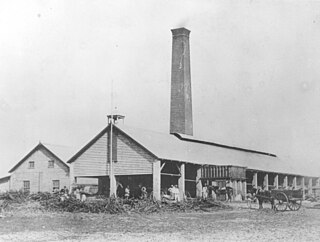
Pleystowe is a rural locality in the Mackay Region, Queensland, Australia. It is known for the former Pleystowe Sugar Mill used to crush sugar cane to produce raw sugar. In the 2021 census, Pleystowe had a population of 418 people.

<span class="mw-page-title-main">Shoal Point, Queensland</span> Suburb of Mackay, Queensland, Australia

Shoal Point is a coastal suburb in the Mackay Region, Queensland, Australia. In the 2021 census, Shoal Point had a population of 1,104 people.

<span class="mw-page-title-main">Chelona, Queensland</span> Suburb of Mackay Region, Queensland, Australia

Chelona is a rural locality in the Mackay Region, Queensland, Australia. In the 2021 census, Chelona had a population of 120 people.

McEwens Beach is a coastal town and rural locality in the Mackay Region, Queensland, Australia. In the 2021 census, the locality of McEwens Beach had a population of 159 people.

Mount Pelion is a rural locality in the Mackay Region, Queensland, Australia. In the 2021 census, Mount Pelion had a population of 90 people.

Munbura is a rural locality in the Mackay Region, Queensland, Australia. In the 2021 census, Munbura had a population of 89 people.

<span class="mw-page-title-main">Nindaroo</span> Suburb of Mackay Region, Queensland, Australia

Nindaroo is a rural locality in the Mackay Region, Queensland, Australia. In the 2021 census, Nindaroo had a population of 255 people.

Sandiford is a rural locality in the Mackay Region, Queensland, Australia. In the 2021 census, Sandiford had a population of 168 people.

<span class="mw-page-title-main">Foulden, Queensland</span> Suburb of Mackay, Queensland, Australia

Foulden is a rural locality in the Mackay Region, Queensland, Australia. It is on the northern bank of the Pioneer River in Mackay. In the 2021 census, Foulden had "no people or a very low population".

Dunnrock is a coastal rural locality in the Mackay Region, Queensland, Australia. In the 2021 census, Dunnrock had a population of 58 people.

Vasa Views is a locality in the Cassowary Coast Region, Queensland, Australia. In the 2021 census, Vasa Views had a population of 136 people.

Erakala is a mixed-use locality in the Mackay Region, Queensland, Australia. In the 2021 census, Erakala had a population of 763 people.

Pinevale is a rural locality in the Mackay Region, Queensland, Australia. In the 2021 census, Pinevale had a population of 51 people.

<span class="mw-page-title-main">Palmyra, Queensland</span> Suburb of Mackay Region, Queensland, Australia

Palmyra is a rural locality in the Mackay Region, Queensland, Australia. In the 2021 census, Palmyra had a population of 250 people.

<span class="mw-page-title-main">Victoria Plains, Queensland</span> Suburb of Mackay Region, Queensland, Australia

Victoria Plains is a rural locality in the Mackay Region, Queensland, Australia. In the 2021 census, Victoria Plains had a population of 338 people.

Djarawong is a rural locality in the Cassowary Coast Region, Queensland, Australia. In the 2021 census, Djarawong had a population of 103 people.

References

  1. 1 2 3 Australian Bureau of Statistics (28 June 2022). "Rosella (SAL)". 2021 Census QuickStats. Retrieved 28 February 2023. OOjs UI icon edit-ltr-progressive.svg
  2. "Rosella – locality in Mackay Region (entry 46830)". Queensland Place Names. Queensland Government . Retrieved 29 October 2019.
  3. "Rosella, Queensland" (Map). Google Maps . Retrieved 20 August 2021.
  4. 1 2 "Railway stations and sidings - Queensland". Queensland Open Data. Queensland Government. 2 October 2020. Archived from the original on 5 October 2020. Retrieved 5 October 2020.
  5. "Layers: Locality; Protected areas and forests; Land use; Sugarcane areas". Queensland Globe. Queensland Government. Archived from the original on 19 December 2017. Retrieved 31 December 2024.
  6. "Layers: Locality; Road and rail; Railways; Railway stations". Queensland Globe. Queensland Government. Archived from the original on 19 December 2017. Retrieved 31 December 2024.
  7. Australian Bureau of Statistics (27 June 2017). "Rosella (SSC)". 2016 Census QuickStats. Retrieved 20 October 2018. OOjs UI icon edit-ltr-progressive.svg
  8. "Layers: Locality; Schools and school catchments". Queensland Globe. Queensland Government. Archived from the original on 19 December 2017. Retrieved 31 December 2024.