Aboriginal Shire of Woorabinda

Last updated

Aboriginal Shire of Woorabinda
Queensland
Australia Queensland location map.svg
Red pog.svg
Aboriginal Shire of Woorabinda
Coordinates 24°7′S149°27′E / 24.117°S 149.450°E / -24.117; 149.450
Population1,019 (2021 census) [1]
 • Density2.606/km2 (6.750/sq mi)
Area391 km2 (151.0 sq mi) [2]
MayorJoshua Mark Weazel
Council seat Woorabinda
Region Central Queensland
State electorate(s) Gregory
Federal division(s) Flynn
Woorabinda-council.png
Website Aboriginal Shire of Woorabinda
LGAs around Aboriginal Shire of Woorabinda:
Central Highlands Central Highlands Rockhampton
Central Highlands Woorabinda Central Highlands
Central Highlands Central Highlands Central Highlands

The Aboriginal Shire of Woorabinda is a local government area in Central Queensland, Australia. [3]

Contents

In the 2021 census, the Aboriginal Shire of Woorabinda had a population of 1,019 people. [1]

Geography

Most local government areas are a single contiguous area (possibly including islands). However, Aboriginal Shires are often defined as a number of disjoint areas each containing an Indigenous community. In the case of the Aboriginal Shire of Woorabinda, the distinct regions are:

History

Wadja (also known as Wadjigu, Wadya, Wadjainngo, Mandalgu, and Wadjigun) is an Australian Aboriginal language in Central Queensland. The language region includes the local government areas of the Aboriginal Shire of Woorabinda and Central Highlands Region, including the Blackdown Tablelands. the Comet River, and the Expedition Range, and the towns of Woorabinda, Springsure and Rolleston. [10]

Demographics

In the 2016 census, the Aboriginal Shire of Woorabinda had a population of 962 people. [11]

In the 2021 census, the Aboriginal Shire of Woorabinda had a population of 1,019 people. [1]

Amenities

Woorabinda Shire Council operate an Indigenous Knowledge Centre at Woorabinda. [12]

Mayors


2007–present

No.PortraitMayorPartyTerm startTerm endNotes
3x4.svg Lawrence Weazel Independent 2007 3 April 2008 Lost re-election [13]
3x4.svg Roderick William Tobane Independent 3 April 2008 2011Resigned [14]
3x4.svg Christopher Paul Adams Independent 201113 March 2012Removed from office after being jailed for driving while disqualified [15]
3x4.svg Steven Kemp Independent 13 March 2012 28 April 2012 Acting mayor until 2012 election
3x4.svg Terence Munns Independent 28 April 2012 19 March 2016 [16]
3x4.svg Cheyne (Shane) Wilkie Independent 19 March 2016 25 October 2019Resigned amid serious misconduct allegations [17]
3x4.svg Josh Weazel Team Josh Weazel 28 March 2020 2020Lost re-election [18]
Independent 2020 16 March 2024
3x4.svg Terence Munns Independent 16 March 2024 presentIncumbent [19]

Related Research Articles

<span class="mw-page-title-main">Blackdown Tableland National Park</span> Protected area in Queensland, Australia

Blackdown Tableland is a national park in the Central Highlands Region, Queensland, Australia.

<span class="mw-page-title-main">Central Queensland</span> Region in Queensland, Australia

Central Queensland is an imprecisely-defined geographical division of Queensland that centres on the eastern coast, around the Tropic of Capricorn. Its major regional centre is Rockhampton. The region extends from the Capricorn Coast west to the Central Highlands at Emerald, north to the Mackay Regional Council southern boundary, and south to Gladstone. The region is also known as Capricornia. It is one of Australia's main coal exporting regions.

<span class="mw-page-title-main">Rolleston, Queensland</span> Town in Queensland, Australia

Rolleston is a rural town and locality in the Central Highlands Region, Queensland, Australia. In the 2021 census, the locality of Rolleston had a population of 132 people.

<span class="mw-page-title-main">Springsure</span> Town in Queensland, Australia

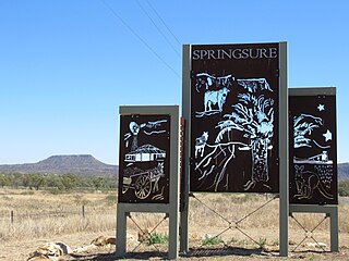
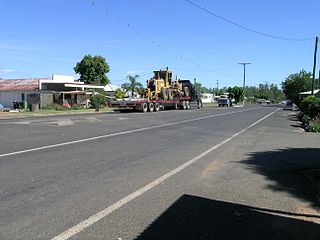
Springsure is a rural town and locality in the Central Highlands Region, Queensland, Australia. In the 2021 census, the locality of Springsure had a population of 950 people.

<span class="mw-page-title-main">Duaringa</span> Town in Queensland, Australia

Duaringa is a rural town in the Central Highlands Region and a locality split between the Central Highlands Region and the Aboriginal Shire of Woorabinda in Central Queensland, Australia. In the 2021 census, the locality of Duaringa had a population of 262 people.

<span class="mw-page-title-main">Shire of Peak Downs</span> Local government area in Queensland, Australia

The Shire of Peak Downs was a local government area in the Central Highlands of Queensland, Australia, 320 km west of both Rockhampton and Mackay. On 15 March 2008 the shires of Duaringa, Emerald, Bauhinia and Peak Downs were amalgamated to form the Central Highlands Region.

<span class="mw-page-title-main">Woorabinda, Queensland</span> Town in Queensland, Australia

Woorabinda is a rural town and locality in the Aboriginal Shire of Woorabinda, Queensland, Australia. It is an Aboriginal community. In the 2021 census, the locality of Woorabinda had a population of 1,019 people with 91.6% identifying as Aboriginal or Torres Strait Islander.

Expedition Range is a mountain range within the Central Highlands sandstone region of Queensland, Australia. Robinson Creek cuts a 100 metres deep gorge through sandstone clifflines. Many spectacular side gorges add to the appeal of the area, which is included in the Expedition National Park.

<span class="mw-page-title-main">Shire of Duaringa</span> Local government area in Queensland, Australia

The Shire of Duaringa was a local government area in the Capricornia region of Queensland, Australia. Duaringa Shire covered an area of 18,201 square kilometres and had a population of 6,744 according to the 2006 census. On 15 March 2008 the shires of Duaringa, Emerald, Bauhinia and Peak Downs were amalgamated to form the Central Highlands Region.

<span class="mw-page-title-main">Shire of Emerald</span> Local government area in Queensland, Australia

The Shire of Emerald is a former local government area in the Central Highlands region of Queensland, Australia. On 15 March 2008 the shires of Duaringa, Emerald, Bauhinia and Peak Downs were amalgamated to form the Central Highlands Region. Its administrative centre is based around Emerald.

<span class="mw-page-title-main">Shire of Bauhinia</span> Local government area in Queensland, Australia

The Shire of Bauhinia was a local government area in Central Queensland, Queensland, Australia. The Shire, administered from the town of Springsure, covered an area of 23,649.6 square kilometres (9,131.2 sq mi), and existed as a local government entity from 1879 until 2008, when it was amalgamated with the Shires of Duaringa, Emerald and Peak Downs to form the Central Highlands Region.

<span class="mw-page-title-main">Central Highlands Region</span> Local government area in Queensland, Australia

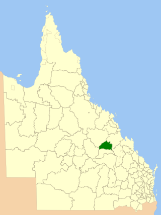
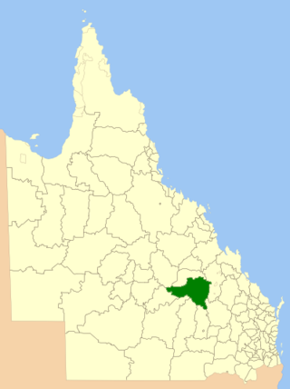
Central Highlands Region is a local government area in Queensland, Australia. In the 2021 census, the Central Highlands Region had a population of 27,836 people.

<span class="mw-page-title-main">Comet River</span> River in Queensland, Australia

The Comet River is a river in Central Queensland, Australia.

<span class="mw-page-title-main">Dingo, Queensland</span> Town in Queensland, Australia

Dingo is a rural town and locality in the Central Highlands Region, Queensland, Australia. In the 2021 census, the locality of Dingo had a population of 221 people.

<span class="mw-page-title-main">Aboriginal Shire of Hope Vale</span> Local government area in Queensland, Australia

The Aboriginal Shire of Hope Vale is a local government area in Far North Queensland, Queensland, Australia, north of the town of Cooktown. The majority of the Shire consists of Deed of Grant land that is held for the benefit of Aboriginal people particularly concerned with the land and their ancestors and descendants.

<span class="mw-page-title-main">Bauhinia, Queensland</span> Town in Queensland, Australia

Bauhinia is a rural town in the Central Highlands Region and a rural locality split between the Central Highlands Region and the Aboriginal Shire of Woorabinda, both in Queensland, Australia. In the 2021 census, the locality of Bauhinia had a population of 28 people.

<span class="mw-page-title-main">Fitzroy Developmental Road</span>

The Fitzroy Developmental Road is a designated road in the Central Highlands Region of Queensland consisting of three separate sections. The general direction is from south to north. It is nicknamed the Beef Road.

Barnard is a rural locality in the Central Highlands Region, Queensland, Australia. In the 2021 census, Barnard had a population of 32 people.

Balcomba is a rural locality split between the Central Highlands Region and the Aboriginal Shire of Woorabinda, Queensland, Australia. In the 2021 census, Balcomba had a population of 29 people.

Wallaroo is a rural locality split between the Central Highlands Region and the Aboriginal Shire of Woorabinda, Queensland, Australia. In the 2021 census, Wallaroo had "no people or a very low population".

References

  1. 1 2 3 Australian Bureau of Statistics (28 June 2022). "Aboriginal Shire of Woorabinda (LGA)". 2021 Census QuickStats. Retrieved 28 February 2023. OOjs UI icon edit-ltr-progressive.svg
  2. "3218.0 – Regional Population Growth, Australia, 2017-18: Population Estimates by Local Government Area (ASGS 2018), 2017 to 2018". Australian Bureau of Statistics. Australian Bureau of Statistics. 27 March 2019. Retrieved 25 October 2019. Estimated resident population, 30 June 2018.
  3. "Local Government (Community Government Areas) Act 2004". Queensland Legislation: In Force. Queensland Government . Retrieved 28 December 2017.
  4. "Balcomba – locality in the Aboriginal Shire of Woorabinda (entry 49301)". Queensland Place Names. Queensland Government . Retrieved 28 December 2017.
  5. "Bauhinia – locality in the Aboriginal Shire of Woorabinda (entry 49303)". Queensland Place Names. Queensland Government . Retrieved 28 December 2017.
  6. "Duaringa – locality in the Aboriginal Shire of Woorabinda (entry 49305)". Queensland Place Names. Queensland Government . Retrieved 28 December 2017.
  7. "Wallaroo – locality in the Aboriginal Shire of Woorabinda (entry 49306)". Queensland Place Names. Queensland Government . Retrieved 28 December 2017.
  8. "Woorabinda – town in the Aboriginal Shire of Woorabinda (entry 38114)". Queensland Place Names. Queensland Government . Retrieved 28 December 2017.
  9. "Woorabinda – locality in the Aboriginal Shire of Woorabinda (entry 49299)". Queensland Place Names. Queensland Government . Retrieved 28 December 2017.
  10. CC BY icon-80x15.png This Wikipedia article incorporates CC BY 4.0 licensed text from: "Wadja". Queensland Aboriginal and Torres Strait Islander languages map. State Library of Queensland . Retrieved 5 February 2020.
  11. Australian Bureau of Statistics (27 June 2017). "Aboriginal Shire of Woorabinda (LGA)". 2016 Census QuickStats. Retrieved 20 October 2018. OOjs UI icon edit-ltr-progressive.svg
  12. "Woorabinda Knowledge Centre". Public Libraries Connect. Woorabinda Shire Council. 31 August 2017. Retrieved 2 February 2018.
  13. "Former mayor takes lead in Woorabinda election race". ABC News. 19 March 2008. Retrieved 6 April 2024.
  14. McDonald, Madeline (8 July 2015). "Ex-mayor of Woorabinda behind bars after all-in brawl". The Morning Bulletin. Retrieved 6 April 2024. Tobane, Mayor of the Woorabinda community from 2008 to 2011...
  15. "Woorabinda mayor removed from office". The Morning Bulletin. 14 March 2012. Retrieved 6 April 2024. Woorabinda Mayor Christopher Paul Adams was yesterday removed from office after his conviction and jail sentence for driving while disqualified... Deputy Mayor Steven Kemp will become acting mayor through to the elections...
  16. "2012 Woorabinda Aboriginal Shire Council - Mayor". Electoral Commission Queensland. 2012. Retrieved 6 April 2024.
  17. Mackay, Pam (24 March 2021). "Former CQ mayor guilty of serious and unacceptable misconduct". The Morning Bulletin. Retrieved 6 April 2024. Mr Wilkie was elected as mayor of the Woorabinda Aboriginal Shire Council in March 2016 and resigned from his position as mayor and councillor effective from October 25, 2019.
  18. "2020 Local Government Elections: Saturday, 28 March 2020". Electoral Commission of Queensland. 2020. Archived from the original on 23 December 2020. Retrieved 16 June 2020.
  19. Furler, Mark (20 March 2024). "Queensland could have 24 new mayors". The Daily Mercury. Retrieved 6 April 2024. Terence Munns looks set to become the next Woorabinda Shire Council mayor, with Joshua Weazel choosing not to run again