The Gemfields is a locality in the Central Highlands Region, Queensland, Australia. In the 2016 census, The Gemfields had a population of 1449 people.

Chillagoe is a town and locality in northern Queensland, Australia. It is within the local government area of Shire of Mareeba. It was once a thriving mining town for a range of minerals, but is now reduced to a small zinc mine and some marble quarries. In the 2011 census, Chillagoe had a population of 192 people.

Capella is a small town and locality in the Central Highlands Region, Queensland, Australia. In the 2016 census, Capella had a population of 1,010 people.

Landsborough is a town and a locality in the Sunshine Coast Region, Queensland, Australia. In the 2016 census, Landsborough had a population of 3,812 people.

Woorabinda is an Aboriginal community in Central Queensland, Australia, inland about two hours' west drive of Rockhampton. At the 2006 census, Woorabinda had a population of 851.

Baralaba is a small town and rural locality in the Shire of Banana in central Queensland, Australia. In the 2016 census, Baralaba had a population of 314 people.

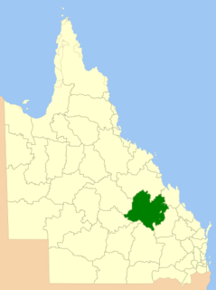
The Shire of Duaringa was a local government area in the Capricornia region of Queensland, Australia. Duaringa Shire covered an area of 18,201 square kilometres and had a population of 6,744 according to the 2006 census. On 15 March 2008 the shires of Duaringa, Emerald, Bauhinia and Peak Downs were amalgamated to form the Central Highlands Region.

Eerwah Vale is a locality split between the Sunshine Coast Region and Shire of Noosa, both in Queensland, Australia. At the 2011 Australian Census the suburb recorded a population of 527. Part of the northern boundary is marked by the North Maroochy River.
Comet is a rural town and locality in the Central Highlands Region, Queensland, Australia. Yamala is a neighbourhood in the west of the locality. In the 2016 census, Comet had a population of 498 people.

Jambin is a town and locality in the Shire of Banana, Central Queensland, Australia.

Karara is a town and locality in the Darling Downs region within the Queensland, Australia. It is in the Southern Downs Region local government area. In the 2016 census, Karara had a population of 123 people.

Bloomfield is a town in the Shire of Cook and a coastal locality which is split between the Shire of Cook and the Shire of Douglas in Queensland, Australia. In the 2011 census, Bloomfield had a population of 403 people. The neighbourhood of Ayton is within the locality.
Bauhinia is a small town in the Central Highlands Region and a rural locality split between the Central Highlands Region and the Aboriginal Shire of Woorabinda, both in Queensland, Australia.
Willows is a rural locality in the Central Highlands Region, Queensland, Australia. In the 2016 census, Willows had a population of 144 people.
Nandowrie is a locality in the Central Highlands Region, Queensland, Australia. In the 2016 census, Nandowrie had a population of 45 people.
Albinia is a locality in the Central Highlands Region, Queensland, Australia. In the 2016 census, Albinia had a population of 112 people.
Cona Creek is a locality in the Central Highlands Region, Queensland, Australia. In the 2016 census, Cona Creek had a population of 83 people.
Beaufort is a locality in the Barcaldine Region, Queensland, Australia. In the 2016 census, Beaufort had a population of 46 people.
Wallaroo is a rural locality split between the Central Highlands Region and the Aboriginal Shire of Woorabinda, Queensland, Australia. In the 2016 census, Wallaroo had a population of 10 people.