Albinia, Queensland

Last updated

Albinia
Queensland
Australia Queensland location map.svg
Red pog.svg
Albinia
Coordinates 24°26′42″S148°23′33″E / 24.445°S 148.3925°E / -24.445; 148.3925 Coordinates: 24°26′42″S148°23′33″E / 24.445°S 148.3925°E / -24.445; 148.3925
Population112 (2016 census) [1]
 • Density0.1049/km2 (0.2718/sq mi)
Area1,067.4 km2 (412.1 sq mi)
LGA(s) Central Highlands Region
State electorate(s) Gregory
Federal Division(s) Flynn
Suburbs around Albinia:
Cairdbeign Orion Lowesby
Wealwandangie Albinia Rolleston
Consuelo Consuelo Consuelo

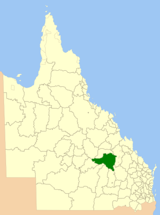
Albinia is a locality in the Central Highlands Region, Queensland, Australia. [2] In the 2016 census, Albinia had a population of 112 people. [1]

Suburbs and localities are the names of geographic subdivisions in Australia, used mainly for address purposes. The term locality is used in rural areas, while the term suburb is used in urban areas. Australian postcodes closely align with the boundaries of localities and suburbs.

Central Highlands Region Local government area in Queensland, Australia

Central Highlands Region is a local government area in Queensland, Australia.

Queensland North-east state of Australia

Queensland is the second-largest and third-most populous state in the Commonwealth of Australia. Situated in the north-east of the country, it is bordered by the Northern Territory, South Australia and New South Wales to the west, south-west and south respectively. To the east, Queensland is bordered by the Coral Sea and Pacific Ocean. To its north is the Torres Strait, with Papua New Guinea located less than 200 km across it from the mainland. The state is the world's sixth-largest sub-national entity, with an area of 1,852,642 square kilometres (715,309 sq mi).

Contents

Geography

The western part of the locality is mountainous with individual peaks such as Mount Hope at 596 metres (1,955 ft) and Mount Kelman at 470 metres (1,540 ft). [3] [4] The eastern part of the locality falls toward the east to elevations of 200 metres (660 ft). [5] The Mount Hope State Forest is in the western part of the locality including the mountain itself.

A number of creeks flow from west to east across the locality including Albinia Creek. These creeks are tributaries of the Comet River and ultimately contribute to the Fitzroy River which flows into the Coral Sea. [5] [6]

Comet River river in Australia

The Comet River is a river located in Central Queensland, Australia.

Fitzroy River (Queensland) river in Queensland, Australia

The Fitzroy River is a river located in Central Queensland, Australia. Its catchment covers an area of 142,665 square kilometres (55,083 sq mi), making it the largest river catchment flowing to the eastern coast of Australia.

Coral Sea A marginal sea of the South Pacific off the northeast coast of Australia

The Coral Sea is a marginal sea of the South Pacific off the northeast coast of Australia, and classified as an interim Australian bioregion. The Coral Sea extends 2,000 kilometres (1,200 mi) down the Australian northeast coast.

The large Rolleston coal mine is operated by Glencore Coal in the centre of the locality. The mine is supported by a number of dams and other infrastructure. A branch of the Blackwater railway system provides transport for the coal. [5]

Glencore plc is a British–Swiss multinational commodity trading and mining company with headquarters in Baar, Switzerland, and its registered office in Saint Helier, Jersey. The current company was created through a merger of Glencore with Xstrata on 2 May 2013. As of 2015, it ranked tenth in the Fortune Global 500 list of the world's largest companies.

Blackwater railway system

The Blackwater railway system is located in Central Queensland and services the coal mining area of the Bowen Basin. It carries coal, as well as products, to other destinations by way of connections to the North Coast Line at Rocklands and the Goonyella Line via Gregory coal mine to Oaky Creek. Together with the Moura line the two railway systems are known as the Capricornia Coal Chain.

To the east of the mine is the Albinia National Park. [7]

The Dawson Highway passes through from east to north.

Dawson Highway highway in Queensland

The Dawson Highway is a state highway in Queensland, Australia. It runs for 405 km between Gladstone and Springsure where it terminates. From Gladstone to Rolleston it is signed as State Route 60, and then A7 onwards to Springsure. It continues west for another 247 km as Dawson Developmental Road to Tambo on the Landsborough Highway. North of Springsure, A7 becomes the Gregory Highway.
History

The locality and creek are believed to derive their names from the Albinia Downs, which was named by Ludwig Leichhardt on 28 December 1844 during his overland journey from Moreton Bay to Port Essington in the Northern Territory. [6]

Related Research Articles

Tieri Town in Queensland, Australia

Tieri is a small mining town and locality in the Central Highlands Region, Queensland, Australia. Established in 1983, the town like nearby Middlemount and Dysart, is a service centre for local coal mines. In the 2016 census, Tieri had a population of 1,129 people.

Mackenzie River, Queensland Suburb of Isaac Region, Queensland, Australia

Mackenzie River is a locality in the Isaac Region, Queensland, Australia. In the 2016 census, Mackenzie River had a population of 71 people.

Mount Whitestone, Queensland Suburb of Lockyer Valley Region, Queensland, Australia

Mount Whitestone is a locality in the Lockyer Valley Region, Queensland, Australia. In the 2016 census, Mount Whitestone had a population of 154 people.

Argyll, Queensland Suburb of Central Highlands Region, Queensland, Australia

Argyll is a rural locality in the Central Highlands Region, Queensland, Australia. In the 2016 census, Argyll had a population of 31 people, but its boundaries have subsequently changed.

Strathfield, Queensland Suburb of Isaac Region, Queensland, Australia

Strathfield is a locality in the Isaac Region, Queensland, Australia.

Mount Ossa, Queensland Town in Queensland, Australia

Mount Ossa is a town and a coastal locality in the Mackay Region, Queensland, Australia.

Nandowrie, Queensland Suburb of Central Highlands Region, Queensland, Australia

Nandowrie is a locality in the Central Highlands Region, Queensland, Australia. In the 2016 census, Nandowrie had a population of 45 people.

Alsace, Queensland Suburb of Central Highlands Region, Queensland, Australia

Alsace is a rural locality in the Central Highlands Region, Queensland, Australia. In the 2016 census, Alsace had a population of 3 people.

Mount Debateable, Queensland Suburb of North Burnett Region, Queensland, Australia

Mount Debateable is a rural locality in the North Burnett Region, Queensland, Australia. In the 2016 census, Mount Debateable had a population of 54 people.

Porcupine, Queensland Suburb of Shire of Flinders, Queensland, Australia

Porcupine is a locality in the Shire of Finders, Queensland, Australia. In the 2016 census, Porcupine had a population of 49 people.

Mackenzie, Queensland (Central Highlands) Suburb of Central Highlands Region, Queensland, Australia

Mackenzie is a locality in the Central Highlands Region, Queensland, Australia. In the 2016 census, Mackenzie had a population of 37 people.

Eungella Dam, Queensland Suburb of Mackay Region, Queensland, Australia

Eungella Dam is a locality in the Mackay Region, Queensland, Australia. In the 2016 census, Eungella Dam had a population of 12 people.

Leslie Dam, Queensland Suburb of Southern Downs Region, Queensland, Australia

Leslie Dam is a locality in the Southern Downs Region, Queensland, Australia. In the 2016 census, Leslie Dam had a population of 163 people.

Mount Mackay, Queensland Suburb of Cassowary Coast Region, Queensland, Australia

Mount Mackay is a locality in the Cassowary Coast Region, Queensland, Australia. In the 2016 census, Mount Mackay had a population of 0 people.

Cona Creek, Queensland Suburb of Central Highlands Region, Queensland, Australia

Cona Creek is a locality in the Central Highlands Region, Queensland, Australia. In the 2016 census, Cona Creek had a population of 83 people.

Boulder Creek, Queensland Suburb of Rockhampton Region, Queensland, Australia

Boulder Creek is a locality in the Rockhampton Region, Queensland, Australia. In the 2016 census, Boulder Creek had a population of 12 people.

Dirnbir, Queensland Suburb of North Burnett Region, Queensland, Australia

Dirnbir is a rural locality in the North Burnett Region, Queensland, Australia. In the 2016 census, Dirnbir had a population of 49 people.

Woowoonga, Queensland Suburb of North Burnett Region, Queensland, Australia

Woowoonga is a locality in the North Burnett Region, Queensland, Australia. In the 2016 census, Woowoonga had a population of 92 people.

Biarra, Queensland Suburb of Somerset Region, Queensland, Australia

Biarra is a rural locality in the Somerset Region, Queensland, Australia. In the 2016 census, Biarra had a population of 257 people.

Peak Vale, Queensland Suburb of Isaac Region, Queensland, Australia

Peak Vale is a rural locality split between the Isaac Region and the Central Highlands Region, Queensland, Australia. In the 2016 census, Peak Vale had a population of 39 people.

References

  1. 1 2 Australian Bureau of Statistics (27 June 2017). "Albinia (SSC)". 2016 Census QuickStats. Retrieved 20 October 2018. OOjs UI icon edit-ltr-progressive.svg
  2. "Albinia - locality in Central Highlands Region (entry 46907)". Queensland Place Names. Queensland Government . Retrieved 23 April 2019.
  3. "Mount Hope - mountain in the Central Highlands Region (entry 16121)". Queensland Place Names. Queensland Government . Retrieved 23 April 2019.
  4. "Mount Kelman - mountain in the Central Highlands Region (entry 17894)". Queensland Place Names. Queensland Government . Retrieved 23 April 2019.
  5. 1 2 3 "Queensland Globe". State of Queensland . Retrieved 22 April 2019.
  6. 1 2 "Albinia Creek - watercourse in the Central Highlands Region (entry 234)". Queensland Place Names. Queensland Government . Retrieved 23 April 2019.
  7. "Albinia National Park - state forest in Central Highlands Region (entry 49137)". Queensland Place Names. Queensland Government . Retrieved 23 April 2019.