Alsace, Queensland

Last updated

Alsace
Queensland
Australia Queensland location map.svg
Red pog.svg
Alsace
Coordinates 23°17′21″S149°16′29″E / 23.2891°S 149.2747°E / -23.2891; 149.2747 Coordinates: 23°17′21″S149°16′29″E / 23.2891°S 149.2747°E / -23.2891; 149.2747
Population3 (2016 census) [1]
 • Density0.0086/km2 (0.022/sq mi)
Postcode(s) 4702
Area350.7 km2 (135.4 sq mi)
LGA(s) Central Highlands Region
State electorate(s) Gregory
Federal Division(s) Flynn
Suburbs around Alsace:
Bingegang Mackenzie Mackenzie
Jellinbah Alsace Mackenzie
Jellinbah Dingo Dingo

Alsace is a rural locality in the Central Highlands Region, Queensland, Australia. [2] In the 2016 census, Alsace had a population of 3 people. [1]

Suburbs and localities are the names of geographic subdivisions in Australia, used mainly for address purposes. The term locality is used in rural areas, while the term suburb is used in urban areas. Australian postcodes closely align with the boundaries of localities and suburbs.
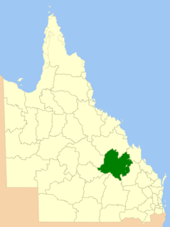
Central Highlands Region Local government area in Queensland, Australia

Central Highlands Region is a local government area in Queensland, Australia.

Queensland North-east state of Australia

Queensland is the second-largest and third-most populous state in the Commonwealth of Australia. Situated in the north-east of the country, it is bordered by the Northern Territory, South Australia and New South Wales to the west, south-west and south respectively. To the east, Queensland is bordered by the Coral Sea and Pacific Ocean. To its north is the Torres Strait, with Papua New Guinea located less than 200 km across it from the mainland. The state is the world's sixth-largest sub-national entity, with an area of 1,852,642 square kilometres (715,309 sq mi).

Contents

Geography

The land is at an elevation of approximately 150 metres (490 ft) and is principally used for grazing. A number of creek flow through the locality towards its south-east where in neighbouring Dingo, they become tributaries of Lorraine Creek, which flows into the Mackenzie River and then the Fitzroy River, which enters the Coral Sea to the south of Rockhampton. [3]

Pastoralism branch of agriculture concerned with raising livestock

Pastoralism is a form of animal husbandry, historically by nomadic people who moved with their herds. The species involved included cattle, camels, goats, yaks, llamas, reindeer, horses and sheep.

Dingo, Queensland Town in Queensland, Australia

Dingo is a town and locality in the Central Highlands Region in Queensland, Australia. In the 2011 census, Dingo had a population of 342 people.

Mackenzie River (Queensland) tributary of the Fitzroy River in Queensland, Australia

The Mackenzie River is a river located in Central Queensland, Australia. The Mackenzie River is a major tributary of the Fitzroy River, part of the largest river catchment flowing to the eastern coast of Australia.

The Fitzroy Developmental Road forms the western boundary of the locality which has no internal roads. [3]

Fitzroy Developmental Road

The Fitzroy Developmental Road is a designated road in the Central Highlands Region of Queensland consisting of three separate segments. The general direction is from south to north.

History

The locality is named after a pastoral property on the Leichhardt River. In the early 1870s, F.A. Brodie named two adjoining properties Alsace and Lorraine after the two regions Alsace and Lorraine in France that were lost to Germany in the Franco-Prussian War. [4]

Leichhardt River river in Australia

The Leichhardt River is a river in north west Queensland, Australia.

Alsace Place in Grand Est, France

Alsace is a cultural and historical region in eastern France, on the west bank of the upper Rhine next to Germany and Switzerland.

Lorraine Place in Grand Est, France

Lorraine is a cultural and historical region in north-eastern France, now located in the administrative region of Grand Est. Lorraine's name stems from the medieval kingdom of Lotharingia, which in turn was named for either Emperor Lothair I or King Lothair II. It later was ruled as the Duchy of Lorraine before the Kingdom of France annexed it in 1766.

Alsace State School opened on 9 Aug 1977 and closed on 11 December 1987. [5]

Education

There are no schools in Alsace. The nearest primary school is in neighbouring Dingo to the south (over 1 hour's drive away). The nearest secondary schools are in Blackwater and Middlemount, even further away. [3] Distance education.would be another option.

Blackwater, Queensland Town in Queensland, Australia

Blackwater is both a town and a locality in the Central Highlands Region, Queensland, Australia, 190 km west of Rockhampton. It is a town in a significant coal mining area in Central Queensland. The name of the township was inspired by the dark colour of local waterholes.

Middlemount, Queensland Town in Queensland, Australia

Middlemount is a town and locality in Isaac Region, Central Queensland, Australia. At the 2011 census, Middlemount had a population of 1,914. It is nicknamed the "Giant Peanut" by some locals due to its peanut-shaped road layout.

Distance education or long-distance learning is the education of students who may not always be physically present at a school. Traditionally, this usually involved correspondence courses wherein the student corresponded with the school via post. Today it involves online education. A distance learning program can be completely distance learning, or a combination of distance learning and traditional classroom instruction. Massive open online courses (MOOCs), offering large-scale interactive participation and open access through the World Wide Web or other network technologies, are recent developments in distance education. A number of other terms are used roughly synonymously with distance education.

Related Research Articles

Mackenzie River, Queensland Suburb of Isaac Region, Queensland, Australia

Mackenzie River is a locality in the Isaac Region, Queensland, Australia. In the 2016 census, Mackenzie River had a population of 71 people.

Hodgson Vale, Queensland Suburb of Toowoomba, Queensland, Australia

Hodgson Vale is a rural locality in the Toowoomba Region, Queensland, Australia. In the 2016 census, Hodgson Vale had a population of 1,379 people.

Minnamoolka, Queensland Suburb of Tablelands Region, Queensland, Australia

Minnamoolka is a locality in the Tablelands Region, Queensland, Australia. In the 2016 census, Minnamoolka had a population of 38 people.

Cornish Creek, Queensland Suburb of Barcaldine Region, Queensland, Australia

Cornish Creek is a locality in the Barcaldine Region, Queensland, Australia. In the 2016 census, Cornish Creek had a population of 16 people.

Rhydding, Queensland Suburb of Central Highlands Region, Queensland, Australia

Rhydding is a locality in the Central Highlands Region, Queensland, Australia.

Albinia, Queensland Suburb of Central Highlands Region, Queensland, Australia

Albinia is a locality in the Central Highlands Region, Queensland, Australia. In the 2016 census, Albinia had a population of 112 people.

Balberra, Queensland Suburb of Mackay Region, Queensland, Australia

Balberra is a coastal locality in the Mackay Region, Queensland, Australia. In the 2016 census, Balberra had a population of 457 people.

Duingal, Queensland Suburb of Bundaberg Region, Queensland, Australia

Duingal is a locality in the Bundaberg Region, Queensland, Australia. In the 2016 census, Duingal had a population of 77 people.

Cona Creek, Queensland Suburb of Central Highlands Region, Queensland, Australia

Cona Creek is a locality in the Central Highlands Region, Queensland, Australia. In the 2016 census, Cona Creek had a population of 83 people.

Old Cooranga, Queensland Suburb of North Burnett Region, Queensland, Australia

Old Cooranga is a rural locality in the North Burnett Region, Queensland, Australia. In the 2016 census, Old Cooranga had a population of 27 people.

Dirnbir, Queensland Suburb of North Burnett Region, Queensland, Australia

Dirnbir is a rural locality in the North Burnett Region, Queensland, Australia. In the 2016 census, Dirnbir had a population of 49 people.

Woowoonga, Queensland Suburb of North Burnett Region, Queensland, Australia

Woowoonga is a locality in the North Burnett Region, Queensland, Australia. In the 2016 census, Woowoonga had a population of 92 people.

Ingberry, Queensland Suburb of Barcaldine Region, Queensland, Australia

Ingberry is a locality in the Barcaldine Region, Queensland, Australia. In the 2016 census, Ingberry had a population of 11 people.

Ibis, Queensland Suburb of Barcaldine Region, Queensland, Australia

Ibis is a locality in the Barcaldine Region, Queensland, Australia. In the 2016 census, Ibis had a population of 4 people.

Pelican Creek, Queensland Suburb of Barcaldine Region, Queensland, Australia

Pelican Creek is a locality in the Barcaldine Region, Queensland, Australia. In the 2016 census, Pelican Creek had a population of 20 people.

Sardine, Queensland Suburb of Barcaldine Region, Queensland, Australia

Sardine is a locality in the Barcaldine Region, Queensland, Australia. In the 2016 census, Sardine had a population of 5 people.

Drummondslope, Queensland Suburb of Barcaldine Region, Queensland, Australia

Drummondslope is a locality in the Barcaldine Region, Queensland, Australia. In the 2016 census, Drummondslope had a population of 43 people.

Dunrobin, Queensland Suburb of Barcaldine Region, Queensland, Australia

Dunrobin is a locality in the Barcaldine Region, Queensland, Australia. In the 2016 census, Dunrobin had a population of 14 people.

Surbiton, Queensland Suburb of Barcaldine Region, Queensland, Australia

Surbiton is a locality in the Barcaldine Region, Queensland, Australia. In the 2016 census, Surbiton had a population of 80 people.

References

  1. 1 2 Australian Bureau of Statistics (27 June 2017). "Alsace (SSC)". 2016 Census QuickStats. Retrieved 20 October 2018. OOjs UI icon edit-ltr-progressive.svg
  2. "Alsace - locality in Central Highlands Region (entry 46908)". Queensland Place Names. Queensland Government . Retrieved 23 April 2019.
  3. 1 2 3 "Queensland Globe". State of Queensland . Retrieved 23 April 2019.
  4. "NOMENCLATURE OF QUEENSLAND.—8 - (Compiled from records in the Oxley Memorial Library.) - The Courier-Mail (Brisbane, Qld. : 1933 - 1954) - 8 Oct 1935". Trove. Retrieved 24 April 2019.
  5. Queensland Family History Society (2010), Queensland schools past and present (Version 1.01 ed.), Queensland Family History Society, ISBN   978-1-921171-26-0