
The Gemfields is a locality in the Central Highlands Region, Queensland, Australia. In the 2016 census, The Gemfields had a population of 1,449 people.

Rubyvale is a rural town in the Central Highlands Region, Queensland, Australia. In the 2016 census, Rubyvale had a population of 640 people. It is one of three towns within the locality of The Gemfields.

Sapphire is a town in the Central Highlands Region, Queensland, Australia. Situated in a locality called The Gemfields, sapphires are mined extensively in the area. At the 2016 census, Sapphire had a population of 572 people.
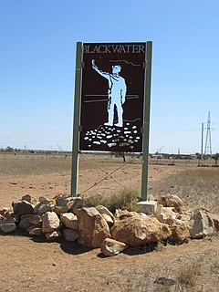
Blackwater is both a town and a locality in the Central Highlands Region, Queensland, Australia, 190 km west of Rockhampton. It is a town in a significant coal mining area in Central Queensland. The name of the township was inspired by the dark colour of local waterholes.

Yeppoon is a coastal town and locality in the Shire of Livingstone, Queensland, Australia. Yeppoon is renowned for its beaches, tropical climate, and the islands out on the bay. Twenty-five minutes from the city of Rockhampton, Yeppoon is the principal town on the Capricorn Coast, a string of seaside communities stretching more than 150 kilometres (93 mi) from north to south. The beaches and shallow coves provide a destination both for tourists and retirees settling down in Central Queensland. Offshore, there are 27 islands including Great Keppel Island which is 20 kilometres (12 mi) from Yeppoon.
Emerald is a rural town and locality in the Central Highlands Region, Queensland, Australia. As at June 2018, Emerald had an urban population of 14,119. The town is the business centre for the Central Highlands Regional Council.
Bogantungan is a rural town in the locality of Willows in the Central Highlands Region, Queensland, Australia.

The Capricorn Highway is located in Central Queensland, Australia, and links the city of Rockhampton with western Queensland. The highway is 575 kilometres long, and joins the Landsborough Highway at Barcaldine. Formerly National Route 66, Queensland began to convert to the alphanumeric system much of Australia had adopted in the early-2000s and is now designated as A4. The highway runs parallel with the Tropic of Capricorn, hence its name.

Central Queensland is an ambiguous geographical division of Queensland that centres on the eastern coast, around the Tropic of Capricorn. Its major regional centre is Rockhampton. The region extends from the Capricorn Coast west to the Central Highlands at Emerald, north to the Mackay Regional Council southern boundary, and south to Gladstone. The region is also known as Capricornia. It is one of Australia's main coal exporting regions.
Westwood is a town in the Rockhampton Region and a locality split between the Rockhampton Region and the Shire of Banana in Queensland, Australia. It was the first town gazetted by the Queensland Government. In the 2016 census, Westwood had a population of 174 people.

Capella is a small town and locality in the Central Highlands Region, Queensland, Australia. In the 2016 census, Capella had a population of 1,010 people.
Bluff is a rural town and locality in the Central Highlands Region, Queensland, Australia. In the 2016 census, Bluff had a population of 373 people.
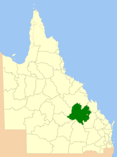
Central Highlands Region is a local government area in Queensland, Australia.
Comet is a historical rich rural town and locality in the Central Highlands Region, Queensland, Australia. In the 2016 census, Comet had a population of 498 people. Explore Comet's history along the Comet Tails and Walking Trails.
Marist College Emerald is a Catholic, co-educational day school located in Emerald, a rural town located in the Central Highlands, about 3 hours west of Rockhampton, Queensland, Australia.

Dingo is a town and locality in the Central Highlands Region in Queensland, Australia.
Lochington is a locality in the Central Highlands Region, Queensland, Australia.
The Capricorn Way is an Australian road route from Rockhampton to Barcaldine in Queensland. Using the Capricorn Way, it is 579.67 km (360.19 mi) from Rockhampton to Barcaldine. The recommended journey time, allowing for some sightseeing, food and rest is 30 hours. It has been designated by the Queensland Government as a State Strategic Touring Route.
Willows is a rural locality in the Central Highlands Region, Queensland, Australia. In the 2016 census, Willows had a population of 144 people.
Fairy Bower is a suburb of Rockhampton in the Rockhampton Region, Queensland, Australia.


