Fork Lagoons, Queensland

Last updated

Map all coordinates using: OpenStreetMap  
Download coordinates as: KML
Fork Lagoons
Queensland
Australia Queensland location map.svg
Red pog.svg
Fork Lagoons
Coordinates 23°20′42″S147°57′18″E / 23.3450°S 147.9550°E / -23.3450; 147.9550 (Fork Lagoons (centre of locality)) Coordinates: 23°20′42″S147°57′18″E / 23.3450°S 147.9550°E / -23.3450; 147.9550 (Fork Lagoons (centre of locality))
Population33 (2021 census) [1]
 • Density0.0565/km2 (0.1465/sq mi)
Postcode(s) 4723
Area583.6 km2 (225.3 sq mi)
Time zone AEST (UTC+10:00)
LGA(s) Central Highlands Region
State electorate(s) Gregory
Federal division(s) Flynn
Suburbs around Fork Lagoons:
Carbine Creek Hibernia Gordonstone
Argyll Fork Lagoons Wyuna
Rubyvale
Sapphire Central
Anakie Siding Emerald

Fork Lagoons is a rural locality in the Central Highlands Region, Queensland, Australia. [2] At the 2021 census, Fork Lagoons had a population of 33 people. [1]

Contents

The postcode of Fork Lagoons is 4723. [3]

Geography

Fork Lagoons is bounded to the north and east by Theresa Creek and Retreat Creek to the south. [4]

Kingower Billabong is a billabong in the east of the locality ( 23°24′00″S148°04′00″E / 23.4°S 148.0666°E / -23.4; 148.0666 (Kingower Billabong) ). [5]

There are a number of state forests within the locality: Crystal Creek State Forest, Kettle State Forest and Burn State Forest. Apart from these, the land use is predominantly grazing on native vegetation with a small area of crop growing in the south-east of the locality. [4]

History

The locality was officially named and bounded on 16 June 2000. [2]

In the 2016 census, Fork Lagoons had a population of 0 people. [6]

Education

There are no schools in Fork Lagoons. The nearest primary schools are Anakie State School in neighbouring Anakie Siding to the south-west, Capella State School in Capella to the north, and Denison State School and Emerald North State School, both in neighbouring Emerald to the south-west. The nearest secondary schools are Capella State High School in Capella and Emerald State High School in Emerald. [4]

Related Research Articles

<span class="mw-page-title-main">The Gemfields</span> Suburb of Central Highlands Region, Queensland, Australia

The Gemfields is a former locality in the Central Highlands Region, Queensland, Australia. In the 2016 census, The Gemfields had a population of 1,449 people.

<span class="mw-page-title-main">Rubyvale, Queensland</span> Suburb of Central Highlands Region, Queensland, Australia

Rubyvale is a rural town and locality in the Central Highlands Region, Queensland, Australia. In the 2016 census, the town of Rubyvale had a population of 640 people.

Willows Gemfields is a rural town in the locality of Willows in the Central Highlands Region, Queensland, Australia. In the 2016 census, Willows Gemfields had a population of 114 people.

Sapphire Central is a rural locality in the Central Highlands Region, Queensland, Australia. The town of Sapphire is within the locality. Sapphires are mined extensively in the area. At the 2021 census, the locality had a population of 1214 people.

<span class="mw-page-title-main">Emerald, Queensland</span> Town in Queensland, Australia

Emerald is a rural town and locality in the Central Highlands Region, Queensland, Australia. In the 2021 census, Emerald had a population of 14,906 people.

<span class="mw-page-title-main">Anakie Siding, Queensland</span> Small town in central Queensland, Australia

Anakie Siding is a rural locality in the Central Highlands Region, Queensland, Australia. The town of Anakie is within the locality. It is a sapphire mining area.

<span class="mw-page-title-main">Capella, Queensland</span> Town in Queensland, Australia

Capella is a rural town and locality in the Central Highlands Region, Queensland, Australia. At the 2021 census the locality of Capella had a population of 974 people.

Mackenzie River is a locality in the Isaac Region, Queensland, Australia. In the 2016 census, Mackenzie River had a population of 71 people.

<span class="mw-page-title-main">Central Highlands Region</span> Local government area in Queensland, Australia

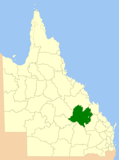
Central Highlands Region is a local government area in Queensland, Australia.

<span class="mw-page-title-main">Gindie</span> Suburb of Central Highlands Region, Queensland, Australia

Gindie is a rural locality in the Central Highlands Region, Queensland, Australia. At the 2021 census, Gindie had a population of 232 people.

Lochington is a rural locality in the Central Highlands Region, Queensland, Australia. At the 2021 census, Lochington had a population of 128 people.

Crinum is a rural locality in the Central Highlands Region, Queensland, Australia. At the 2021 census, Crinum had a population of 86 people.

<span class="mw-page-title-main">Argyll, Queensland</span> Suburb of Central Highlands Region, Queensland, Australia

Argyll is a rural locality in the Central Highlands Region, Queensland, Australia. At the 2021 census, Argyll had a population of 25 people,

Hampden is a rural locality in the Mackay Region, Queensland, Australia. In the 2016 census, Hampden had a population of 566 people.

<span class="mw-page-title-main">Willows, Queensland</span> Suburb of Central Highlands Region, Queensland, Australia

Willows is a rural locality in the Central Highlands Region, Queensland, Australia. In the 2016 census, Willows had a population of 144 people.

Eurella is a rural locality in the Maranoa Region, Queensland, Australia. In the 2016 census, Eurella had a population of 11 people.

Cona Creek is a locality in the Central Highlands Region, Queensland, Australia. At the 2021 census, Cona Creek had a population of 57 people.

Hibernia is a rural locality in the Central Highlands Region, Queensland, Australia. At the 2021 census, Hibernia had a population of 82 people.

Gordonstone is a rural locality in the Central Highlands Region, Queensland, Australia. At the 2021 census, Gordonstone had a population of 32 people.

Kilmorey Falls is a rural locality in the Maranoa Region, Queensland, Australia. In the 2016 census Kilmorey Falls had a population of 0 people.

References

  1. 1 2 "2021 Fork Lagoons, Census All persons QuickStats | Australian Bureau of Statistics". www.abs.gov.au. Retrieved 28 June 2022.
  2. 1 2 "Fork Lagoons – locality in Central Highlands Region (entry 46950)". Queensland Place Names. Queensland Government . Retrieved 25 October 2019.
  3. "Fork Lagoons Postcode". Australia Post . Retrieved 13 November 2020.
  4. 1 2 3 "Queensland Globe". State of Queensland . Retrieved 29 October 2020.
  5. "Kingower Billabong – lake in Central Highlands Regional (entry 18222)". Queensland Place Names. Queensland Government . Retrieved 7 July 2020.
  6. Australian Bureau of Statistics (27 June 2017). "Fork Lagoons (SSC)". 2016 Census QuickStats. Retrieved 20 October 2018. OOjs UI icon edit-ltr-progressive.svg