Arcadia Valley, Queensland

Last updated

Arcadia Valley
Queensland
Australia Queensland location map.svg
Red pog.svg
Arcadia Valley
Coordinates 25°00′55″S148°47′44″E / 25.0152°S 148.7955°E / -25.0152; 148.7955 Coordinates: 25°00′55″S148°47′44″E / 25.0152°S 148.7955°E / -25.0152; 148.7955
Population102 (2016 census) [1]
 • Density0.04816/km2 (0.1247/sq mi)
Postcode(s) 4454
Area2,117.8 km2 (817.7 sq mi)
Time zone AEST (UTC+10:00)
LGA(s) Central Highlands Region
State electorate(s) Gregory
Federal Division(s) Flynn
Suburbs around Arcadia Valley:
Consuelo Coorumbene
Humboldt
Dromedary
Rewan
Carnarvon Park
Arcadia Valley Mungabunda
Glenhaughton
Upper Dawson Beilba Baroondah

Arcadia Valley is a rural locality in the Central Highlands Region, Queensland, Australia. [2] In the 2016 census, Arcadia Valley had a population of 102 people. [1]

Contents

History

It is believed that squatters in the 1850s named the area Arcadia meaning quiet rural simplicity . [2]

Arcadia Valley State School opened on 3 March 1975. [3] [4]

Arcadia Valley was within the Shire of Bauhinia until 2008, when that shire was amalgamated into the Central Highlands Region.

In the 2011 census, the population of Arcadia Valley was too low to be separately reported and was included within neighbouring Rewan, which had a reported population of 465 people. [5]

Economy

The tradition mainstay of the local economy is beef production with cattle farms being the predominant land use. However, from 2013 Santos have been purchasing land and planning infrastructure for liquid natural gas extraction in the area with a pipeline to Gladstone. [6] [7]

Education

Arcadia Valley State School is a government co-educational primary (P-7) school at 4831 Arcadia Valley Road. In 2013 the school had five students and two teachers (one full-time equivalent). The children come from local farms. The school does not have access to reticulated water and must depend on tanks filled by rainwater. [8]

Attractions

Lake Nuga Nuga is within the locality. Part of the Nuga Nuga National Park, it is the largest natural lake in the Central Queensland sandstone belt and is popular for bird-watching (over 150 kinds of birds), fishing and canoeing. [9]

Related Research Articles

Banana, Queensland Town in Queensland, Australia

Banana is a small town and rural locality in the Shire of Banana, Central Queensland, Australia.

Rolleston, Queensland Town in Queensland, Australia

Rolleston is a small town and locality in the Central Highlands Region, Queensland, Australia.

Yelarbon Town in Queensland, Australia

Yelarbon is a rural town and locality in the Goondiwindi Region, Queensland, Australia. It is on the border of Queensland and New South Wales. In the 2016 census, Yelarbon had a population of 364 people.

Springsure Town in Queensland, Australia

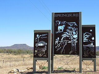
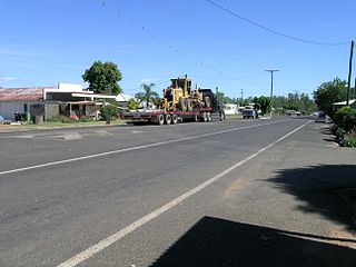
Springsure is a town and a locality in the Central Highlands Region, Queensland, Australia. It is 66 kilometres (41 mi) south of Emerald on the Gregory Highway. It is the southern terminus of the Gregory Highway and the northern terminus of the Dawson Highway. It is 765 kilometres (475 mi) northwest of Brisbane. In the 2016 census, Springsure had a population of 1,103 people.

Capella, Queensland Town in Queensland, Australia

Capella is a small town and locality in the Central Highlands Region, Queensland, Australia. In the 2016 census, Capella had a population of 1,010 people.

Eidsvold, Queensland Town in Queensland, Australia

Eidsvold is a rural town and locality in the North Burnett Region, Queensland, Australia. The town is the self-proclaimed Beef Capital of the Burnett and is a hub for the regional cattle industry. In the 2016 census, Eidsvold had a population of 574 people.

Baralaba, Queensland Town in Queensland, Australia

Baralaba is a rural town and locality in the Shire of Banana in central Queensland, Australia. In the 2016 census, Baralaba had a population of 314 people.

Tieri Town in Queensland, Australia

Tieri is a small mining town and locality in the Central Highlands Region, Queensland, Australia. Established in 1983, the town like nearby Middlemount and Dysart, is a service centre for local coal mines. In the 2016 census, Tieri had a population of 1,129 people.

Shire of Bauhinia Local government area in Queensland, Australia

The Shire of Bauhinia was a local government area in Central Queensland, Queensland, Australia. The Shire, administered from the town of Springsure, covered an area of 23,649.6 square kilometres (9,131.2 sq mi), and existed as a local government entity from 1879 until 2008, when it was amalgamated with the Shires of Duaringa, Emerald and Peak Downs to form the Central Highlands Region.

Boyne Valley, Queensland Suburb of Gladstone Region, Queensland, Australia

The Boyne Valley is a rural locality in Gladstone Region, Queensland, Australia. The locality contains four small towns: Nagoorin, Ubobo, Builyan, and Many Peaks. In the 2016 census, Boyne Valley had a population of 358 people.

Thangool Town in Queensland, Australia

Thangool is a rural town and locality in the Shire of Banana, Queensland, Australia. In the 2016 census, Thangool had a population of 741 people.

Comet, Queensland Town in Queensland, Australia

Comet is a historical rich rural town and locality in the Central Highlands Region, Queensland, Australia. In the 2016 census, Comet had a population of 498 people. Explore Comet's history along the Comet Tails and Walking Trails.

Jambin, Queensland Town in Queensland, Australia

Jambin is a town and locality in the Shire of Banana, Queensland, Australia.

Byfield, Queensland Town in Queensland, Australia

Byfield is a locality in Shire of Livingstone, Queensland, Australia. Byfield is a rural locality in the Livingstone Shire, Queensland, Australia. In the 2016 census, Byfield had a population of 301 people.

Glenden, Queensland Town in Queensland, Australia

Glenden is a mining town and rural locality in the Isaac Region, Queensland, Australia.

Gindie Suburb of Central Highlands Region, Queensland, Australia

Gindie is a rural locality in the Central Highlands Region, Queensland, Australia. In the 2016 census, Gindie had a population of 209 people.

Lochington, Queensland Suburb of Central Highlands Region, Queensland, Australia

Lochington is a rural locality in the Central Highlands Region, Queensland, Australia. In the 2016 census, Lochington had a population of 57 people.

Carnarvon Park, Queensland Suburb of Central Highlands Region, Queensland, Australia

Carnarvon Park is a rural locality in the Central Highlands Region, Queensland, Australia. In the 2016 census, Carnarvon Park had a population of 3 people.

Rewan, Queensland Suburb of Central Highlands Region, Queensland, Australia

Rewan is a rural locality in the Central Highlands Region, Queensland, Australia. In the 2016 census, Rewan had a population of 22 people.

Hidden Valley, Queensland Suburb of Livingstone Shire, Queensland, Australia

Hidden Valley is a rural locality in the Livingstone Shire, Queensland, Australia. In the 2016 census, Hidden Valley had a population of 421 people.

References

  1. 1 2 Australian Bureau of Statistics (27 June 2017). "Arcadia Valley (SSC)". 2016 Census QuickStats. Retrieved 20 October 2018. OOjs UI icon edit-ltr-progressive.svg
  2. 1 2 "Arcadia Valley - locality in Central Highlands Region (entry 46909)". Queensland Place Names. Queensland Government . Retrieved 4 November 2019.
  3. "Opening and closing dates of Queensland Schools". Queensland Government . Retrieved 4 July 2014.
  4. "Agency ID 11083, Arcadia Valley State School". Queensland State Archives . Retrieved 5 July 2014.
  5. Australian Bureau of Statistics (31 October 2012). "Rewan (SSC)". 2011 Census QuickStats. Retrieved 5 July 2014. OOjs UI icon edit-ltr-progressive.svg
  6. Cranston, Matthew (18 November 2013). "Origin snares Qld cattle station". Queensland Country Life . Archived from the original on 14 July 2014. Retrieved 5 July 2014.
  7. Aurecon Australia Pty Ltd. "Arcadia Valley Ecological Assessment Report - Proposed Bottle Tree Dam" (PDF). Santos GLNG. Santos . Retrieved 5 July 2014.
  8. "2013 School Annual Report" (PDF). Arcadia Valley State School. Archived from the original (PDF) on 14 July 2014. Retrieved 4 July 2014.
  9. "About Nugu Nugu". Department of National Parks, Recreation, Sports and Racing, Queensland Government . Retrieved 4 July 2014.

Further reading