Hundred of Alma

Last updated

Alma
South Australia
Australia South Australia location map.svg
Red pog.svg
Alma
Coordinates 34°14′24″S138°38′49″E / 34.240°S 138.647°E / -34.240; 138.647 Coordinates: 34°14′24″S138°38′49″E / 34.240°S 138.647°E / -34.240; 138.647
Established22 May 1856
Area360 km2 (138 sq mi)
Region Northern Adelaide Plains
County Gawler
Lands administrative divisions around Alma:
Hall Upper Wakefield Saddleworth
Dalkey Alma Gilbert
Grace Mudla Wirra Light

The Hundred of Alma is a cadastral unit of hundred located on the northern Adelaide Plains of South Australia spanning the township of Alma and the Alma Plains. The hundred was proclaimed in 1856 in the County of Gawler and named by Governor Richard Graves MacDonnell for the River Alma on the Crimean Peninsula, the location of the Battle of the Alma, the first Allied victory in the Crimean War. [1] [2] The hundred is bounded on the north by the Wakefield River and on the south by the Light River

The Hundred of Alma includes all of the localities of Alma, Salter Springs, Woolshed Flat and parts of the localities of Hamley Bridge, Stockyard Creek, Undalya, Rhynie, Riverton, Giles Corner, Stockport. The largest town is now Hamley Bridge near the southern boundary. [3]

Plan of Hundred of Alma, 1929 Hundred of Alma, 1929 (22829186171).jpg
Plan of Hundred of Alma, 1929

Local government

The District Council of Rhynie was the first local government body established within the hundred. It was proclaimed in October 1865 and included approximately the northern half of the hundred. Its establishment was closely followed by that of the District Council of Stockport just a month later. Stockport council covered approximately the southern half of the hundred as well as small parts of the Hundred of Gilbert and Hundred of Light easterly adjacent. The council area lay either side of the Gilbert River from Giles Corner in the north to the Gilbert's confluence with the River Light at Hamley Bridge in the south. [4] [5]

Fifteen years on, in 1870, the District Council of Alma Plains was established by severing the western halves of Rhynie and Stockport councils. This meant that the hundred was roughly split in half, vertically, by the Gilbert River, with Alma Plains council administering the west and Rhynie and Stockport continuing to administer the east. [5]

In 1932 Alma Plains council was amalgamated with the westerly adjacent District Council of Dalkey to create the new District Council of Owen. In the same year the Stockport and Rhynie councils amalgamated with the District Council of Gilbert to their east to create the new District Council of Riverton. From this time local governance of the hundred was thus split between Owen in the west and Riverton in the east. [5]

In 1983, Owen council became a part of the District Council of Wakefield Plains. Then in 1997, Wakefield Plains council itself became a part of the much larger Wakefield Regional Council. On the same day in 1997, Riverton council became a part of the much larger District Council of Clare and Gilbert Valleys, leaving local governance of the hundred still split down the middle with Wakefield in the west and Clare and Gilbert Valleys in the east.

Related Research Articles

<span class="mw-page-title-main">Wakefield Regional Council</span> Local government area in South Australia

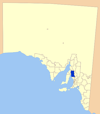
Wakefield Regional Council is a local government area in the Yorke and Mid North region of South Australia. The council seat is at Balaklava.

The District Council of Wakefield Plains was a local government area in South Australia from 1983 to 1997, seated at Balaklava.

<span class="mw-page-title-main">Riverton, South Australia</span> Town in South Australia

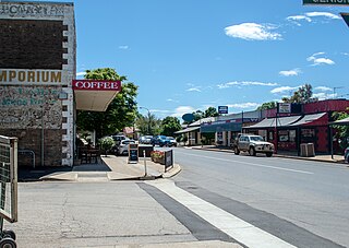
Riverton is a small town in the Mid North of South Australia, in the Gilbert Valley. It is situated on the Gilbert River, from which the town derives its name. Both the Gilbert Valley and Gilbert River were named after South Australian pioneer, Thomas Gilbert. Riverton was first settled in 1856, as a settlement along the bullock track from the mining town of Burra to the capital city Adelaide. It grew from a plan designed by a James Masters who had established the nearby town of Saddleworth. The streets of Riverton received their names chiefly from James Masters and his friends. They commemorate persons notable in the history of the district or the State. At the 2011 census, Riverton had a population of 810. Including the rural areas surrounding the town, the population was 1213.

<span class="mw-page-title-main">Clare and Gilbert Valleys Council</span> Local government area in South Australia

The Clare and Gilbert Valleys Council is a local government area located in the Yorke and Mid North region of South Australia. The council was founded on 1 July 1997 with the amalgamation of the District Council of Clare, the District Council of Riverton and the District Council of Saddleworth and Auburn. The council seat is located at Clare; it also maintains branch offices at Riverton and Saddleworth.

<span class="mw-page-title-main">Hamley Bridge, South Australia</span> Town in South Australia

Hamley Bridge is a community in South Australia located at the junction of the Gilbert and Light rivers, as well as the site of a former railway junction.

<span class="mw-page-title-main">Adelaide Plains Council</span> Local government area in South Australia

The Adelaide Plains Council is a local government area in South Australia. It consists of a largely rural region along the Gulf St Vincent, covering a total area of approximately 926 km2. The council seat lies at Mallala, but it also maintains a service centre at Two Wells.

Wooroora was an electoral district of the House of Assembly in the Australian colony of South Australia.

<span class="mw-page-title-main">Alma, South Australia</span> Town in South Australia

Alma is a small town in South Australia halfway between the Wakefield River, to the north, and River Light to the south. Alma, Alma South and Alma Plains were named for the cadastral Hundred of Alma in which they lie, which was in turn named after the Battle of the Alma, the site of an allied victory in the Crimean War.

The Hundred of Inkerman is a cadastral unit of hundred located on the northern Adelaide Plains in South Australia and bounded on the north by the Wakefield River. It is one of the eight hundreds of the County of Gawler. It was named in 1856 by Governor Richard MacDonnell after the Crimean War Battle of Inkerman.

<span class="mw-page-title-main">Hundred of Balaklava</span> Cadastral in South Australia

The Hundred of Balaklava is a cadastral unit of hundred located on the northern Adelaide Plains in South Australia immediately south of the Wakefield River. It is one of the eight hundreds of the County of Gawler. It was named in 1856 by Governor Dominick Daly after the Crimean War Battle of Balaklava. The township of Balaklava is at the extreme north east corner of the hundred.

<span class="mw-page-title-main">County of Light</span> Cadastral in South Australia

The County of Light is one of the 49 cadastral counties of South Australia. It was proclaimed by Governor George Grey in 1842 and named for the River Light, the river being named after Colonel William Light, the first Surveyor-General of South Australia. It covers the modern region of the Barossa Valley and a portion of the northern Mt Lofty Ranges. It is bounded by the upper Wakefield River in the north, the approximate path of Horrocks Highway in the west, and the North Para River in the south, and is bisected east to west by the River Light.

<span class="mw-page-title-main">Hundred of Dalkey</span> Cadastral in South Australia

The Hundred of Dalkey is a cadastral unit of hundred located on the northern Adelaide Plains in South Australia immediately south of the Wakefield River. It is one of the eight hundreds of the County of Gawler. It was named in 1856 by Governor Richard Graves MacDonnell for his hometown Dalkey, a seaside resort in Ireland.

<span class="mw-page-title-main">Hundred of Gilbert</span> Cadastral in South Australia

The Hundred of Gilbert is a cadastral unit of hundred in the northern Mount Lofty Ranges including the town of Riverton. It is one of the nine hundreds of the County of Light. It was proclaimed in 1851 by Governor Henry Young and named after the Gilbert River, which flows from north to south through the hundred. The river, in turn, was named in honour of South Australian pioneer Thomas Gilbert.

The District Council of Hall was a local government area in South Australia from 1878 to 1935.

The District Council of Blyth was a local government area in South Australia from 1872 to 1987 seated at Blyth in the Mid North.

<span class="mw-page-title-main">Hundred of Goyder</span> Cadastral in South Australia

The Hundred of Goyder is the cadastral unit of hundred on the northern Adelaide Plains centred on the locality of Goyder. It is one of the 16 hundreds of the County of Stanley. It was named in 1862 by Governor Dominick Daly after George Goyder, famed South Australian surveyor. In addition to the localities of Goyder and Beaufort, most of Nantawarra lies within the Hundred of Goyder. The portions of Port Wakefield and Bowmans north of the Wakefield River are also inside the hundred, and small parts of the localities of South Hummocks and Mount Templeton cross the western and eastern of boundaries of the hundred, respectively.

The District Council of Dalkey was a local government area seated at Owen in South Australia from 1875 to 1932.

The District Council of Stockport was a local government area in South Australia seated at Stockport from 1865 to 1932.

The District Council of Gilbert was a local government area seated at Riverton in South Australia from 1866 to 1932.

The District Council of Alma Plains was a local government area in South Australia seated at Alma from 1870 to 1932.

References

  1. "Placename Details: Hundred of Alma". Property Location Browser. Government of South Australia. 29 January 2009. SA0001003. Archived from the original on 7 December 2015. Retrieved 6 November 2017. Derivation of Name: A battle in the Crimean War; Other Details: Area 138 square miles. The Wakefield River forms the northern boundary of the Hundred.
  2. Manning, Geoffrey. "Alma" (PDF). Manning Index of South Austrlalian History - Place Names of South Australia. Retrieved 6 November 2017 via State Library of South Australia. The first surveys of the Hundred of Alma were made by James Elder in 1855 and it was proclaimed on 22 May 1856 during the vice-regal term of Sir Richard MacDonnell who, no doubt, dubbed it so because, on the banks of the River Alma in the Crimea, the allies gained their first victory in 1854; the name comes from a Tartar word meaning ‘apple tree’.
  3. "Hundreds, Suburbs and Localities". LocationSA Map Viewer. Retrieved 4 December 2020.
  4. "District of Stockport" (PDF). South Australian Government Gazette (50 ed.). Government of South Australia. 1865: 1069-1070. 23 November 1865. Retrieved 22 September 2017.
  5. 1 2 3 Marsden, Susan (2012). "A History of South Australian Councils to 1936" (PDF). Local Government Association of South Australia. Retrieved 6 November 2017.