
Snowtown is a town located in the Mid North of South Australia 145 km north of Adelaide and lies on the main road and rail routes between Adelaide and Perth – the Augusta Highway and Adelaide-Port Augusta railway line. The town's elevation is 103 metres and on average the town receives 389 mm of rainfall per annum.
The City of Prospect is an inner urban local government area (LGA) in Adelaide, South Australia. The council seat is the unusually-large suburb of Prospect, which makes up almost two thirds of the tiny council area, which is less than 8 km2 (3.1 sq mi). Established in 1872, it is one of the oldest local government bodies in South Australia.

Wasleys is a small town north-west of Gawler, South Australia. Roseworthy College is located around 6 km (3.7 mi) south of the town. At the 2016 census, Wasleys had a population of 348.

The Adelaide Plains Council is a local government area in South Australia. It consists of a largely rural region along the Gulf St Vincent, covering a total area of approximately 926 km2. The council seat lies at Mallala, but it also maintains a service centre at Two Wells.
The lands administrative divisions of South Australia are the cadastral units of counties and hundreds in South Australia. They are located only in the south-eastern part of the state, and do not cover the whole state. 49 counties have been proclaimed across the southern and southeastern areas of the state historically considered to be arable and thus in need of a cadastre. Within that area, a total of 540 hundreds have been proclaimed, although five were annulled in 1870, and, in some cases, the names reused elsewhere.

Marrabel is a township and locality beside the Light River in South Australia's Mid North. It is in the Clare and Gilbert Valleys Council local government area, 100 kilometres (62 mi) north west of the state capital, Adelaide. At the 2021 census, Marrabel had a population of 101.

The Light River, commonly called the River Light, is a seasonal and significant river in the Mid North region of the Australian state of South Australia named for early surveyor William Light.

The Hundred of Belvidere is a cadastral unit of hundred located in the north Barossa Valley of South Australia in the County of Light.
In South Australia, one of the states of Australia, there are many areas which are commonly known by regional names. Regions are areas that share similar characteristics. These characteristics may be natural such as the Murray River, the coastline, desert or mountains. Alternatively, the characteristics may be cultural, such as common land use. South Australia is divided by numerous sets of regional boundaries, based on different characteristics. In many cases boundaries defined by different agencies are coterminous.

Alma is a small town in South Australia halfway between the Wakefield River, to the north, and River Light to the south. Alma, Alma South and Alma Plains were named for the cadastral Hundred of Alma in which they lie, which was in turn named after the Battle of the Alma, the site of an allied victory in the Crimean War.
The Hundred of Port Gawler is a cadastral unit of hundred located on the central Adelaide Plains in South Australia and bounded on the south by the Gawler River. It is centred on the town of Two Wells with the locality of Port Gawler at the south western corner of its boundary. It is one of the eight hundreds of the County of Gawler. It was named in 1851 by Governor Henry Young either directly or indirectly after the former Governor George Gawler.

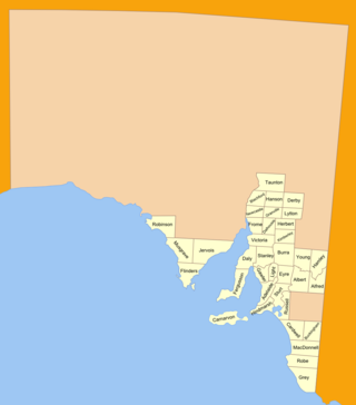
The County of Light is one of the 49 cadastral counties of South Australia. It was proclaimed by Governor George Grey in 1842 and named for the River Light, the river being named after Colonel William Light, the first Surveyor-General of South Australia. It covers the modern region of the Barossa Valley and a portion of the northern Mt Lofty Ranges. It is bounded by the upper Wakefield River in the north, the approximate path of Horrocks Highway in the west, and the North Para River in the south, and is bisected east to west by the River Light.
The District Council of East Torrens was a local government council of South Australia from 1853 to 1997.
Apoinga is a rural locality in the Mid North region of South Australia, situated in the Regional Council of Goyder.

The Hundred of Strathalbyn is a cadastral division of the County of Hindmarsh in South Australia. It lies west of the Adelaide Hills and east of Lake Alexandrina and includes at its southwestern extremity the town of Strathalbyn. Its name is derived from that used for a sub-division granted in 1841. No definitive derivation for the subdivision of Strathalbyn name is known but it is deemed probable that John Rankine or his brother William provided the name with the meaning given as "white valley" from the Scottish srath and albion. Mount Barker Creek forms much of the northern hundred boundary while the Bremer River forms the eastern border.
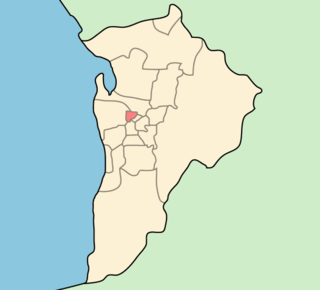
The Hundred of Gilbert is a cadastral unit of hundred in the northern Mount Lofty Ranges including the town of Riverton. It is one of the nine hundreds of the County of Light. It was proclaimed in 1851 by Governor Henry Young and named after the Gilbert River, which flows from north to south through the hundred. The river, in turn, was named in honour of South Australian pioneer Thomas Gilbert.
The District Council of Light was a local government area in South Australia from 1867 to 1892.
The Belvidere Range is a mountain range of the Northern Mount Lofty Ranges in South Australia.
The District Council of Kondoparinga was a local government area in South Australia from 1853 until 1935, at which point the council lands and resources formed the heart of the new District Council of Meadows.
The District Council of Kapunda was a local government area in South Australia from 1866 to 1996. The Kapunda town corporation was formed a year earlier in 1865 and ultimately amalgamated into the district council.

