
The Macquarie River or Wambuul is part of the Macquarie–Barwon catchment within the Murray–Darling basin, is one of the main inland rivers in New South Wales, Australia.

Snowtown is a town located in the Mid North of South Australia 145 km north of Adelaide and lies on the main road and rail routes between Adelaide and Perth – the Augusta Highway and Adelaide-Port Augusta railway line. The town's elevation is 103 metres and on average the town receives 389 mm of rainfall per annum.

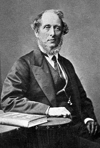
William Forster was a pastoral squatter, colonial British politician, Premier of New South Wales from 27 October 1859 to 9 March 1860, and poet.
Wheal Watkins mine, formerly Wheal Gawler mine, is an historic lead and silver mine in Glen Osmond, South Australia. The mine first operated from 1844 until 1850, and again briefly in 1888 to 1889, and 1916. From 1986 onwards, the mine was accessible by guided tour, until a rockfall event prompted its closure in 2005.
Johannes Menge, is regarded as South Australia's first geologist, though he had no formal qualifications. An early explorer of the new colony, he was influential in the settlement of the Barossa Valley.
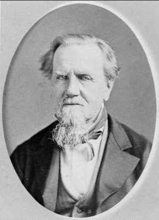
George Milner Stephen, often written G. Milner Stephen, was a South Australian and Victorian politician and faith healer.

Sandstone is a small town in the Mid West region of Western Australia 157 kilometres (98 mi) east of Mount Magnet and 661 kilometres (411 mi) north of the state capital, Perth. At the 2016 census, Sandstone and the surrounding Shire of Sandstone had a population of 89 people, including 19 families. Sandstone is the administrative centre and only town in the Shire of Sandstone local government area.
Glencoe is a town in South Australia, Australia, located 27 kilometres (17 mi) north-west of Mount Gambier.
George Hall, M.L.C., often styled "Captain Hall", was a South Australian shipping agent, company director and politician.
William Henville Burford was an apprenticed butcher with some experience as a tallow merchant and chandler in Cannon Street, St George's East, in the East End of London. In 1838 he emigrated to South Australia for his health's sake with his wife and three daughters on the Pestonjee Bomanjee, arriving at Glenelg on 11 October. Initially he found work as a painter and glazier, and soon had one of the larger businesses in the Colony. In 1840, when a recession had made those trades unprofitable, he was able to start a soap and candle factory, W. H. Burford & Sons, in 134 (154?) Grenfell Street. The business failed several times, but revived with the opening of the Burra copper mine in 1848, then the Moonta and Wallaroo mines around 1863.
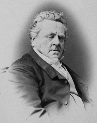
John Bentham Neales, frequently referred to as "J. Bentham Neales" or "Bentham Neales", was a businessman and politician in the early days of South Australia, by some regarded as the "Father of Mining in South Australia".
Maria was a brigantine of 136 tons, built in Dublin, Ireland, and launched in 1823 as a passenger ship.
James Crabb Verco was an early settler in the colony of South Australia, builder, businessman and parliamentarian. He was the father of Joseph Cooke Verco.

The Hundred of Belvidere is a cadastral unit of hundred located in the north Barossa Valley of South Australia in the County of Light.
Daniel Livingston was a carpenter, storekeeper and, briefly, politician in colonial South Australia.
Ned Kelly is a 1942 radio play by Douglas Stewart about the outlaw Ned Kelly.
Alfred Miller Mundy was an English military officer in colonial New South Wales, who after leaving the army served in the Legislative Council of South Australia, from 15 June 1843 to 14 May 1849.
H. L. Vosz was an Adelaide, South Australia business, for a time Australia's largest supplier of paints and glass, the earliest progenitor of Dulux paints, and became the prosperous glass merchant A. E. Clarkson Ltd. The company was founded in a modest way by a painter, plumber and glazier of more than usual business acumen, who unwittingly became the name behind many of the stained glass windows in South Australian churches and public buildings.
Angas Park is a region in South Australia, situated on the upper reaches of the Gawler River, and encompasses the towns of Nuriootpa, Angaston and Bethany.

The District Council of Belvidere was a local government area in South Australia. It was created to provide local government in the Hundred of Belvidere on 13 December 1866 and combined into the District Council of Kapunda on 12 May 1932.
