District Council of Yatala North

Last updated

District Council of Yatala North
South Australia
Australia South Australia location map.svg
Red pog.svg
District Council of Yatala North
Coordinates 34°46′S138°38′E / 34.767°S 138.633°E / -34.767; 138.633 Coordinates: 34°46′S138°38′E / 34.767°S 138.633°E / -34.767; 138.633
Established1868
Abolished1933
LGAs around District Council of Yatala North:
Munno Para West Munno Para West Munno Para East
Birkenhead
Port Adelaide
Rosewater
District Council of Yatala North Highercombe
Tea Tree Gully
Birkenhead
Port Adelaide
Rosewater
Yatala South/Enfield Tea Tree Gully

The District Council of Yatala North was a local government area of South Australia on the central Adelaide Plains from 1868 to 1933. It was split from the abolished District Council of Yatala on 18 June 1868. [1] The council area ranged approximately from Dry Creek in the south to the Little Para River in the north.

Local government in Australia

Local government in Australia is the third tier of government in Australia administered by the states and territories, which in turn are beneath the federal tier. Local government is not mentioned in the Constitution of Australia and two referenda in the 1970s and 1980s to alter the Constitution relating to local government were unsuccessful. Every state government recognises local government in their respective constitutions. Unlike Canada or the United States, there is only one level of local government in each state, with no distinction such as cities and counties.

South Australia State of Australia

South Australia is a state in the southern central part of Australia. It covers some of the most arid parts of the country. With a total land area of 983,482 square kilometres (379,725 sq mi), it is the fourth-largest of Australia's states and territories by area, and fifth largest by population. It has a total of 1.7 million people, and its population is the second most highly centralised in Australia, after Western Australia, with more than 77 percent of South Australians living in the capital, Adelaide, or its environs. Other population centres in the state are relatively small; Mount Gambier, the second largest centre, has a population of 28,684.

Adelaide Plains South Australia

The Adelaide Plains is a plain in South Australia lying between the coast on the west and the Mount Lofty Ranges on the east. The southernmost tip of the plain is in the southern seaside suburbs of Adelaide around Brighton at the foot of the O'Halloran Hill escarpment with the south Hummocks Range and Wakefield River roughly approximating the northern boundary.

Contents

History

Map showing the boundaries of Yatala North and Yatala South immediately after the 1868 split, with relation to the Hundred of Yatala (shaded in green and yellow) and the Hundred of Port Adelaide (shaded in cyan and orange) Yatala North and South district councils 1868.png
Map showing the boundaries of Yatala North and Yatala South immediately after the 1868 split, with relation to the Hundred of Yatala (shaded in green and yellow) and the Hundred of Port Adelaide (shaded in cyan and orange)

The council was established in 1868 when the District Council of Yatala was divided at the Dry Creek and the Dry Creek-Port Adelaide railway line into the District Councils of Yatala South and Yatala North. [1] [2]

District Council of Yatala Local government area in South Australia

The District Council of Yatala was a local government area of South Australia established in 1853 and abolished in 1868.

Dry Creek (South Australia) river in South Australia, Australia

Dry Creek or Dry Creek Drain is a seasonal stream in South Australia which passes through the Adelaide suburbs of Modbury, Walkley Heights and Pooraka. The nearby suburb of Dry Creek and Dry Creek railway station are named after the stream.

The Dry Creek to Port Adelaide railway is an eight-kilometre east–west line running through Adelaide’s north-western suburbs. The line is managed by the Australian Rail Track Corporation (ARTC) and is an important link between Port Adelaide, Pelican Point and the main interstate rail routes which link Adelaide with Melbourne, Perth, Darwin and Sydney. Prior to 1988, a limited local passenger service operated, stopping at five intermediate stations along the line. Since May 1988, the line has been freight-only.

In 1933 the council was abolished to form, along with a large portion of the adjacent north District Council of Munno Para West (which was abolished at the same time), the new District Council of Salisbury, which ultimately became the modern City of Salisbury.

District Council of Munno Para West Local government area in South Australia

The District Council of Munno Mara West was a local government area of South Australia on the central Adelaide Plains from 1854 to 1933.

See also

Notes

  1. 1 2 Marsden, Susan (2012). "A History of South Australian Councils to 1936" (PDF). Local Government Association of South Australia. Retrieved 23 February 2016. Formed on 18 June 1868 when the original Yatala Council (see Yatala) was divided into DCs of Yatala North and Yatala South.
  2. "Our History: Enfield History". City of Port Adelaide Enfield. Archived from the original on 3 April 2015. Retrieved 23 February 2011.


Related Research Articles

City of Port Adelaide Enfield Local government area in South Australia

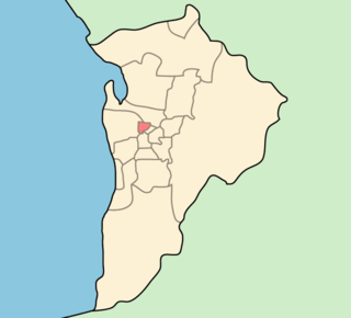
The City of Port Adelaide Enfield, located across inner north and north-western suburbs of Adelaide, is one of the largest metropolitan councils within South Australia. It was established on 26 March 1996 by the amalgamation of the City of Port Adelaide and the City of Enfield.

Yatala Labour Prison prison in Northfield, South Australia

Yatala Labour Prison is a high-security men's prison located in the north-eastern part of the northern suburb Northfield in Adelaide, South Australia, Australia. It was built in 1854 to enable prisoners to work at the creek, quarrying rock for roads and construction. Originally known as The Stockade it acquired its current name from a local Aboriginal word.

City of Prospect Local government area in South Australia

The City of Prospect is an inner urban local government area (LGA) in Adelaide, South Australia. The council seat is the unusually-large suburb of Prospect, which makes up almost two thirds of the tiny council area which is less than 8km2. Established in 1872, it is one of the oldest local government bodies in South Australia.

City of Salisbury Local government area in South Australia

The City of Salisbury is a local government area (LGA) located on the northern fringes of Adelaide, South Australia. It had population of 137,979 people in 2016 and encompasses an area of 158 km². The council's main offices are situated in the Salisbury central business district. Geographically, the region is located on the outskirts of Adelaide. In recent years the council has become a leader in water management and the use of recycled water.

Northfield, South Australia Suburb of Adelaide, South Australia

Northfield is a suburb of the greater Adelaide, South Australia area.

Ferryden Park, South Australia Suburb of Adelaide, South Australia

Ferryden Park is a north-western suburb of Adelaide 6.3 km from the central business district, in the state of South Australia, Australia. Situated in the City of Port Adelaide Enfield local government area, it is adjacent to Kilkenny, Angle Park, Woodville Gardens, Croydon Park, and Regency Park. It is bounded to the north by Murray Street, west by Liberty Grove and Hassell Street, south by Regency Road and to the east by Days Road.

Clearview, South Australia Suburb of Adelaide, South Australia

Clearview is a suburb of Adelaide, South Australia about 8 km north of the Adelaide city centre. The rectangular suburb is bordered by Grand Junction Road on the north, Hampstead Road on the east, Collins Street, Broadview on the south, and the suburb of Enfield on the west.

City of Enfield Local government area in South Australia

The City of Enfield was a local government area of South Australia from 1868 to 1996. It was known as Yatala South up until 1933, which was named for its local government area predecessor, the District Council of Yatala, and known as Enfield thereafter.

Yatala Vale is an outer northeastern rural suburb of Adelaide, South Australia. It is located in the City of Tea Tree Gully local government area, and is adjacent to Golden Grove and Fairview Park, as well as the rural districts of Upper Hermitage and Gould Creek.

Valley View, South Australia Suburb of Adelaide, South Australia

Valley View is a suburb of Adelaide, South Australia. It is located mainly in the City of Salisbury and the City of Port Adelaide Enfield, with part also in the City of Tea Tree Gully. The suburb's boundaries are defined by the intersection of Walkleys, Grand Junction and North East Roads in the south, and Wright and Kelly Roads in the north and east.

City of Port Adelaide Local government area in South Australia

The City of Port Adelaide was a local government area of South Australia centred at the port of Adelaide from 1855 to 1996.

Hundred of Yatala Cadastral in South Australia

The Hundred of Yatala is a cadastral unit of hundred in South Australia covering much of the Adelaide metropolitan area north of the River Torrens. It is one of the eleven hundreds of the County of Adelaide stretching from the Torrens in the south to the Little Para River in the north; and spanning from the coast in the west to the Adelaide foothills in the east. It is roughly bisected from east to west by Dry Creek. It was named in 1846 by Governor Frederick Robe, Yatala being likely derived from 'yartala', an indigenous word referring to the flooded state of the plain either side of Dry Creek after heavy rain.

Hundred of Munno Para Cadastral in South Australia

The Hundred of Munno Para is a cadastral unit of hundred covering the outer northern suburbs of Adelaide north of the Little Para River and the flanking semi-rural areas in South Australia. It is one of the eleven hundreds of the County of Adelaide. It was named in 1846 by Governor Frederick Robe, Munno Para being a term from a local Kaurna Aboriginal people meaning golden wattle creek. This name refers to either the Gawler River or the Little Para River.

Hundred of Port Adelaide Cadastral in South Australia

The Hundred of Port Adelaide is a cadastral hundred covering the vicinity of Port Adelaide, Lefevre Peninsula and the coast of the central Adelaide Plains south of Gawler River and west of Port Wakefield Road. It is one of the eleven hundreds of the County of Adelaide and was named in 1846 by Governor Frederick Robe.

District Council of Hindmarsh Local government area in South Australia

The District Council of Hindmarsh was a local government area in South Australia from 1853 to 1875, seated at the inner north west Adelaide suburb of Hindmarsh.

City of Woodville Local government area in South Australia

The City of Woodville was a local government area in South Australia from 1875 to 1993, seated at the inner north west Adelaide suburb of Woodville.

District Council of Queenstown and Alberton Local government area in South Australia

The District Council of Queenstown and Alberton was a local government area of South Australia established in 1864 and abolished in 1898.

District Council of Rosewater Local government area in South Australia

The District Council of Rosewater was a local government area of South Australia immediately east of Port Adelaide from 1877 to 1899.