Burra is a pastoral centre and historic tourist town in the mid-north of South Australia. It lies east of the Clare Valley in the Bald Hills range, part of the northern Mount Lofty Ranges, and on Burra Creek. The town began as a single company mining township that, by 1851, was a set of townships collectively known as "The Burra". The Burra mines supplied 89% of South Australia's and 5% of the world's copper for 15 years, and the settlement has been credited with saving the economy of the struggling new colony of South Australia. The Burra Burra Copper Mine was established in 1848 mining the copper deposit discovered in 1845. Miners and townspeople migrated to Burra primarily from Cornwall, Wales, Scotland and Germany. The mine first closed in 1877, briefly opened again early in the 20th century and for a last time from 1970 to 1981.

Eudunda is a rural town in South Australia, roughly 103 kilometres northeast of Adelaide, established in 1870 after settlers began moving into the area in the 1860s. As of the 2006 census, Eudunda had a population of 640.
The North Eastern Football League is an Australian rules football competition based in the Mid North region of South Australia, Australia. It is an affiliated member of the South Australian National Football League. 8 teams are in the league. The most recent team to join the comp is the Southern Saints (Eudunda/Robertstown) who joined in 2010. Except the Eudunda Rosters were an original team in the NEFL. Only in 2010 'Robertstown "Roos" joined in with the NEFL.

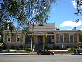
The Regional Council of Goyder is a local government area located in the Mid North region of South Australia. The council area is reliant on agriculture as a mainstay of its economy, with manufacturing and tourism also becoming prominent. The council seat lies at Burra, with a branch office situated at Eudunda.

Robertstown is a town in South Australia. The town is located 23 kilometres (14 mi) north of Eudunda, in the Regional Council of Goyder. At the 2006 census, Robertstown and the surrounding area had a population of 318. Robertstown is named for the John Roberts, the first postmaster in the area, who laid out the town in 1871. It was previously known as Emu Flats and Roberts Town.
Burra was an electoral district of the House of Assembly in the Australian state of South Australia from 1875 to 1902, and again from 1938 to 1970.

Bundey is a locality in the Mid North region of South Australia. It is located on Goyder's Line, on the plains between Burra and Morgan in the Regional Council of Goyder. The bounded locality of Bundey corresponds to the boundaries of the cadastral Hundred of Bundey, except for the southwestern corner of the Hundred which is the northeastern corner of the locality of Geranium Plains. Bundey was named in 1878 for politician William Henry Bundey.

Mongolata is a rural locality in the Mid North region of South Australia, situated in the Regional Council of Goyder. The modern locality was established in August 2000, when boundaries were formalised for the "long established local name".
The District Council of Robertstown was a local government area in South Australia from 1932 to 1997. The central town and council seat was Robertstown.

The District Council of Eudunda was a local government area in South Australia from 1932 to 1997. The central town and council seat was Eudunda. It was established on 12 May 1932 with the amalgamation of the District Council of Julia and the District Council of Neales. By 1936, it was divided up into four wards: Brownlow, Eudunda and Neales and Julia. It met at the District Hall at Eudunda, which had formerly been owned by the Neales council, until 1963. The council existed until 1997, when it amalgamated with the District Council of Burra Burra, the District Council of Hallett and the District Council of Robertstown to form the Regional Council of Goyder.
The District Council of Hallett was a local government area in South Australia from 1877 to 1997.
The District Council of Mount Bryan was a local government area in South Australia from 1874 to 1935.
County of Burra is a cadastral unit located in the Australian state of South Australia which covers land located in the state’s east associated with the town of Burra. It was proclaimed in 1851 by Governor Young and named after the town of Burra.
The District Council of Booborowie was a local government area in South Australia from 1875 to 1935.
The District Council of Hanson was a local government area in South Australia from 1878 to 1935.
The District Council of Burra was a local government area in South Australia from 1872 to 1935.
Baldina is a rural locality in the Mid North region of South Australia, situated in the Regional Council of Goyder. It was established in August 2000, when boundaries were formalised for the "long established local name".
Willalo is a rural locality in the Mid North region of South Australia, situated in the Regional Council of Goyder. It was established in August 2000, when boundaries were formalised for the "long established local name". It was also known in its early days as North Booboorowie.
The Local Government Areas (Re-arrangement) Acts 1929 and 1931 were acts of the Parliament of South Australia. The application of the acts, via recommendations of the commission of the same name, led to the statewide re-arrangement of local government areas, effected from 1932 to 1935.

County of Kimberley is a cadastral unit located in the Australian state of South Australia that covers land to the east of the Flinders Ranges about 45 kilometres (28 mi) east of the town of Peterborough. It was proclaimed in 1871 and named after John Wodehouse, 1st Earl of Kimberley, a British Secretary of State for the Colonies. It has been partially divided in the following sub-units of hundreds – Gumbowie, Hardy, Ketchowla, Parnaroo, Terowie and Wonna.