Lindley, South Australia

Last updated

Lindley
South Australia
Australia South Australia location map.svg
Red pog.svg
Lindley
Coordinates 33°53′13″S139°36′47″E / 33.88707°S 139.612931°E / -33.88707; 139.612931 Coordinates: 33°53′13″S139°36′47″E / 33.88707°S 139.612931°E / -33.88707; 139.612931 [1]
Population4 (2016 census) [2]
Established1881
Postcode(s) 5320
LGA(s) Mid Murray Council
Region Murray and Mallee [1]
County Burra [1]
State electorate(s) Stuart
Federal Division(s) Barker
Mean max temp [3] Mean min temp [3] Annual rainfall [3]
25.3 °C
78 °F
9.3 °C
49 °F
281.5 mm
11.1 in
Localities around Lindley:
Warnes Warnes Bunyung
Maude Lindley Stuart
Beatty Eba Morgan

Lindley is a locality in Mid Murray Council in the Mid North of South Australia, north of Morgan, South Australia. Its boundaries are coincident with the cadastral Hundred of Lindley in the County of Burra. The Goyder Highway traverses the southwestern corner of the locality.

Mid Murray Council Local government area in South Australia

The Mid Murray Council is a local government area in South Australia in the Murray and Mallee region of South Australia. The council spans the area from the Riverland through the Murraylands to the eastern slopes of the Mount Lofty Ranges. It includes 220 km of the Murray River. The council seat is at Mannum; it also maintains secondary offices at Cambrai and Morgan.

Mid North region of South Australia

The Mid North is a region of South Australia, north of the Adelaide Plains, but not as far north as the Far North, or the outback. It is generally accepted to extend from Spencer Gulf east to the Barrier Highway, including the coastal plain, the southern part of the Flinders Ranges, and the northern part of the Mount Lofty Ranges. The area was settled as early as 1840 and provided early farming and mining outputs for the fledgling colony. Farming is still significant in the area, particularly wheat, sheep and grapevines. There are not currently any significant mining activities in the Mid North.

South Australia State of Australia

South Australia is a state in the southern central part of Australia. It covers some of the most arid parts of the country. With a total land area of 983,482 square kilometres (379,725 sq mi), it is the fourth-largest of Australia's states and territories by area, and fifth largest by population. It has a total of 1.7 million people, and its population is the second most highly centralised in Australia, after Western Australia, with more than 77 percent of South Australians living in the capital, Adelaide, or its environs. Other population centres in the state are relatively small; Mount Gambier, the second largest centre, has a population of 28,684.

The locality boundaries were set in March 2003 to conform to the Hundred boundaries. [4] The Hundred was named in 1881 for John Lindley, a botanist and horticulturalist who was assistant librarian for Sir Joseph Banks and Professor of Botany at London University. [5]

John Lindley English botanist, gardener and orchidologist (1799–1865)

John Lindley FRS was an English botanist, gardener and orchidologist.

Joseph Banks English naturalist, botanist and patron of the natural sciences

Sir Joseph Banks, 1st Baronet, was an English naturalist, botanist, and patron of the natural sciences.

Much of the land was selected by settlers in 1881 soon after the Hundred was surveyed for closer settlement. It was bought from the government for a basic price of £1 per acre plus any existing improvements, and the buyers were named in the Government Gazette. [6] Land was able to be bought on credit, and the buyer given time to improve the land before needing to make the payment for their land.

The South Australian Government Gazette is the government gazette of the South Australian Government. First printed on 20 June 1839, the South Australian Government chose to have its own publication rather than using the local newspaper, South Australian Gazette and Colonial Register because the publishers were perceived as politically biased. The purpose was to publish government orders and acts with authority of the colonial secretary. Initially it was called South Australian Gazette.

The 2016 Australian census which was conducted in August 2016 reports that Lindley had a population of four people. [2]

The 2016 Australian census was the seventeenth national population census held in Australia. The census was officially conducted with effect on Tuesday, 9 August 2016. The total population of the Commonwealth of Australia was counted as 23,401,892 – an increase of 8.8 per cent or 1,894,175 people since the 2011 census. Norfolk Island joined the census for the first time in 2016, adding 1,748 to the population.

Related Research Articles

Ki Ki, South Australia Town in South Australia

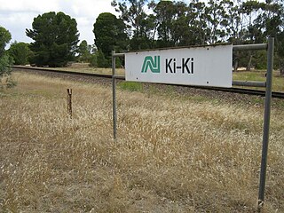
Ki Ki is a small town in South Australia. It is on the Dukes Highway (A8) adjacent to the Adelaide-Melbourne railway, the main links between Adelaide and Melbourne. The town is the primary settlement for the Hundred of Livingston.

Penong, South Australia Town in South Australia

Penong is a small South Australian town on the Nullarbor Plain. It is the last town on the Eyre Highway before Border Village which makes it a popular rest-stop for travellers.

Bruce, South Australia Town in South Australia

Bruce is a town and a locality in the Australian state of South Australia.

Cooltong, South Australia Town in South Australia

Cooltong is a town and locality in the Australian state of South Australia. At the 2011 census, Cooltong had a population of 317.

Kongorong, South Australia Town in South Australia

Kongorong is a locality in the Australian state of South Australia located southwest of Mount Gambier. It has an Australian rules football team and netball team. Kongorong Primary School had 61 students in 2010.

Overland Corner Town in South Australia

Overland Corner is a locality in the Australian state of South Australia located in the state’s east about 181 kilometres (112 mi) north-east of the state capital of Adelaide and about 30 kilometres (19 mi) west of the municipal seat in Berri.

Peebinga, South Australia Town in South Australia

Peebinga is a town and locality in the Australian state of South Australia. Peebinga was the terminus of the Peebinga railway line which was built in 1914 as part of a major state government project to open up the Murray Mallee for grazing and cropping.

Andrews, South Australia Town in South Australia

Andrews is a rural locality in the Northern Areas Council of South Australia, located on the Hill River. Its boundaries were formalised in April 2001 for the long established name for the area. The district, which is primarily dedicated to primary production, mainly grain farming, is in the Spalding Ward of the council. The township has bulk grain handling and storage facilities as well as limited sporting and community facilities. The Hill River Road and the Hill River run north-south through the locality, while Andrews Road runs east-west, connecting the Goyder Highway with RM Williams Way. In the 2011 census, the population of Andrews was too low to separately report; it was included in that of adjacent Spalding.

Bagot Well, South Australia Town in South Australia

Bagot Well is a locality around 6 km north-east of Kapunda, South Australia on the road to Eudunda and was named for Captain C. H. Bagot, who owned a great deal of property in the area.

Ucolta, South Australia Town in South Australia

Ucolta is a locality in the Mid North region of South Australia. It is named for a railway station on the Broken Hill-Port Pirie railway line. Trains no longer stop at Ucolta. It is also where the Barrier Highway first meets the railway line, and the Wilmington–Ucolta Road which connects across the northern side of the Mid North, providing the shortest road route from Western Australia and Eyre Peninsula via Port Augusta to Broken Hill and New South Wales.

Gluepot, South Australia Suburb of Pastoral Unincorporated Area, South Australia

Gluepot is a locality in the Australian state of South Australia located about 180 kilometres north-east of the state capital of Adelaide and about 40 kilometres to the north of the town of Waikerie.

Ulooloo, South Australia Suburb of Regional Council of Goyder, South Australia

Ulooloo is a locality in the Mid North of South Australia. It is midway between Burra and Peterborough on the Barrier Highway from Adelaide to Broken Hill, New South Wales.

Hammond, South Australia Town in South Australia

Hammond is a town and locality in the Australian state of South Australia located in the southern Flinders Ranges.

County of Burra Cadastral in South Australia

County of Burra is a cadastral unit located in the Australian state of South Australia which covers land located in the state’s east associated with the town of Burra. It was proclaimed in 1851 by Governor Young and named after the town of Burra.

Walloway, South Australia Town in South Australia

Walloway is a locality in the Australian state of South Australia located about 255 kilometres (158 mi) north of the state capital of Adelaide and about 10 kilometres (6.2 mi) north of the municipal seat of Orroroo.

Willalooka, South Australia Town in South Australia

Willalooka is a small service town and locality in the Limestone Coast region of South Australia. it is located on the Riddoch Highway between Keith and Padthaway. Christmas Rocks Conservation Park is north of the town adjacent to the highway.

County of Jervois Cadastral in South Australia

The County of Jervois is a cadastral unit in the Australian state of South Australia that covers land on the east coast of the Eyre Peninsula. It was proclaimed on 24 January 1878 and named after William Jervois, the Governor of South Australia from October 1877 to January 1883.

Caralue, South Australia Town in South Australia

Caralue is a locality on Eyre Peninsula in South Australia. It is approximately coincident with the Hundred of Caralue except for the southeastern corner and a notch in the north side of the hundred that are in the localities of Waddikee and Panitya respectively.

Maude, South Australia Town in South Australia

Maude is a locality on the Goyder Highway in the Mid North region of South Australia.

Pooginook, South Australia Suburb of District Council of Loxton Waikerie, South Australia

Pooginook is a locality in the Australian state of South Australia located in the state’s east about 167 kilometres (104 mi) north-east of the state capital of Adelaide and about 60 kilometres (37 mi) north-west of the municipal seat in Loxton.

References

  1. 1 2 3 "Search results for 'Lindley, LOCB" with the following datasets selected – 'Suburbs and Localities', 'Counties', 'Local Government Areas', 'SA Government Regions' and 'Gazetteer'". Location SA Map Viewer. Government of South Australian. Retrieved 1 December 2018.
  2. 1 2 Australian Bureau of Statistics (27 June 2017). "Lindley (State Suburb)". 2016 Census QuickStats. Retrieved 1 December 2018. OOjs UI icon edit-ltr-progressive.svg
  3. 1 2 3 "Summary (climate) statistics GLUEPOT RESERVE (GLUEPOT) (nearest weather station)". Commonwealth of Australia , Bureau of Meteorology . Retrieved 1 December 2018.
  4. "Placename Details: Lindley". Property Location Browser Report. 19 June 2008. SA0031945. Archived from the original on 12 October 2016. Retrieved 19 March 2017.
  5. "Placename Details: Hundred of Lindley". Property Location Browser Report. 29 January 2009. SA0039512. Archived from the original on 12 October 2016. Retrieved 19 March 2017.
  6. "Newly-opened Country Lands" (PDF). South Australian Government Gazette . 15 December 1881. pp. 1789–1790 (PDF pages 45–46). No. 54. Retrieved 19 March 2017.