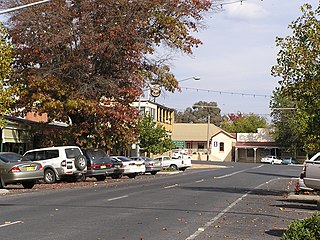
Tumbarumba is a small town in New South Wales, Australia, about 480 kilometres (300 mi) southwest of the state capital, Sydney. Tumbarumba is located on the periphery of the Riverina and South West Slopes regions at the western edge of the Snowy Mountains. The 2016 census showed the population of the town and surrounding area to be 1,862 people. Locals refer to the town as 'Tumba'.

The Mid Murray Council is a local government area in South Australia in the Murray and Mallee region of South Australia. The council spans the area from the Riverland through the Murraylands to the eastern slopes of the Mount Lofty Ranges. It includes 220 km of the Murray River. The council seat is at Mannum; it also maintains secondary offices at Cambrai and Morgan.

Birdwood is a town near Adelaide, South Australia. It is located in the local government areas of the Adelaide Hills Council and the Mid Murray Council.

Truro is a town in South Australia, 80 km northeast of Adelaide. It is situated in an agricultural and pastoral district on the Sturt Highway, east of the Barossa Valley, where the highway crosses somewhat lofty and rugged parts of the Mount Lofty Ranges. At the 2011 census, Truro had a population of 395.

Alexandrina Council is a local government area in the Fleurieu and Kangaroo Island region of South Australia. The Alexandrina Council was formed on 1 July 1997 by the amalgamation of the District Council of Port Elliot and Goolwa, the District Council of Strathalbyn and a portion of the District Council of Willunga. The council is divided into five wards: Nangkita Kuitpo, Angas Bremer, Port Elliot Middleton, Strathalbyn and Goolwa Hindmarsh Island.

Gormanston is a town in Tasmania on the slopes of Mount Owen, above the town of Queenstown in Tasmania's West Coast. At the 2016 Gormanston had a population of 17.

Mount Perry is a small town and locality in the North Burnett Region in southeastern Queensland, Australia. In the 2016 census, Mount Perry had a population of 538 people. The neighbourhood of Drummers Creek is in the locality.

Angaston is a town on the eastern side of the Barossa Valley in South Australia, 77 km northeast of Adelaide. Its elevation is 347 m, one of the highest points in the valley, and has an average rainfall of 561 mm. Angaston was originally known as German Pass, but was later renamed after the politician, banker and pastoralist George Fife Angas, who settled in the area in the 1850s. Angaston is in the Barossa Council local government area, the state electoral district of Schubert and the federal Division of Barker.

Eudunda is a rural town in South Australia, roughly 103 kilometres northeast of Adelaide, established in 1870 after settlers began moving into the area in the 1860s. As of the 2006 census, Eudunda had a population of 640.
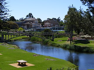
Strathalbyn is a town in South Australia, in the Alexandrina Council. As of 2016, the town had a population of approximately 6,500.

Mount Torrens is a town in the eastern Adelaide Hills region of South Australia, 46 kilometres east-north-east of the state capital, Adelaide and 8 km east of Lobethal. It is located in the Adelaide Hills Council and the Mid Murray Council local government areas. At the 2006 census, Mount Torrens had a population of 337.

Khancoban is a small town in Snowy Valleys Council, New South Wales, Australia. The town is located 567 kilometres (352 mi) from the state capital, Sydney and 13 kilometres (8 mi) from the state border with Victoria, in the foothills of the Snowy Mountains, near the upper reaches of the Murray River. At the 2016 census, Khancoban had a population of 304.

Tooleybuc is a town in the western Riverina district of New South Wales, Australia. The town is located on the Mallee Highway, 919 kilometres (571 mi) south west of the state capital, Sydney and 381 kilometres (237 mi) north west of Melbourne. Situated on the banks of the Murray River across from Piangil in the neighbouring state of Victoria, at the 2011 census, Tooleybuc has a population of 176. The town is in the Murray River Council local government area.
The River Angas, part of the River Murray catchment, is a river that is located in the Adelaide Hills region in the Australian state of South Australia.

Burrinjuck is a village community in the far eastern part of the Riverina. It is situated by road, about 15 kilometres southwest from Woolgarlo and 28 kilometres south from Bookham. The name of the town is derived from an Aboriginal word meaning 'mountain with a rugged top'. At the 2016 census, the Burrinjuck area had a population of 19.
Black Hill is a settlement in South Australia. Black Hill is between the Mount Lofty Ranges and the Murray River on the banks of the Marne River. Until 1918, when many place names were changed if they sounded German, Black Hill was known as Friedensthal.
Alexander James "Alick" Murray was a pastoralist and sheep breeder of South Australia.
John Hill was an English explorer of South Australia and part of the European exploration of Australia. Hill was the first European to see and traverse the Clare Valley.

The District Council of Ridley-Truro was a local government area in South Australia from 1991 to 1997.
The District Council of Mount Pleasant was a local government area in South Australia from 1935 to 1997. The council seat was located at Mount Pleasant.
