
Kenton Valley is a locality named for a valley located between Gumeracha and Lobethal, about 40 km east of Adelaide, South Australia. It is located in the Adelaide Hills Council local government area.
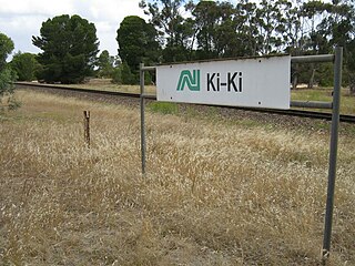
Ki Ki is a small town in South Australia. It is on the Dukes Highway (A8) adjacent to the Adelaide-Melbourne railway, the main links between Adelaide and Melbourne. The town is the primary settlement for the Hundred of Livingston.
Bruce is a town and a locality in the Australian state of South Australia.
Cooltong is a town and locality in the Australian state of South Australia. At the 2011 census, Cooltong had a population of 317.

Kongorong is a locality in the Australian state of South Australia located southwest of Mount Gambier. It has an Australian rules football team and netball team. Kongorong Primary School had 61 students in 2010.

Marananga is a locality in South Australia. It was known as Gnadenfrei before 1918 when names of "enemy origin" were changed to sound less German.
Nurragi is a locality on Fleurieu Peninsula in South Australia. It was named for and served by the Nurragi railway station which in turn was derived from a native name for scrub. The station and railway alignment are now the Nurragi Conservation Reserve.
Peebinga is a town and locality in the Australian state of South Australia. Peebinga was the terminus of the Peebinga railway line which was built in 1914 as part of a major state government project to open up the Murray Mallee for grazing and cropping.
Bagot Well is a locality around 6 km north-east of Kapunda, South Australia on the road to Eudunda and was named for Captain C. H. Bagot, who owned a great deal of property in the area.
Lower Light is a township adjacent to Port Wakefield Road in South Australia's lower Mid North. The township of Port Prime was surveyed on the coast of Gulf St Vincent in 1880, but little remains of that town now, and it is included as part of the bounded locality of Lower Light.
Hammond is a town and locality in the Australian state of South Australia located in the southern Flinders Ranges.

Mount Mary is a small town on the Thiele Highway between Eudunda and Morgan in South Australia. It was also served by the Morgan railway line from 1878 until 1969 and is named for the Mount Mary railway station on that line.

County of Burra is a cadastral unit located in the Australian state of South Australia which covers land located in the state’s east associated with the town of Burra. It was proclaimed in 1851 by Governor Young and named after the town of Burra.
Willalooka is a small service town and locality in the Limestone Coast region of South Australia. it is located on the Riddoch Highway between Keith and Padthaway. Christmas Rocks Conservation Park is north of the town adjacent to the highway.
Lindley is a locality in Mid Murray Council in the Mid North of South Australia, north of Morgan, South Australia. Its boundaries are coincident with the cadastral Hundred of Lindley in the County of Burra. The Goyder Highway traverses the southwestern corner of the locality.

The County of Jervois is a cadastral unit in the Australian state of South Australia that covers land on the east coast of the Eyre Peninsula. It was proclaimed on 24 January 1878 and named after William Jervois, the Governor of South Australia from October 1877 to January 1883.
Mitchell is a locality on Eyre Peninsula in South Australia. Its boundaries were set to roughly the northern two thirds of the Hundred of Mitchell, from which it draws its name, in 2003. Mitchell includes the former locality of Lake Brimpton, adjacent to a lake by the same name. The Lake Brimpton school opened in 1932 but has now closed.
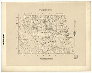
The Hundred of Townsend is a cadastral unit of hundred located in the Limestone Coast region in the south-east of South Australia.
Pallamana is a locality in the Murraylands region of South Australia between the Mount Lofty Ranges and the Murray River, northwest of Murray Bridge.
Hay Valley is a small locality in South Australia, 2.7 kilometres (1.7 mi) north of Nairne. It overlies the geographical feature of the same name and was originally established as a named subsection within the Hundred of Kanmantoo. In 2016 the population was 25.
