
Traralgon is a town located in the east of the Latrobe Valley in the Gippsland region of Victoria, Australia. The urban population of Traralgon at the 2016 census was 25,485. It is the largest and fastest growing city in the greater Latrobe Valley area, which has a population of 74,170 at June 2016 and is administered by the City of Latrobe.

Morwell is a town in the Latrobe Valley area of Gippsland, in South-Eastern Victoria, Australia approximately 149 km (93 mi) east of Melbourne.

The City of Lake Macquarie is a local government area in Greater Newcastle and part of the Hunter Region in New South Wales, Australia. It was proclaimed a city from 7 September 1984. The area is situated adjacent to the city of Newcastle and is part of the Greater Newcastle Area. The city is approximately 150 km (93 mi) north of Sydney. One of its major tourist attractions is its lake, also named Lake Macquarie.

The Latrobe Valley is an inland geographical district and urban area of the Gippsland region in the state of Victoria, Australia. The traditional owners are the Brayakaulung of the Gunai nation. The district lies east of Melbourne and nestled between the Strzelecki Ranges to the south and the Baw Baw Ranges, part of the Great Dividing Range, to the north. Mount St Phillack is the highest peak to the north of the Latrobe Valley, due north of Moe. The highest peak to the south is Mt Tassie, south of Traralgon.
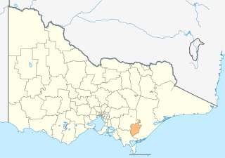
The City of Latrobe is a local government area in the Gippsland region in eastern Victoria, Australia, located in the eastern part of the state. It covers an area of 1,426 square kilometres (551 sq mi) and in June 2018 had a population of 75,211. It is primarily urban with the vast majority of its population living within the four major urban areas of Moe, Morwell, Traralgon, and Churchill, and other significant settlements in the LGA include Boolarra, Callignee, Glengarry, Jeeralang, Newborough, Toongabbie, Tyers, Yallourn North and Yinnar. It was formed in 1994 from the amalgamation of the City of Moe, City of Morwell, City of Traralgon, Shire of Traralgon, and parts of the Shire of Narracan and Shire of Rosedale. The Yallourn Works Area was added in 1996. When formed, the municipality was called the Shire of La Trobe, but on 6 April 2000, it adopted its current name.

Endeavour Hills is a suburb in Melbourne, Victoria, Australia, 31 km (19 mi) south-east from Melbourne's central business district. Its local government area is the City of Casey. At the 2016 census, Endeavour Hills had a population of 24,294.

Mont Albert is an inner eastern suburb of Melbourne, Victoria, Australia, 12 kilometres east of Melbourne's Central Business District. Its local government area are the Cities of Boroondara and Whitehorse. At the 2016 Census, Mont Albert had a population of 4,840.

Newport is an suburb of Melbourne, Victoria, Australia, 10 km south-west of the Melbourne central business district, located within the City of Hobsons Bay local government area. Newport had a population of 12,916 at the 2016 Census.

Dimboola is a town in the Shire of Hindmarsh in the Wimmera region of western Victoria, Australia, 334 kilometres north-west of Melbourne. At the Australian 2016 census Dimboola had a population of 1,424.

Ararat is a city in south-west Victoria, Australia, about 198 kilometres (120 mi) west of Melbourne, on the Western Highway on the eastern slopes of the Ararat Hills and Cemetery Creek valley between Victoria's Western District and the Wimmera. Its urban population according to 2016 census is 8,297 and services the region of 11,752 residents across the Rural City's boundaries. It is also the home of the 2018/19 GMGA Golf Championship Final.

Patterson Lakes is located in outer south-east Melbourne in Victoria, Australia. The canal suburb is located 35 km southeast of Melbourne's central business district. Its local government area is the City of Kingston. In the 2016 census, Patterson Lakes had a population of 7,564.
Hazelwood or Hazlewood may refer to:

Collie is a town in the South West region of Western Australia, 213 kilometres (132 mi) south of the state capital, Perth, and 59 kilometres (37 mi) inland from the regional city and port of Bunbury. It is near the junction of the Collie and Harris Rivers, in the middle of dense jarrah forest and the only coalfields in Western Australia. At the 2016 census, Collie had a population of 7,192.
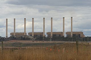
The Hazelwood Power Station is a decommissioned brown coal-fuelled thermal power station located in the Latrobe Valley of Victoria, Australia. Built between 1964 and 1971, the 1,600-megawatt-capacity power station was made up of eight 200MW units, and supplied up to 25% of Victoria's base load electricity and more than 5% of Australia's total electricity demand. It was a 'subcritical' pulverized coal-fired boiler. The station was listed as the least carbon efficient power station in the OECD in a 2005 report by WWF Australia, making it one of the most polluting power stations in the world. At 1.56 tonnes of CO2 for each megawatt hour of electricity, it was 50% more polluting than the average black coal power station in New South Wales or Queensland. Hazelwood emitted 14% of Victoria's annual greenhouse gas emissions and 3% of Australia's greenhouse gas emissions.
Hazelwood North is a locality in Victoria, Australia. It has a population of 1220.

Barham is a town in the western Riverina district of New South Wales, Australia. The town is located 823 kilometres south west of the state capital, Sydney and 303 kilometres north west of Melbourne. Situated on the banks of the Murray River across from Koondrook in the neighbouring state of Victoria, Barham had a population of 1,159 at the 2016 census. The town is in the Murray River Council local government area.

Riverhills is a south-western suburb in the City of Brisbane, Queensland, Australia. It is one of the Centenary suburbs. In the 2016 census, Riverhills had a population of 4,042 people.

Yinnar is a rural township located in the Latrobe Valley, in central Gippsland, Victoria, Australia. At the 2016 census, Yinnar had a population of 907. The origin of the name Yinnar is believed to have been derived from the local Aboriginal term yinnar, meaning "woman".
Loch Sport is a coastal tourist town situated on the Ninety Mile Beach and Lake Victoria in Central Gippsland, eastern Victoria, Australia. At the 2016 census it had a permanent resident population of 814. This is an increase of 125 from the 2011 census. Though the number swells to 7,000 during the Easter and Christmas holidays.
Churchill is a town in the Latrobe Valley, located in central Gippsland in the east of Victoria, Australia. The town had a population of 4,568 at the 2016 census, and is part of the Latrobe City local government area. The town was named in honour of former British prime minister Sir Winston Churchill, who had died earlier in the year the town's establishment was announced.
