Sandown Park | ||||||||||||||||||||||||||||||||||||||||||||||||||||||||
|---|---|---|---|---|---|---|---|---|---|---|---|---|---|---|---|---|---|---|---|---|---|---|---|---|---|---|---|---|---|---|---|---|---|---|---|---|---|---|---|---|---|---|---|---|---|---|---|---|---|---|---|---|---|---|---|---|
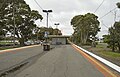
 South-east bound view from Platform 2, October 2024 | ||||||||||||||||||||||||||||||||||||||||||||||||||||||||
| General information | ||||||||||||||||||||||||||||||||||||||||||||||||||||||||
| Location | Lightwood Road, Springvale, Victoria 3171 City of Greater Dandenong Australia | |||||||||||||||||||||||||||||||||||||||||||||||||||||||
| Coordinates | 37°57′24″S145°09′48″E / 37.9568°S 145.1632°E | |||||||||||||||||||||||||||||||||||||||||||||||||||||||
| System | PTV commuter rail station | |||||||||||||||||||||||||||||||||||||||||||||||||||||||
| Owned by | VicTrack | |||||||||||||||||||||||||||||||||||||||||||||||||||||||
| Operated by | Metro Trains | |||||||||||||||||||||||||||||||||||||||||||||||||||||||
| Lines | ||||||||||||||||||||||||||||||||||||||||||||||||||||||||
| Distance | 25.68 kilometres from Southern Cross | |||||||||||||||||||||||||||||||||||||||||||||||||||||||
| Platforms | 2 (1 island) | |||||||||||||||||||||||||||||||||||||||||||||||||||||||
| Tracks | 2 | |||||||||||||||||||||||||||||||||||||||||||||||||||||||
| Construction | ||||||||||||||||||||||||||||||||||||||||||||||||||||||||
| Structure type | At-grade | |||||||||||||||||||||||||||||||||||||||||||||||||||||||
| Parking | 250 spaces | |||||||||||||||||||||||||||||||||||||||||||||||||||||||
| Bicycle facilities | Yes | |||||||||||||||||||||||||||||||||||||||||||||||||||||||
| Accessible | No — steep ramp | |||||||||||||||||||||||||||||||||||||||||||||||||||||||
| Other information | ||||||||||||||||||||||||||||||||||||||||||||||||||||||||
| Status | Operational, unstaffed | |||||||||||||||||||||||||||||||||||||||||||||||||||||||
| Station code | SNP | |||||||||||||||||||||||||||||||||||||||||||||||||||||||
| Fare zone | Myki Zone 2 | |||||||||||||||||||||||||||||||||||||||||||||||||||||||
| Website | Public Transport Victoria | |||||||||||||||||||||||||||||||||||||||||||||||||||||||
| History | ||||||||||||||||||||||||||||||||||||||||||||||||||||||||
| Opened | 19 June 1965 | |||||||||||||||||||||||||||||||||||||||||||||||||||||||
| Electrified | December 1922 (1500 V DC overhead) | |||||||||||||||||||||||||||||||||||||||||||||||||||||||
| Previous names | Oakleigh Racecourse (1889-1892) | |||||||||||||||||||||||||||||||||||||||||||||||||||||||
| Passengers | ||||||||||||||||||||||||||||||||||||||||||||||||||||||||
| 2005–2006 | 415,698 [1] | |||||||||||||||||||||||||||||||||||||||||||||||||||||||
| 2006–2007 | 466,021 [1] | |||||||||||||||||||||||||||||||||||||||||||||||||||||||
| 2007–2008 | 455,989 [1] | |||||||||||||||||||||||||||||||||||||||||||||||||||||||
| 2008–2009 | 404,270 [2] | |||||||||||||||||||||||||||||||||||||||||||||||||||||||
| 2009–2010 | 440,579 [2] | |||||||||||||||||||||||||||||||||||||||||||||||||||||||
| 2010–2011 | 443,853 [2] | |||||||||||||||||||||||||||||||||||||||||||||||||||||||
| 2011–2012 | 411,211 [2] | |||||||||||||||||||||||||||||||||||||||||||||||||||||||
| 2012–2013 | Not measured [2] | |||||||||||||||||||||||||||||||||||||||||||||||||||||||
| 2013–2014 | 526,464 [2] | |||||||||||||||||||||||||||||||||||||||||||||||||||||||
| 2014–2015 | 504,513 [1] | |||||||||||||||||||||||||||||||||||||||||||||||||||||||
| 2015–2016 | 571,573 [2] | |||||||||||||||||||||||||||||||||||||||||||||||||||||||
| 2016–2017 | 607,300 [2] | |||||||||||||||||||||||||||||||||||||||||||||||||||||||
| 2017–2018 | 527,513 [2] | |||||||||||||||||||||||||||||||||||||||||||||||||||||||
| 2018–2019 | 537,382 [2] | |||||||||||||||||||||||||||||||||||||||||||||||||||||||
| 2019–2020 | 443,950 [2] | |||||||||||||||||||||||||||||||||||||||||||||||||||||||
| 2020–2021 | 178,800 [2] | |||||||||||||||||||||||||||||||||||||||||||||||||||||||
| 2021–2022 | 189,600 [3] | |||||||||||||||||||||||||||||||||||||||||||||||||||||||
| 2022–2023 | 315,850 [3] | |||||||||||||||||||||||||||||||||||||||||||||||||||||||
| Services | ||||||||||||||||||||||||||||||||||||||||||||||||||||||||
| ||||||||||||||||||||||||||||||||||||||||||||||||||||||||
| ||||||||||||||||||||||||||||||||||||||||||||||||||||||||
| ||||||||||||||||||||||||||||||||||||||||||||||||||||||||
| ||||||||||||||||||||||||||||||||||||||||||||||||||||||||

Sandown Park station is a Metro Trains Melbourne railway station on the Pakenham and Cranbourne lines, which are part of the Melbourne rail network. It serves the south-eastern suburb of Springvale, in Melbourne, Victoria, Australia. Sandown Park station is a ground-level unstaffed station, featuring an island platform. It opened 19 June 1965. [4] [5]