Warragul | |||||||||||||||
---|---|---|---|---|---|---|---|---|---|---|---|---|---|---|---|
PTV regional rail station | |||||||||||||||
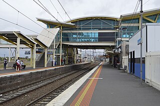
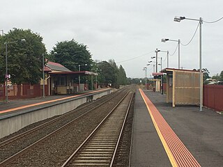
General information | |||||||||||||||
Location | 122 Queen Street, [1] Warragul, Victoria 3820 Shire of Baw Baw Australia | ||||||||||||||
Coordinates | 38°09′53″S145°55′56″E / 38.1647°S 145.9323°E | ||||||||||||||
Owned by | VicTrack | ||||||||||||||
Operated by | V/Line | ||||||||||||||
Line(s) | Gippsland | ||||||||||||||
Distance | 99.67 kilometres from Southern Cross | ||||||||||||||
Platforms | 2 (1 island) | ||||||||||||||
Tracks | 5 | ||||||||||||||
Connections | Bus | ||||||||||||||
Construction | |||||||||||||||
Structure type | At-grade | ||||||||||||||
Parking | 200 spaces | ||||||||||||||
Bicycle facilities | Available | ||||||||||||||
Accessible | Yes | ||||||||||||||
Other information | |||||||||||||||
Status | Operational, staffed | ||||||||||||||
Station code | WGL | ||||||||||||||
Fare zone | Myki Zone 6/7 overlap | ||||||||||||||
Website | Public Transport Victoria | ||||||||||||||
History | |||||||||||||||
Opened | 1 March 1878 | ||||||||||||||
Previous names | Warrigal (1878-1879) | ||||||||||||||
Services | |||||||||||||||
| |||||||||||||||
Official name | Warragul Railway Station | ||||||||||||||
Criteria | A, D | ||||||||||||||
Designated | 20 August 1982 | ||||||||||||||
Reference no. | H1598 [1] | ||||||||||||||
Location | |||||||||||||||
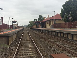
Warragul railway station is located on the Gippsland line in Victoria, Australia. It serves the town of Warragul, and it opened on 1 March 1878 as Warrigal. It was renamed Warragul on 1 May 1879. [2] [3]
It was the junction station for the branch line to Neerim South and Noojee, which closed in 1958.
The line between Pakenham and Warragul was duplicated in various stages between 1952 and 1956, and was electrified in 1954. [2] Two years earlier, in 1952, the line to Yarragon was duplicated, and in 1955, electrification was extended to Moe. [2] [3]
Starting from 15 February 1987, [4] and lasting until December 1998, [2] the station was the terminus of a number of The Met/PTC electric passenger services from Flinders Street. The line was de-electrified beyond Warragul on 28 June 1987, [5] and the overhead support structures were removed in 2005/2006, as part of the Regional Fast Rail project.
The former "A" siding was abolished in 1988, along with alterations to the points, signals and levers. [6] Also during 1988, the double line block system between Warragul and Yarragon was abolished, [7] with automatic three position signalling introduced. This introduction also resulted in the abolition of signal boxes "A" and "B", [7] both replaced by a signal panel in the station building. [2]
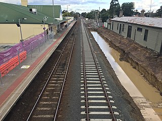
The tracks in the former yard are now used as storage for concrete sleepers, old and new signals, and rail machines. Tracks on the northern side of the station were moved slightly, to reduce the radius of curves, and allow trains to travel at higher speed.
On 28 April 2006, the signal panel within the station building was abolished. [8]
The station itself was upgraded in 2015. [9] It included a new car park and a bus interchange, a new footbridge next to the Alfred Street overpass and a new road underpass at Normanby Place, located at the eastern end of the station. [9]
Warragul has one island platform with two faces. It is serviced by V/Line Traralgon and Bairnsdale line services. [10] [11]
Platform 1:
Platform 2:
Warragul Bus Lines operates eight routes via Warragul station, under contract to Public Transport Victoria:
The Shire of Baw Baw is a local government area in Victoria, Australia, in the eastern part of the state. It covers an area of 4,028 square kilometres (1,555 sq mi) and in June 2018 had a population of 52,015.
Oakleigh railway station is a commuter railway station in the suburb of Oakleigh in the south-east of Melbourne, Victoria, Australia. The station opened in 1877 as the up end of the Gippsland line, with the station being electrified in 1922. The station consists of two sides that are connected to each other via the adjacent roads, and both platforms are connected to each other via a pedestrian subway.
Dandenong railway station is the junction for the Pakenham and Cranbourne lines in Victoria, Australia. It serves the south-eastern Melbourne suburb of the same name, and opened on 8 October 1877.
Berwick railway station is located on the Pakenham line in Victoria, Australia. It serves the south-eastern Melbourne suburb of Berwick, and it opened on 8 October 1877.
Pakenham railway station is the terminus of the suburban electrified Pakenham line in Victoria, Australia. It serves the south-eastern Melbourne suburb of Pakenham, and it opened on 8 October 1877.
The Gippsland V/Line rail service is a passenger service operated by V/Line in Victoria, Australia between Melbourne and the Gippsland region including the regional cities of Moe, Morwell, Traralgon, Sale and Bairnsdale. It operates along the Gippsland railway line.
Nar Nar Goon railway station is located on the Gippsland line in Victoria, Australia. It serves the town of Nar Nar Goon, and it opened on 1 April 1881.
Tynong railway station is located on the Gippsland line in Victoria, Australia. It serves the town of Tynong, and it opened on 12 February 1880.
Garfield railway station is located on the Gippsland line in Victoria, Australia. It serves the town of Garfield, and it opened on 17 December 1884 as Cannibal Creek Siding. It was renamed Garfield on 28 March 1887.
Bunyip railway station is located on the Gippsland line in Victoria, Australia. It serves the town of Bunyip, and opened on 8 October 1877.
Longwarry railway station is located on the Gippsland line in Victoria, Australia. It serves the town of Longwarry, and opened on 1 July 1881.
Drouin railway station is located in Drouin, Victoria along the Gippsland railway line. It opened on 1 March 1878.
Yarragon railway station is located on the Gippsland line in Victoria, Australia. It serves the town of Yarragon, and it opened on 1 August 1878 as Waterloo. It was renamed Yarragon on 17 December 1883.
Trafalgar railway station is located on the Gippsland line in Victoria, Australia. It serves the town of Trafalgar, and it opened on 1 August 1878. On 5 May 1884, it was renamed Narracan, and was renamed Trafalgar on 2 June of that year.
Moe railway station is located on the Gippsland line in Victoria, Australia. It serves the town of Moe, and it opened on 1 March 1878.
Morwell railway station is located on the Gippsland line in Victoria, Australia. It serves the town of Morwell, and it opened on 1 June 1877.
Yarragon is a town in the Shire of Baw Baw in the West Gippsland region of Victoria, Australia. The town lies on the Princes Highway and the main Gippsland Railway line approximately halfway between the major towns of Warragul and Moe. Hills of the Strzelecki Ranges rise over 500 metres (1,600 ft) immediately to the south of the town, providing a spectacular backdrop, while the Moe River and the lowlands lie to the north and east. Mount Worth at 515 m (1,690 ft) above sea level is the highest near peak to the south in the Mount Worth State Park 16 kilometres (9.9 mi) SSW of Yarragon. Mount Baw Baw at 1,563 m (5,128 ft) in the Baw Baw Ranges as part of the Great Dividing Range to the north is approximately 85 kilometres (53 mi) NNE of Yarragon. The township sits at approximately 88 metres (289 ft) above sea level. At the 2006 census, Yarragon had a population of 1131.
Traralgon railway station is located on the Gippsland line in Victoria, Australia. It serves the city of Traralgon, and it opened on 1 June 1877.
The Gippsland line is a railway line serving the Latrobe Valley and Gippsland regions of Victoria, Australia. It runs east from the state capital Melbourne through the cities of Moe, Morwell, Traralgon, Sale and terminating at Bairnsdale.
Sale railway station is located on the Gippsland line in Victoria, Australia. It serves the town of Sale, and it opened on 4 December 1983.