Leongatha railway station

Last updated

Leongatha
South Gippsland Railway station
South-Gippsland-Railway-Leongatha.jpg
Former South Australian Railways Redhen railcar No. 402 at Leongatha station, December 2008
General information
Location133.9 km (83.2 mi) from Flinders Street
Line(s) South Gippsland Railway
Platforms1
Tracks6 (mainline + 5 roads)
Other information
StatusClosed 16 January 2016
History
Opened17 November 1891;132 years ago (1891-11-17)
1994;30 years ago (1994) (re-opened)
Closed24 July 1993;30 years ago (1993-07-24)
Services
Preceding station Disused railways Following station
 Tourist service 
Korumburra   South Gippsland Tourist Railway line Terminus
 Closed lines 
Ruby   South Gippsland line  Koonwarra
  List of closed railway stations in Victoria  

Leongatha is a railway station in the town of Leongatha, Victoria on the former South Gippsland railway line in South Gippsland, Victoria, Australia.

Contents

The station opened in 1891 as a terminus, the line being extended to Welshpool the next year. [1] Initially the station was planned to be named "Koorooman", later being changed to "Leongatha" at time of construction. [2] For a number of years after the ending of regular V/Line passenger operations on the line east of Cranbourne in 1993, [3] the station was the terminus of the former South Gippsland Tourist Railway, but its operations ceased in January 2016.

The track south of Leongatha has been dismantled and turned into the Great Southern Rail Trail. The station precinct includes a well preserved red brick station building, goods shed, water tower and footbridge. The goods shed has since been demolished with a view of converting the unused railway reservation for a shopping plaza, which has not yet eventuated.

The track east of Leongatha Station ended at the rear of a petrol station, approx 500 metres away. The home signal for trains approaching Leongatha from Koonwarra remained, but because there was no rail for any significant distance from the signal, it was decommissioned. From the end of the rails, the reservation is a crushed rock pathway mainly used by bicycles and pedestrians.

The South Gippsland Shire Council had successfully attained a 18 year lease of the 35 km railway corridor from Leongatha to Nyora. Its intention for the corridor is to remove the railway tracks and replace it with a bicycle track aimed to attract a Melbourne based tourism market.

Regardless of community representations to the Victorian state government seeking the return of railway services, the council has, since January 2020 commenced works to remove the railway infrastructure from the railway reservation from Leongatha station to Nyora station.

Current status

The reopening the South Gippsland railway line as far as Leongatha is continuing to feature as a prominent issue for the region. [4]

The line was first closed along with numerous other regional Victorian railways by the Lonie Report in 1981. The Transport Users Group was successful campaigning to have passenger rail services reinstated to Leongatha on 9 December 1984. [5]

The line would again be closed first to Barry Beach and Yarram in 1992, and then to Leongatha in July 1993. [6]

The promise in 1999 to revive the railway line for freight and passenger services, by the Steve Bracks-led Victorian state Labor government, was abandoned in 2008 by his successor John Brumby. A community campaign involving the South and West Gippsland Transport Group is continuing to work collaboratively with key stakeholders and governments to have rail services reinstated, and generally improve transport accessibility in the region. The South and West Gippsland Transport Group, a public transport and rail lobby group, established in April 2011, is closely associated with the South Gippsland Shire Council and other local governments. It has continued to campaign for an integrated transport plan in the region, which includes rail at the forefront of the proposal. [7]

A South Gippsland Shire Council Priority Projects documents released in June 2013 acknowledged that the return of rail as a major community priority where funding and support are sought from all forms of level government. [8] In early 2014, a report into the extensions of the Melbourne metropolitan rail system identified the population growth corridor from Cranbourne to Koo-Wee-Rup along the disused Leongatha line as a key planning priority. [9]

V/Line bus terminus

Leongatha Railway Station is used as a terminus for the V/Line Road Coach service, and as a stop on the Coach route to Yarram. The railway station toilet facilities have recently become available to V/Line bus passengers. As of 2017, these toilet facilities have been closed, although a newer toilet was provided at the stop in recent years.

Location

Leongatha Railway Station is located on Long street, Leongatha. Long Street is accessible from the Strzelecki Highway and Nerrena Road, just off the South Gippsland Highway.

Trains from Leongatha

The disused station in March 2022 Leongatha station viewed from rail trail -- March 2022.jpg
The disused station in March 2022

Since the closure of the South Gippsland Tourist Railway, no train services operate from Leongatha Station.

V/Line coach services

To compensate for the government not re-opening the railway to Leongatha for passenger services, a new bus timetable provided for additional services from Spencer Street Station (now Southern Cross station) in Melbourne to Leongatha and Yarram.

The current timetable provides for eight coach services daily, four of which continue through to the former railway terminus at Yarram. Weekend timetables provide for four services on each of Saturday and Sunday.

The increased timetable had proven popular, with some services needing two coaches to cope with the traffic.

Related Research Articles

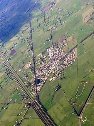
Clyde is a suburb of Melbourne, Victoria, Australia, 48 km south-east of Melbourne's Central Business District, located within the City of Casey local government area. Clyde recorded a population of 11,177 at the 2021 census.

<span class="mw-page-title-main">Tooradin, Victoria</span> Town in Victoria, Australia

Tooradin is a town in Victoria, Australia, 57 km south east of Melbourne's Central Business District, located within the City of Casey and the Shire of Cardinia local government areas. Tooradin recorded a population of 1,722 at the 2021 census.
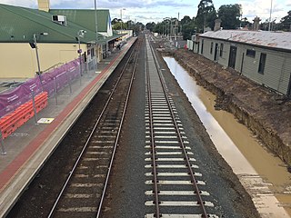
<span class="mw-page-title-main">Cranbourne railway station</span> Railway station in Melbourne, Australia

Cranbourne railway station is the terminus of the suburban electrified Cranbourne line in Victoria, Australia. It serves the south-eastern Melbourne suburb of Cranbourne, and opened on 1 October 1888.

<span class="mw-page-title-main">Cranbourne line</span> Passenger rail service in metropolitan Melbourne, Victoria, Australia

The Cranbourne line is a commuter railway line in the city of Melbourne, Victoria, Australia. Operated by Metro Trains Melbourne, it is the city's second longest metropolitan railway line at 44 kilometres (27 mi). The line runs from Flinders Street station in central Melbourne to Cranbourne station in the south-east, serving 24 stations via the City Loop, South Yarra, Caulfield, Oakleigh, and Dandenong. The line operates for approximately 20 hours a day with 24 hour service available on Friday and Saturday nights. During peak hour, headways of up to 5 to 15 minutes are operated with services every 15–20 minutes during off-peak hours. Trains on the Cranbourne line run with a seven-car formation operated by High Capacity Metro Trains.

<span class="mw-page-title-main">Leongatha</span> Town in Victoria, Australia

Leongatha is a town in the foothills of the Strzelecki Ranges, South Gippsland Shire, Victoria, Australia, located 135 kilometres (84 mi) south-east of Melbourne. At the 2021 census, Leongatha had a population of 5,869.

<span class="mw-page-title-main">Traralgon railway station</span> Railway station in Victoria, Australia

Traralgon railway station is located on the Gippsland line in Victoria, Australia. It serves the city of Traralgon, and it opened on 1 June 1877.

<span class="mw-page-title-main">Lang Lang, Victoria</span> Town in Victoria, Australia

Lang Lang is a town in Victoria, Australia, 73 km south-east of Melbourne's Central Business District, located within the Shires of Bass Coast, Cardinia and South Gippsland local government areas. Lang Lang recorded a population of 2,556 at the 2021 census.

<span class="mw-page-title-main">Great Southern Rail Trail</span>

The Great Southern Rail Trail is a 109-kilometre rail trail from Nyora to Welshpool in South Gippsland, Victoria, Australia. Sections of the trail are flat or gently undulating trail through lush dairy farmland, areas of remnant bush and lowland scrub. There is a big climb on the section between Loch and Leongatha. The section between Fish Creek and Foster climbs past Mount Hoddle and goes through dense forest with occasional magnificent views of Wilsons Promontory and Corner Inlet.

The South Gippsland railway line is a partially closed railway line in Victoria, Australia. It was first opened in 1892, branching from the Orbost line at Dandenong, and extending to Port Albert. Much of it remained open until December 1994. Today, only the section between Dandenong and Cranbourne remains open for use. The section of the line from Nyora to Leongatha was used by the South Gippsland Tourist Railway until it ceased operations in 2016. The section from Nyora to Welshpool, with extension trail to Port Welshpool and a portion of the former line at Koo Wee Rup, have been converted into the Great Southern Rail Trail.

The South Gippsland Railway was a tourist railway located in South Gippsland, Victoria, Australia. It controlled a section of the former South Gippsland railway line between Nyora and Leongatha, and operated services from Leongatha to Nyora, via Korumburra, the journey taking about 65 minutes.

Clyde was a railway station on the South Gippsland line in South Gippsland, Victoria, Australia, the station operated until the closure of the line between Cranbourne Station and Leongatha Station in 1993. All that remains of this station now is the platform mound, however the track is still in reasonable condition.

Koo Wee Rup was a railway station on the South Gippsland line in South Gippsland, Victoria, Australia. The station operated until the closure of the line between Cranbourne Station and Leongatha Station in July 1993. The station remains partly intact with the platform and goods shed intact, however the track one kilometre on each side of the station platform has been dismantled, and replaced by a concrete pathway for bicycles and recreational use. Koo Wee Rup was also the junction of the branch line to Strzelecki. The establishment of the pathway has effectively removed any likelihood that the railway will be rehabilitated. It can also be seen as being the start of a rail trail on the railway reserve, stretching back to Cranbourne, which will block future rail transport options for people in Cranbourne East, Clyde, and surrounding areas.

Lang Lang was a railway station on the South Gippsland line in South Gippsland, Victoria, Australia. The station operated until the closure of the line between Cranbourne Station and Leongatha Station in 1993. This station remains partially intact with its platform and signals still in reasonable condition, the track along this section is still in reasonable condition.

Nyora is a railway station on the former South Gippsland line in South Gippsland, Victoria, Australia.

<span class="mw-page-title-main">Loch railway station</span> Railway station in Victoria, Australia

Loch is a railway station on the former South Gippsland line in South Gippsland, Victoria, Australia. The station was then part of the South Gippsland Tourist railway, after passenger operations on the line ceased after Cranbourne station in 1993, until 2016, when the railway shut down. It is located on the Great Southern Rail Trail.

<span class="mw-page-title-main">Korumburra railway station</span> Former railway station in Victoria, Australia

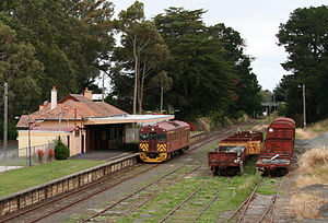
Korumburra is a heritage listed railway station on the former South Gippsland line in South Gippsland, Victoria, Australia. Passenger operations on the line ceased beyond Cranbourne station in July 1993. The station was part of the South Gippsland tourist railway between 1994 and 2015 but is no longer in use.

Australian Glass Manufacturers Siding, which is also known as Koala Siding, was a railway siding on the South Gippsland line in South Gippsland, Victoria, Australia.

<span class="mw-page-title-main">Nyora</span> Town in Victoria, Australia

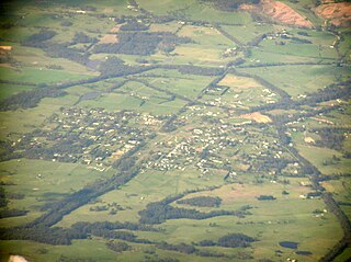
Nyora is a town in South Gippsland, Victoria, Australia, approximately 84 kilometres (52 mi) south-east of Melbourne's Central Business District, located within the Shires of Baw Baw, Cardinia and South Gippsland local government areas. Nyora recorded a population of 1,644 at the 2021 census.

<span class="mw-page-title-main">Loch, Victoria</span> Town in Victoria, Australia

Loch is a town in the South Gippsland region of Victoria, Australia which was established in 1876. The town was named in honour of the Governor of Victoria, Henry Loch.

<span class="mw-page-title-main">Koo Wee Rup</span> Town in Victoria, Australia

Koo Wee Rup is a town and satellite suburb in Victoria, Australia, 63 km south-east of Melbourne's Central Business District, located within the Shire of Cardinia local government area. Built on former marshland now converted to market gardens, Koo Wee Rup recorded a population of 4,047 at the 2021 census.

References

  1. Sid Brown (March 1990). "Tracks Across the State". Newsrail. Australian Railway Historical Society (Victorian Division). pp. 71–76.
  2. Plan & Section Book, Dandenong - Port Albert (Whitelaw - Toora Section), - Railway Department of Melbourne, c. Oct 1888
  3. Chris Banger (March 1997). "Rail Passenger Service Withdrawals Since 1960". Newsrail. Australian Railway Historical Society (Victorian Division). pp. 77–82.
  4. "Regional Network Development Plan feedback hears calls for better country public transport, reopened passenger lines – ABC News (Australian Broadcasting Corporation)". Abc.net.au. 13 July 2015. Retrieved 19 August 2015.
  5. "PTUA Newsletter" (PDF). ptua.org.au. January 1985. Retrieved 19 August 2015.
  6. Archived 27 February 2015 at the Wayback Machine
  7. Archived 27 February 2015 at the Wayback Machine
  8. "Priority Projects for Support" (PDF). Southgippsland.vic.gov.au. June 2013. Retrieved 19 August 2015.[ permanent dead link ]
  9. "Appendix 2–10 : Information Provided to Aurecon" (PDF). Mpa.vic.gov.au. Archived from the original (PDF) on 23 March 2015. Retrieved 19 August 2015.

38°28′38″S145°56′52″E / 38.47722°S 145.94778°E / -38.47722; 145.94778