Great Southern Rail Trail | |
---|---|
Length | 109 km |
Location | Melbourne, Victoria, Australia |
Established | 2015 |
Difficulty | Easy to medium |
Hazards | Some crossings of major highways |
Surface | Compacted gravel |
Hills | Multiple gentle hills |
Water | Available in most towns |
Train(s) | No regular passenger service |
Bus | Available at Leongatha |
The Great Southern Rail Trail is a 109-kilometre rail trail from Nyora to Welshpool in South Gippsland, Victoria, Australia. [1] Sections of the trail are flat or gently undulating trail through lush dairy farmland, areas of remnant bush and lowland scrub. There is a big climb on the section between Loch and Leongatha. The section between Fish Creek and Foster climbs past Mount Hoddle and goes through dense forest with occasional magnificent views of Wilsons Promontory and Corner Inlet. [2]
The trail is well maintained with a surface of compacted gravel. Koalas, Wombats, wallabies and Echidnas can often be seen from the trail particularly in the early mornings and evenings.
The 10km Toora to Welshpool section was opened on 7 February 2015. The section from Koonwarra to Minns road was opened in March 2016, incorporating what had been three very dilapidated wooden trestle bridges and replacing a three-kilometre diversion to the nearby South Gippsland Highway. That made the trail continuous from Leongatha to Welshpool, and users can link to the 6km pathway to Port Welshpool and its picturesque Long Jetty.
Two trestle bridges north of Loch were surfaced in late 2022. That completed the trail between Nyora and Loch, bringing the total trail length from Nyora to Welshpool to 107km.
The trail is being progressively extended and is planned to eventually reach Port Albert and Yarram. [3]
The original South Gippsland line opened in 1892, joining Dandenong to Port Albert, with branch line to Woodside, Strzelecki, Outtrim and Wonthaggi. The railway was important for the settlement and development of the area, particularly providing transport for forestry and dairy products to Melbourne.
The line was closed to all rail traffic on 30 June 1992, a century after opening, when rail freight services to the Esso Mobil Barry Beach Marine Terminal, situated on Corner Inlet, ceased operation. Almost two weeks prior, on 17 June 1992, superphosphate rail freight services along the line to Buffalo ceased, which was the last 'mixed goods service' in the region and a distinctive feature of the line during its existence.
The line beyond Leongatha, to Yarram and Barry Beach, was dismantled in stages until 14 December 1994, when a V/Line 'rail recovery' train removed the last of the tracks, which were subsequently reused for the Melbourne to Adelaide railway line gauge standardisation project throughout 1995. The same day also saw the closure of the South Gippsland railway line from Nyora to Leongatha, but, two weeks later, that section of the line was reopened by the South Gippsland Railway tourist railway, which operated heritage rail services until December 2015.
The establishment of the South Gippsland Railway, and the electrification of the Cranbourne line in March 1995, thwarted the original plan by the Victorian state government to dismantle the entire line as far back as Cranbourne. The South Gippsland Railway formally ceased operations on 16 January 2016. [4]
Construction of sections of the trail from Nyora to Leongatha are in progress in 2021. [5]
The following sections were open as at November 2021:
In late 2022 two high trestle bridges north of Loch (over Allsop Creek and the Bass River) were surfaced which completed the trail between Nyora and Loch.
The section from Korumburra to Leongatha was completed in April 2022. [6]
Leongatha is located in the foothills of South Gippsland's Strzelecki Ranges with a population around 5,000. [7] The trail passes through wide-open spaces of lush dairy country before entering teatree and eucalypt bushland near Koonwarra.
Incorporating a new section of trail covering three old wooden trestle bridges. The path winds its way around hills and over river flats with wonderful views of the local area.
This is a fairly rough section of the track, and there is an old timber bridge alongside the new bridge over the Tarwin River near Meeniyan. [8]
This section of the trail has a fine gravel surface and passes through bushland, swamp scrub and lowland forest. There is abundant local wildlife; kangaroos, wallabies and bird life thrive in this area. At the foothills of the Hoddle Range, there are steeper parts of the trail and a number of cuttings and embankments. [8]
The quirky town of Fish Creek has a strong arts scene and plenty of options to eat and restock supplies. There is a climb from Fish Creek to Hoddle Summit where there are views over Corner Inlet and Wilsons Promontory from the peak.
Foster is a small regional town but caters well for visitors and there are plenty of accommodation options. [9]
A trail connects Welshpool with Port Welshpool on the coast. The trail is initially an off-road bike path, then joins a quiet unsealed road which follows the alignment of the former horse-drawn Port Welshpool Tramway. Port Welshpool has views of Corner Inlet, Snake Island and the northern section of Wilsons Promontory National Park, and the Port Welshpool Long Jetty.
Funding for the extension of a section of the trail from Welshpool to Alberton was announced on 7 July 2021. [10]
Tooradin is a town in Victoria, Australia, 57 km south east of Melbourne's Central Business District, located within the City of Casey and the Shire of Cardinia local government areas. Tooradin recorded a population of 1,722 at the 2021 census.
The South Gippsland Highway is a partially divided highway in Victoria, Australia which connects the city of Melbourne with the South Gippsland region of Victoria, ending in the town of Sale. The highway begins at Lonsdale Street, Dandenong. At the Greens Road intersection, it adopts Metropolitan Route 12 until Pound Road, then continues until the South Gippsland Freeway / Western Port Highway interchange where it becomes the M420. The M420 continues through Cranbourne and Koo Wee Rup until the Bass Highway turnoff, at which point the road is then designated A440 onwards to Sale. From the Bass Highway junction, the highway is undivided. The South Gippsland Highway is the gateway from Melbourne to many attractions including Wilsons Promontory and Phillip Island as well as being an important road for farmers in Gippsland.
Korumburra is a town in the Australian state of Victoria. It is located on the South Gippsland Highway, 120 kilometres (75 mi) south-east of Melbourne, in the South Gippsland Shire local government area. At the 2016 census Korumburra had an urban population of 3,639.
Leongatha is a town in the foothills of the Strzelecki Ranges, South Gippsland Shire, Victoria, Australia, located 135 kilometres (84 mi) south-east of Melbourne. At the 2021 census, Leongatha had a population of 5,869.
Toora is a small farming town in Victoria, Australia whose main industry is dairy farming. It is located at the top of Corner Inlet opposite Wilsons Promontory National Park. In the 2016 census the population was 681.
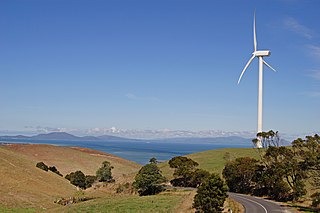
Foster is a dairying and grazing town 174 kilometres (108 mi) south-east of Melbourne on the South Gippsland Highway in Victoria, Australia. At the 2016 census Foster had an urban population of 1,164. It is about 20 kilometres (12 mi) north of the Gippsland coastline which includes Shallow Inlet, Corner Inlet, Waratah Bay, Yanakie and Wilsons Promontory.
The Gippsland line is a railway line serving the Latrobe Valley and Gippsland regions of Victoria, Australia. It runs east from the state capital Melbourne through the cities of Moe, Morwell, Traralgon, Sale and terminating at Bairnsdale.
The South Gippsland railway line is a partially closed railway line in Victoria, Australia. It was first opened in 1892, branching from the Orbost line at Dandenong, and extending to Port Albert. Much of it remained open until December 1994. Today, only the section between Dandenong and Cranbourne remains open for use. The section of the line from Nyora to Leongatha was used by the South Gippsland Tourist Railway until it ceased operations in 2016. The section from Nyora to Welshpool, with extension trail to Port Welshpool and a portion of the former line at Koo Wee Rup, have been converted into the Great Southern Rail Trail.
The South Gippsland Railway was a tourist railway located in South Gippsland, Victoria, Australia. It controlled a section of the former South Gippsland railway line between Nyora and Leongatha, and operated services from Leongatha to Nyora, via Korumburra, the journey taking about 65 minutes.
Nyora is a railway station on the former South Gippsland line in South Gippsland, Victoria, Australia.
Loch is a railway station on the former South Gippsland line in South Gippsland, Victoria, Australia. The station was then part of the South Gippsland Tourist railway, after passenger operations on the line ceased after Cranbourne station in 1993, until 2016, when the railway shut down. It is located on the Great Southern Rail Trail.
Korumburra is a heritage listed railway station on the former South Gippsland line in South Gippsland, Victoria, Australia. Passenger operations on the line ceased beyond Cranbourne station in July 1993. The station was part of the South Gippsland tourist railway between 1994 and 2015 but is no longer in use.
Leongatha is a railway station in the town of Leongatha, Victoria on the former South Gippsland railway line in South Gippsland, Victoria, Australia.
Australian Glass Manufacturers Siding, which is also known as Koala Siding, was a railway siding on the South Gippsland line in South Gippsland, Victoria, Australia.
Welshpool was a railway station on the South Gippsland line in South Gippsland, Victoria. The station formerly served the small town of Welshpool. The station was opened during the 1890s and operated until the 1980s. The site of the station contains a preserved platform and the base of its crane. The station no longer contains the tiny building that was donated to Loch station. Between 26 June 1905 and 1 January 1941, a horse-drawn 762 mm narrow gauge branch line, just under 5 kilometres (3.1 mi) long, ran from Welshpool station to Welshpool Jetty. Near the former station is Welshpool Hospital.
The East Gippsland Rail Trail is a rail trail located in East Gippsland in Victoria, Australia. The trail is a popular cycling route, beginning in Bairnsdale and extending to Orbost, following the route of the former Gippsland railway line. The Gippsland railway line was opened in 1916 to serve the agricultural and timber industry, and required numerous substantial bridges because of the nature of the terrain. Due to the decline in traffic and heavy operating costs, the line was finally closed in August 1987 and the track infrastructure removed in 1994. The shared trail is also available for walkers and recreational horseriding, however motorised vehicles are prohibited.
Meeniyan is a small country town on the South Gippsland Highway between Leongatha and Foster in Australia. As of 2016 it has a population of 771.
The electoral district of Gippsland South is a Lower House electoral district of the Victorian Parliament. It is located within the Eastern Victoria Region of the Legislative Council.
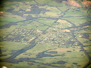
Nyora is a town in South Gippsland, Victoria, Australia, approximately 84 kilometres (52 mi) south-east of Melbourne's Central Business District, located within the Shires of Baw Baw, Cardinia and South Gippsland local government areas. Nyora recorded a population of 1,644 at the 2021 census.
Loch is a town in the South Gippsland region of Victoria, Australia which was established in 1876. The town was named in honour of the Governor of Victoria, Henry Loch.