The Waranga Dam is a major earthfill embankment dam with an uncontrolled spillway located approximately 150 kilometres (93 mi) north of Melbourne in the North Central region of the Australian state of Victoria. The impounded off-stream reservoir is Waranga Basin and forms part of the Goulburn River irrigation system, irrigating an area of 626 square kilometres (242 sq mi). The dam and reservoir are located in Shire of Campaspe near the City of Greater Shepparton and is located 8 kilometres (5.0 mi) northeast of Rushworth, 12 kilometres (7.5 mi) southwest of Tatura, and near Murchison. When full, the reservoir covers an area of 58.5 square kilometres (22.6 sq mi).

Murchison is a small riverside rural village located on the Goulburn River in Victoria, Australia. Murchison is located 167 kilometres from Melbourne and is just to the west of the Goulburn Valley Highway between Shepparton and Nagambie. The surrounding countryside contains orchards, vineyards and dairy farms and also HM Prison Dhurringile. At the 2016 census, Murchison had a population of 925.

A rail trail is a shared-use path on railway right of way. Rail trails are typically constructed after a railway has been abandoned and the track has been removed, but may also share the right of way with active railways, light rail, or streetcars, or with disused track. As shared-use paths, rail trails are primarily for non-motorized traffic including pedestrians, bicycles, horseback riders, skaters, and cross-country skiers, although snowmobiles and ATVs may be allowed. The characteristics of abandoned railways—gentle grades, well-engineered rights of way and structures, and passage through historical areas—lend themselves to rail trails and account for their popularity. Many rail trails are long-distance trails, while some shorter rail trails are known as greenways or linear parks.

Wubin is located in the northern Wheatbelt region of Western Australia, 272 kilometres (169 mi) north-northeast of Perth and 21 kilometres (13 mi) north of Dalwallinu.

The Goulburn Valley Football Netball League is an Australian rules football and netball competition based in the Goulburn Valley region of Victoria, Australia. It is a member of the Victorian Country Football League and has won the Victorian Country Football Championships in 2003 and 2005.
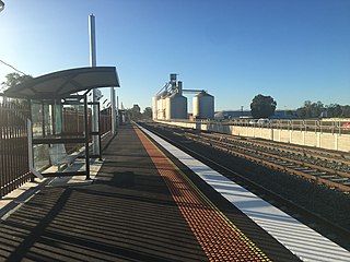
Murchison East railway station is located on the Tocumwal line in Victoria, Australia. It serves the town of Murchison East, and it opened on 1 September 1890 as Murchison.
The Tocumwal railway line is a 1,600 mm gauge railway line in Victoria, Australia. The line runs between the border town of Tocumwal in New South Wales to Southern Cross, Melbourne. The line is utilised by various passenger and freight trains serving the northern suburbs of Melbourne and northern regions of Victoria.

The Shire of Murchison covers a large area of the Murchison sub-region of the central part of Western Australia, 300 kilometres (186 mi) northeast of Geraldton. The shire and the older 'Murchison' region and goldfield are now part of the designated Mid West region. It is Australia's second least populated local government area and the only one without a town.
Boolardy Station is a remote former sheep and cattle station in the Mid West (Murchison) region of Western Australia, about 194 km (121 mi) north-north-east of Pindar and 200 km (120 mi) west-south-west of Meekatharra. It is within the Shire of Murchison and situated on pastoral lease no. 3114/406. The area of the lease is 3,467.48 square kilometres (1,338.80 sq mi).

The Shire of Waranga was a local government area about 165 kilometres (103 mi) north of Melbourne, the state capital of Victoria, Australia. The shire covered an area of 1,644.19 square kilometres (634.8 sq mi), and existed from 1863 until 1994.
The Mansfield railway line is a closed 121-kilometre (75 mi) branch railway line situated in the Hume region of Victoria, Australia. Constructed by the Victorian Railways, it branches from the Seymour line at Tallarook station, and runs east from the town of Tallarook to Mansfield. The line was primarily built to provide a general goods and passenger service to townships in the area.
Oakajee Port is a proposed deep water port to be built in the Mid West region of Western Australia, 24 kilometres (15 mi) north of Geraldton, to service the region's growing iron ore industry.

The Colbinabbin railway line is a closed 42-kilometre (26 mi) branch railway line situated in both the Hume and Loddon Mallee regions of Victoria, Australia. Constructed by the Victorian Railways, it branches from the Shepparton line at Murchison East station, and runs west from the town of Murchison East to Colbinabbin. The line was primarily built to serve the grain industries as well as providing a general goods and passenger service to townships in the area.

A long-distance trail is a longer recreational trail mainly through rural areas used for hiking, backpacking, cycling, horse riding or cross-country skiing. They exist on all continents except Antarctica.
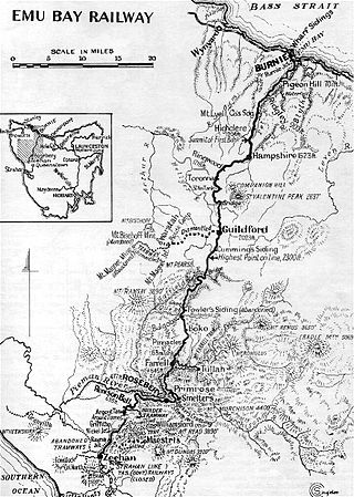
The Emu Bay Railway was a Tasmania, Australian railway company. The railway was significant during full operation, in that it linked the Tasmanian Government Railways system at Burnie with that at Zeehan that further linked to the Mount Lyell railway allowing connection through to Queenstown.

The Nanango railway line was a narrow-gauge branch railway located in Queensland, Australia. On 31 October 1882, parliament approved the construction of a branch line from Theebine west to Kilkivan after gold and copper were discovered in this region of Queensland, Australia. The section was opened in two stages – to Dickabram on 1 January 1886 after two crossings of the Mary River and to Kilkivan on 6 December 1886.
The Jack Hills mine is a haematite iron ore mine located 400 kilometres (250 mi) northeast of Geraldton and 165 kilometres (103 mi) northwest of Cue in the Mid West region of Western Australia. Murchison Metals began mining operations at Jack Hills on 21 September 2006, with a projected mine life of five years. The first shipment of ore was made in February 2007. Ore was trucked by road to the port of Geraldton for export. Mining was suspended in November 2012 and the project was placed on care and maintenance in June 2013.

The Rushworth Chronicle and Goulburn Advertiserwas an Australian newspaper that was published between 1886 and 1977.

Humphery Railway Bridge is a heritage-listed railway bridge on the Mungar to Monto railway line at Humphery, North Burnett Region, Queensland, Australia. It was designed by William Pagan and built in 1913. It was added to the Queensland Heritage Register on 21 October 1992.
The Girgarre railway line is a closed 23-kilometre (14 mi) branch railway line situated in the Loddon Mallee region of Victoria, Australia. Constructed by the Victorian Railways, it branches from the Colbinabbin line at Rushworth station, and runs north from the town of Rushworth to Girgarre. The line was primarily built to serve the livestock and other farm industries as well as providing a general goods and passenger service to townships in the area.
