
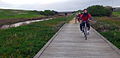
The Port Fairy - Warrnambool Rail Trail is a 37.5 kilometre rail trail in southwestern Victoria, Australia. The official opening of the trail took place on 31 May 2012 at the Koroit Railway station building. [1]
The Port Fairy - Warrnambool Rail Trail is a 37.5 kilometre rail trail in southwestern Victoria, Australia. The official opening of the trail took place on 31 May 2012 at the Koroit Railway station building. [1]
The trail begins in Port Fairy, running north then east through Koroit where it turns back southeast to Warrnambool. About two thirds is within Moyne Shire and one third within Warrnambool City. The overall construction cost of the project was approximately $2.2 million. [2]
The trail from Port Fairy to Illowa follows the path of a former branch line which ran from Port Fairy to Warrnambool and connected with the Serviceton railway line, via Hamilton. This branch line was commissioned in 1884, completed in 1890. It served primarily to connect the ports of Warrnambool and Port Fairy with destinations inland. With declining port usage, the line closed in 1977. [3]
The trail from Illowa to Warrnambool is not on the former rail track alignment, as that section of the rail reservation has been utilised for a realignment of the Princes Highway. Instead, from Lane's Lane to Millers Lane, the trail follows the old alignment of the Princess Highway (now called Illowa Road) for several kilometres on a dedicated bicycle lane beside the roadway. The bicycle lane has been fenced off to provide greater safety.
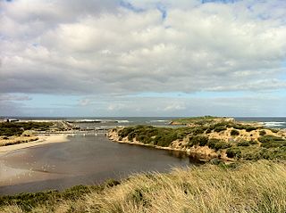
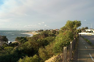
From the end of Millers Lane, the trail continues south off-road across Kelly's Swamp, then east parallel to the coast to Levy's Point. From there, the trail largely follows the cutting of the Merri River virtually all the way to the end of the trail at the Warrnambool Breakwater. [3]
The rail trail is partly paved for the sections which parallel the old alignment of the Princess Highway along with bitumen in town areas. The remaining sections are not sealed and use Packed limestone, and quartz gravel which may be rough in sections. the rail trail is accessible on hybrid, gravel, or mountain bikes. After prolonged and very heavy rain, the section of the trail at the Merri River and Kellys Swamp maybe impassable for short periods of time [4] .


Warrnambool is a city on the south-western coast of Victoria, Australia. At the 2021 census, Warrnambool had a population of 35,743. Situated on the Princes Highway, Warrnambool (Allansford) marks the western end of the Great Ocean Road and the southern end of the Hopkins Highway.

The Capital City Trail is a shared use path in Melbourne, Victoria, Australia, which circles the city centre and some inner eastern and northern suburbs. It is 29km in length, and mostly consists of sections of other trails, such as the Merri Creek Trail, Main Yarra Trail, Moonee Ponds Creek Trail and Inner Circle Rail Trail.

Koroit is a small rural town in western Victoria, Australia a few kilometres north of the Princes Highway, 18 kilometres (11 mi) north-west of Warrnambool and 272 kilometres (169 mi) west of Melbourne. It is in the Shire of Moyne local government area located amidst rolling green pastures on the north rim of Tower Hill. At the 2016 census, Koroit had a population of 2,055. The town borrows its name from the Koroitch Gundidj people who occupied the area prior to European colonisation.
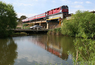
The Warrnambool line is a long-distance regional rail service in Victoria, Australia. Operated by V/Line, it is the state's fourth longest railway line at 267.3 kilometres (166.1 mi). The line runs from Southern Cross station in central Melbourne to Warrnambool station in the south-west, serving 21 stations via Wyndham Vale, Geelong, Waurn Ponds, and Colac. The line has five return services each weekday and three return services on weekends. Trains on the Warrnambool service run with three- to five-car N-class carriage sets, which are hauled by N class locomotives.
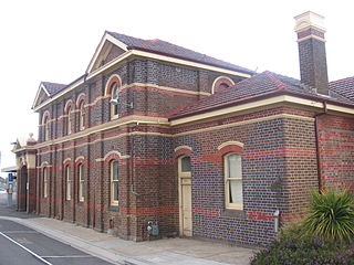
Warrnambool railway station is the terminus of the Warrnambool line in Victoria, Australia. It serves the city of Warrnambool, and it opened on 4 February 1890.

The Lilydale to Warburton Rail Trail is a walking, cycling and horse-riding track in eastern Victoria, Australia. It runs a distance of 40 km (25 mi) between Lilydale and Warburton, along the former Warburton railway line in the Yarra Valley.

The Great Southern Rail Trail is a 131-kilometre rail trail from Nyora to Yarram in South Gippsland, Victoria, Australia. Sections of the trail are flat or gently undulating trail through lush dairy farmland, areas of remnant bush and lowland scrub. There is a big climb on the section between Loch and Leongatha. The section between Fish Creek and Foster climbs past Mount Hoddle and goes through dense forest with occasional magnificent views of Wilsons Promontory and Corner Inlet.

People in the San Francisco Bay Area rely on a complex multimodal transportation infrastructure consisting of roads, bridges, highways, rail, tunnels, airports, seaports, and bike and pedestrian paths. The development, maintenance, and operation of these different modes of transportation are overseen by various agencies, including the California Department of Transportation (Caltrans), the Association of Bay Area Governments, San Francisco Municipal Transportation Agency, and the Metropolitan Transportation Commission. These and other organizations collectively manage several interstate highways and state routes, eight passenger rail networks, eight trans-bay bridges, transbay ferry service, local and transbay bus service, three international airports, and an extensive network of roads, tunnels, and bike paths.

A large metropolitan area that is surrounded by rivers and hills, Pittsburgh has an infrastructure system that has been built out over the years to include roads, tunnels, bridges, railroads, inclines, bike paths, and stairways; however, the hills and rivers still form many barriers to transportation within the city.

The Schuylkill River Trail is a multi-use trail along the banks of the Schuylkill River in southeastern Pennsylvania. Partially complete as of 2018, the trail is ultimately planned to run about 140 miles (230 km) from the river's headwaters in Schuylkill County to Fort Mifflin in Philadelphia.

The East Gippsland Rail Trail is a rail trail located in East Gippsland in Victoria, Australia. The trail is a popular cycling route, beginning in Bairnsdale and extending to Orbost, following the route of the former Gippsland railway line. The Gippsland railway line was opened in 1916 to serve the agricultural and timber industry, and required numerous substantial bridges because of the nature of the terrain. Due to the decline in traffic and heavy operating costs, the line was finally closed in August 1987 and the track infrastructure removed in 1994. The shared trail is also available for walkers and recreational horseriding, however motorised vehicles are prohibited.

The Warrnambool railway line is a railway serving the south west of Victoria, Australia. Running from the western Melbourne suburb of Newport through the cities of Geelong and Warrnambool, the line once terminated at the coastal town of Port Fairy before being truncated to Dennington. This closed section of line has been converted into the 37 km long Port Fairy to Warrnambool Rail Trail. The line continues to see both passenger and freight services today.

The Main Yarra Trail, also known as the Yarra Trail is a shared-use path for cyclists and pedestrians, which follows the Yarra River through the northeastern suburbs of Melbourne, Victoria, Australia.

Bicycle paths around Melbourne are off-road routes for use by people riding bicycles and walking have been developed over many decades. These primarily follow current or former watercourses and major roads to traverse long distances and provide facilities for both transport and recreation.

Jones Falls Trail is a hiking and bicycling trail in Baltimore, Maryland. It mostly runs along the length of the namesake Jones Falls, a major north–south stream in and north of the city that has long acted as a major transportation corridor for the city. It also incorporates the bike path encircling Druid Hill Reservoir and its namesake park. The Jones Falls Trail forms a segment of the East Coast Greenway, a partially completed network of off-road bicycling routes that runs the length of the East Coast.

Gywnns Falls Trail is a 15-mile (24 km) series of hiking and bicycling trails inside Baltimore, Maryland, named for the Gwynns Falls, whose course it follows, and the surrounding Gwynns Falls Leakin Park it passes through. The trail uses unique alignments, sidepaths on existing streets, and on-street sections. The trail consists of one 10.75-mile (17.30 km) mainline, plus a number of branches, including the Middle Branch Trail, the Hutton Trail, and the Dickeyville Trail. All of these trails carry signage designating them as the Gwynns Falls Trail; their individual names are designated on the mile markers designating their route. The entirety of the Middle Branch Trail, as well as the section of the mainline trail east of the Middle Branch Trail's northern terminus, are part of the East Coast Greenway.

The Three Creeks Trail is a 0.9-mile (1.4 km) pedestrian and bicycle trail that runs through the Willow Glen neighborhood in San Jose, California, from Los Gatos Creek by Lonus Street to the Guadalupe River. It directly connects to the northern segment of the Los Gatos Creek Trail and indirectly connects to several other trails.
The Hamilton-Koroit railway line was a branch line running south west from the Portland Main Line at Coleraine Junction near the town of Hamilton, to the town of Koroit, where it joined the Port Fairy line. Opening in 1890, the line was 84 kilometers long and entirely single track apart from at stations. Since the closure of the line in 1977, the track has been removed and the rail reserve mostly sold as well, with very little trace of railway left.
Jeremiah Wall was an Australian politician. He was an Australian Labor Party member of the Victorian Legislative Assembly from 1908 to 1911, representing the electorate of Port Fairy.
The Bay Trail is a shared use path for cyclists and pedestrians which follows the coastline of Port Phillip Bay through the south-eastern suburbs of Melbourne, Victoria, Australia.
38°17′17″S142°21′19″E / 38.28806°S 142.35528°E
| | This article about a location in Barwon South West (region) is a stub. You can help Wikipedia by expanding it. |