Melbourne tram route 58

Last updated

Route 58
Yarra Trams E-class 6083 Route 58, January 2022 1.jpg
E class tram at Flagstaff station in January 2022
Overview
System Melbourne
Operator Yarra Trams
Depot Essendon
Southbank
Vehicle Z class
B class
E class
Began service1 May 2017
Predecessors Route 8
Route 55
Route
Start West Coburg
Via Brunswick West
Parkville
North Melbourne
West Melbourne
William Street
Southbank
South Yarra
End Toorak
Length18.0 kilometres
Timetable Route 58 timetable
Map Route 58 map
  Route 57  {{{system_nav}}}  Route 59  

Melbourne tram route 58 is operated by Yarra Trams on the Melbourne tram network from West Coburg to Toorak. The 18.0 kilometre route is operated out of Essendon and Southbank depots with Z, B and E class trams.

Contents

History

Route 58 was introduced on 1 May 2017 as part of a restructure of the Yarra Trams network to facilitate the closure of Domain Interchange and the construction of Anzac railway station. It replaced route 55 in its entirety from West Coburg to Domain Interchange and the southern part of route 8 from Domain Interchange to Toorak. [1] [2] [3]

The origins of the lines traversed by route 58 lies in separate tram lines. The oldest section of track belongs to the section between Domain Interchange (near Stop 119) and Toorak Road (Stop 22), which dates back to the Brighton Road cable tram line, which opened on 11 October 1888. The section of track between Park Street, South Yarra (near Stop 123) and Chapel Street (Stop 128) was built later that year on 26 October as part of the Prahran cable tram line. The section between Chapel Street and Orrong Road (Stop 134) was built as the Toorak cable tram line, which opened on 15 February 1889. This section was extended by the Melbourne & Metropolitan Tramways Board (MMTB) to Glenferrie Road (Stop 139) on 8 May 1927. Meanwhile, the line between Collins Street (Stop 4) and Daly Street, Brunswick West (Stop 33) was constructed by the MMTB on 19 July 1925. This section was extended to West Coburg on 26 June 1927. The line between Sturt Street (Stop 118) and St Kilda Road was constructed on 27 December 1925. The line connecting Collins Street and Sturt Street finally opened on 21 December 1944. From 1 July 2017, route 58 was rerouted via Toorak Road West with the closure of Domain Road while Anzac railway station was built. [4]

During 2021, tram stop upgrades along the route were undertaken to allow the introduction of E class trams on the route, which commenced operation on 19 December 2021. [5] [6] [7] [8] These replaced D1 class trams from Malvern. [9]

Melbourne tram route 58 evolution
DatesRouteNotes
c. 1934 - 21 December 1940Russell Street - Footscray Never used as single-truck trams used on the line had no number plates
22 December 1940 - 11 May 1943Unallocated
12 May 1943 - 30 April 2017 Melbourne Showgrounds to City (Elizabeth Street)via North Melbourne, short-working of route 57, gradually fell out of use
1 May 2017 - present West Coburg to Toorak Merge of routes 8 and 55

Route map

Route 58
West Coburg - Toorak
via Brunswick West, City & South Yarra
Free tram zone covers stops 1 to 10, fare zone 1 applies from stop 11 to 45, 139 to 115
Suburb
Street
Stop
No.
West Coburg
Connections
Pascoe Vale South
Melville Road
45
BSicon exBLq.svg
BSicon uKBHFa.svg
BSicon exBLq.svg
Bell Street
Bus-logo.svg 513, 527, 903
44
BSicon uHST.svg
Brearley Parade
43
BSicon uHST.svg
Princes Terrace
42
BSicon uHST.svg
Reynard Street
Bus-logo.svg 512
41
BSicon uHST.svg
Woodlands Avenue
Brunswick West
Melville Road
40
BSicon exBLq.svg
BSicon uHST.svg
BSicon exBLq.svg
Moreland Road
Bus-logo.svg 510
39
BSicon uHST.svg
Mattingley Crescent
38
BSicon uHST.svg
Jacobs Reserve
37
BSicon uHST.svg
Albion Street
Bus-logo.svg 503
36
BSicon uHST.svg
Hope Street
Bus-logo.svg 509
35
BSicon uHST.svg
Victoria Street
Bus-logo.svg 508
34
BSicon uHST.svg
Smith Street
Bus-logo.svg 506
 
Dawson Street
33
BSicon uHST.svg
Daly Street
32
BSicon uHST.svg
Foden Street
 
Grantham Street
31
BSicon uHST.svg
Dawson Street
Bus-logo.svg 506
30
BSicon uHST.svg
Union Square Shopping Centre
29
BSicon uBHF.svg
Brunswick Road
Bus-logo.svg 504
28
BSicon exBLq.svg
BSicon uBHF.svg
BSicon exBLq.svg
Park Street
27
BSicon uACC.svg
Royal Park station
Bus-logo.svg 505
BSicon CONTgq.svg
BSicon umKRZu.svg
BSicon lvACC-.svg
BSicon CONTf@Fq.svg
Aiga railtransportation 25.svg Royal Park station
26
BSicon uACC.svg
Melbourne Zoo
25
BSicon uACC.svg
State Netball Hockey Centre
24
BSicon uACC.svg
Elliot Avenue
23
BSicon uACC.svg
Royal Park
BSicon uCONT2.svg
BSicon uv-STR.svg
BSicon udSTRc3.svg
Flemington Road
Tram 57, 59
BSicon uCONTgq.svg
BSicon uSTRc1.svg
BSicon uSTRr+4.svg
BSicon uv-STR.svg
BSicon uv-STR+4.svg
Abbotsford Street
Tram 57
19
BSicon uACC.svg
Royal Children's Hospital
BSicon TRAM.svg 57, 59
16
BSicon uBHF.svg
Hawker Street
15
BSicon uACC.svg
Murphy Street
14
BSicon uACC.svg
Royal Melbourne Hospital
Bus-logo.svg 401, 402, 403
BSicon uSTR2+l.svg
BSicon uABZg2.svg
BSicon uSTRc3.svg
BSicon uCONTfq.svg
Royal Parade
Tram 19
BSicon uSTRc1.svg
BSicon uSTR.svg
BSicon uCONT4.svg
Elizabeth Street
Tram 19, 59
Melbourne CBD
Peel Street
12
BSicon exBLq.svg
BSicon uBHF.svg
BSicon exBLq.svg
Flemington Road
BSicon TRAM.svg 19, 59
11
BSicon uACC.svg
Queensberry Street
10
BSicon uACC.svg
Victoria Street
BSicon TRAM.svg 57
BSicon uCONTgq.svg
BSicon uKRZ.svg
BSicon uCONTfq.svg
Victoria Street
Tram 57
9
BSicon uACC.svg
Queen Victoria Market
BSicon uENDEaq.svg
BSicon uABZg+r.svg
Williams Street Siding
8
BSicon uBHF.svg
Franklin Street
BSicon uCONTgq.svg
BSicon uKRZ+l.svg
BSicon uCONTfq.svg
La Trobe Street
Tram 30, City Circle
BSicon lv-ACC.svg
BSicon tCONTg@Gq.svg
BSicon umKRZt.svg
BSicon tCONTfq.svg
Aiga railtransportation 25.svg Flagstaff station
7
BSicon uBHF.svg
Flagstaff station
6
BSicon uBHF.svg
Lonsdale Street
BSicon uCONTgq.svg
BSicon uKRZ.svg
BSicon uCONTfq.svg
Bourke Street
Tram 86, 96
5
BSicon uBHF.svg
Bourke Street
BSicon TRAM.svg 86, 96
BSicon uCONTgq.svg
BSicon uKRZ.svg
BSicon uCONTfq.svg
Collins Street
Tram 11, 12, Tram 48, 109
4
BSicon uBHF.svg
Collins Street
BSicon TRAM.svg 11, 12, Tram 48, 109
3
BSicon uBHF(R)g.svg
William Street
2
BSicon uBHF(R)g.svg
Market Street
BSicon uCONTgq.svg
BSicon uKRZ.svg
BSicon uCONTfq.svg
Flinders Street
Tram 70, 75
 
Queensbridge Street
1
BSicon uBHF.svg
Flinders Street
Southbank
Queensbridge Street
115
BSicon exBLq.svg
BSicon uACC.svg
BSicon exBLq.svg
Casino/Southbank
Bus-logo.svg 216, 219, 220
116
BSicon uACC.svg
City Road
Bus-logo.svg 234, 236
117
BSicon uBHF.svg
York Street
BSicon uCONTgq.svg
BSicon uKRZr+l.svg
BSicon uCONTfq.svg
Sturt Street
Tram 1
118
BSicon exBLq.svg
BSicon uBHF.svg
BSicon exBLq.svg
Sturt Street
BSicon TRAM.svg 1
 
Park Street
119
BSicon uBHF.svg
Wells Street
BSicon uABZg+l.svg
BSicon uCONTfq.svg
St Kilda Road
Tram 3, 5, 6, 16, 64, 67, 72
Melbourne UniversityArrow Blue Right 001.svg
 
BSicon ueABZgl.svg
BSicon uexCONTfq.svg
Domain Road
No Service (Temporary Closure)
22
BSicon exBLq.svg
BSicon uACC.svg
BSicon exBLq.svg
Toorak Road
BSicon TRAM.svg
3, 5, 6, 16
64, 67, 72
; Bus-logo.svg
216, 219
220
BSicon uCONTgq.svg
BSicon uABZgr.svg
St Kilda Road
Tram 3, 5, 6, 16, 64, 67, 72
123
BSicon exBLq.svg
BSicon uACC.svg
BSicon exBLq.svg
Fawkner Park
BSicon ueABZg+l.svg
BSicon uexCONTfq.svg
Domain Road
No Service (Temporary Closure)
124
BSicon uHST.svg
Walsh Street
125
BSicon uHST.svg
Punt Road
Bus-logo.svg 246
126
BSicon uHST.svg
Myrtle Street
127
BSicon uHST.svg
South Yarra station
BSicon CONTgq.svg
BSicon umKRZu.svg
BSicon lvACC-.svg
BSicon CONTf@Fq.svg
Aiga railtransportation 25.svg South Yarra station
128
BSicon uHST.svg
Chapel Street
BSicon TRAM.svg 78
BSicon uCONTgq.svg
BSicon uKRZ.svg
BSicon uCONTfq.svg
Chapel Street
Tram 78
129
BSicon uHST.svg
Tivoli Road
130
BSicon uHST.svg
Hawksburn Road
131
BSicon uHST.svg
Williams Road
132
BSicon exBLq.svg
BSicon uHST.svg
BSicon exBLq.svg
Toorak Village
133
BSicon uHST.svg
Grange Road
134
BSicon uHST.svg
Orrong Road
Bus-logo.svg 605
135
BSicon uHST.svg
Woorigoleen Road
136
BSicon uHST.svg
Irving Road
137
BSicon uHST.svg
Kooyong Road
138
BSicon uHST.svg
Moonga Road
139
BSicon uACC.svg
Glenferrie Road
BSicon TRAM.svg 16
BSicon uCONTgq.svg
BSicon uABZqr.svg
BSicon uCONTfq.svg
Glenferrie Road
Tram 16
Suburb
Street
Stop
No.
Toorak
Connections
Note: Green denotes free tram zone

Related Research Articles

<span class="mw-page-title-main">Trams in Melbourne</span> Public transport network in Victoria, Australia

Trams are a major form of public transport in Melbourne, the capital city of the state of Victoria, Australia. As of May 2017, the Melbourne tramway network consists of 250 kilometres of double track, 493 trams, 24 routes, and 1,763 tram stops. The system is the largest operational urban tram network in the world. Trams are the second most used form of public transport in overall boardings in Melbourne after the commuter railway network, with a total of 206 million passenger trips in 2017–18.

<span class="mw-page-title-main">South Yarra railway station</span> Railway station in Melbourne, Australia

South Yarra railway station is the junction station for the Pakenham, Cranbourne, Frankston and Sandringham lines in Victoria, Australia. It serves the south-eastern Melbourne suburb of South Yarra, and opened on 22 December 1860 as Gardiners Creek Road. It was renamed South Yarra on 1 January 1867.

<span class="mw-page-title-main">Melbourne tram route 72</span>

Melbourne tram route 72 is operated by Yarra Trams on the Melbourne tram network from Melbourne University to Camberwell. The 16.8 kilometre route is operated out of Malvern depot with Z and D class trams.

<span class="mw-page-title-main">Melbourne tram route 6</span>

Melbourne tram route 6 is operated by Yarra Trams on the Melbourne tram network from Moreland to Glen Iris. The 19.2 kilometre route is operated out of Brunswick and Malvern depots with Z, B and D class trams.

<span class="mw-page-title-main">Melbourne tram route 5</span>

Melbourne tram route 5 is operated by Yarra Trams on the Melbourne tram network from Melbourne University to Malvern. The 12.6 kilometre route is operated out of Malvern depot with Z and D1 class trams.

<span class="mw-page-title-main">Melbourne tram route 112</span>

Melbourne tram route 112 was operated by Yarra Trams on the Melbourne tram network from West Preston to St Kilda. The 18 kilometre route was operated out of East Preston depot with A, B and D2 class trams.

<span class="mw-page-title-main">Melbourne tram route 96</span>

Melbourne tram route 96 is operated by Yarra Trams on the Melbourne tram network from Brunswick East to St Kilda Beach. The 13.9 kilometre route is operated out of Southbank depot with C2 and E class trams.

<span class="mw-page-title-main">Melbourne tram route 75</span>

Melbourne tram route 75 is operated by Yarra Trams on the Melbourne tram network from Vermont South to Central Pier. The 22.8 kilometre route is operated out of Camberwell depot with A and B class trams. It is the longest route on the network.

<span class="mw-page-title-main">Melbourne tram route 16</span>

Melbourne tram route 16 is operated by Yarra Trams on the Melbourne tram network from Melbourne University to Kew. The 20.2 kilometre route is operated out of Malvern depot with Z and D1 class trams.

<span class="mw-page-title-main">Melbourne tram route 67</span>

Melbourne tram route 67 is operated by Yarra Trams on the Melbourne tram network from Melbourne University to Carnegie. The 12.7 kilometre route is operated out of Glenhuntly depot with Z and B class trams.

<span class="mw-page-title-main">Melbourne cable tramway system</span> Cable car public transport system in Melbourne, Australia

The Melbourne cable tramway system was a cable car public transport system, which operated between 1885 and 1940 in Melbourne, Victoria, Australia.

<span class="mw-page-title-main">Melbourne tram route 1</span>

Melbourne tram route 1 is operated by Yarra Trams on the Melbourne tram network from East Coburg to South Melbourne Beach. The 13.2 kilometre route is operated out of Brunswick depot with Z and B class trams.

<span class="mw-page-title-main">Melbourne tram route 55</span>

Route 55 was a tram route on the Melbourne tram network. The 12.5 kilometre route operated between Coburg West and Domain Interchange, was operated out of Essendon depot with Z and B-class trams. It ceased on 30 April 2017 and was replaced by route 58.

<span class="mw-page-title-main">Melbourne tram route 3</span>

Melbourne tram route 3 is operated by Yarra Trams on the Melbourne tram network from Melbourne University to Malvern East. The 14.9 kilometre route is operated out of Glenhuntly depot with Z and B class trams. On weekends route 3 operates as route 3a and diverts via St Kilda Beach.

<span class="mw-page-title-main">Melbourne tram route 19</span>

Melbourne tram route 19 is operated by Yarra Trams on the Melbourne tram network from Coburg North to Flinders Street station. The 10.2 kilometre route is operated out of Brunswick depot with B and D2 class trams.

<span class="mw-page-title-main">Melbourne tram route 64</span>

Melbourne tram route 64 is operated by Yarra Trams on the Melbourne tram network from Melbourne University to Brighton East. The 18.1 kilometre route is operated out of Glenhuntly depot with Z and B class trams.

<span class="mw-page-title-main">Melbourne tram route 86</span> Tram route in Melbourne, Victoria, Australia

Melbourne tram route 86 is operated by Yarra Trams on the Melbourne tram network from Bundoora RMIT to Waterfront City. The 22.2 kilometre route is operated out of Preston depot with E class trams.

<span class="mw-page-title-main">Melbourne tram route 8</span>

Melbourne tram route 8 was operated by Yarra Trams on the Melbourne tram network from Moreland to Toorak. The 15.7 kilometre route was operated out of Brunswick and Malvern depots with Z, B and D1 class trams. It ceased on 30 April 2017 and was replaced by routes route 6 and route 58.

<span class="mw-page-title-main">Domain Interchange</span>

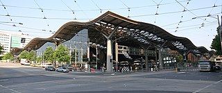
Domain Interchange was a major interchange on the Melbourne tram system. At closure, it featured two island platforms with four tracks, and had dedicated turning tracks and through tracks. It was located on St Kilda Road between Domain Road and Park Street, adjacent to Kings Domain, and was one of the busiest interchanges on the system, being used by eight tram routes. The most recent structure was opened in April 2013, replacing an earlier structure built in 1986.

The Melbourne tram network began in 1884 with the construction of the Fairfield Horse Tramway. However, the purpose of the line was to increase land prices in the area, and it soon closed during the depression in 1890. The first genuine attempt to construct a tramway network was the construction of the Richmond cable tram line by the Melbourne Tramway & Omnibus Company in 1885. Over the next few years, 16 more cable tram lines were constructed, as well as numerous other horse tramways. The depression of the early 1890s slowed further expansion of the cable network. The first electric tram line was the Box Hill and Doncaster tramway which opened in 1889. This was a pioneering line in what was then the countryside and thus didn't receive much patronage. It closed in 1896. The next attempt at an electric tramway was Victorian Railways' St Kilda to Brighton line, which opened in 1906. Later that year, the North Melbourne Electric Tramway & Lighting Company opened lines to Essendon and Maribyrnong. Many local councils formed their own tramway trusts and built tramways within their own constituency. The most successful of these was the Prahran & Malvern Tramways Trust.

References

  1. Metro Tunnel to Transform Melbourne's Tram Network Minister for Public Transport 25 October 2016
  2. Trams to head west, route 58 to be born in network overhaul next year The Age 25 October 2016
  3. New Tram Timetable Newsrail June 2017 page 182
  4. Toorak West Track Opens Newsrail August 2017 page 247
  5. Route 58 infrastructure upgrades Public Transport Victoria
  6. Route 58 stop changes Yarra Trams
  7. New tram timetables and E-Class trams for Route 58 Public Transport Victoria
  8. Melville Road upgrade creates accessible tram hub for Route 58 passengers Railway Digest April 2020 page 24
  9. Works along route 58 Newsrail August 2021 page 276

Commons-logo.svg Media related to Melbourne tram route 58 at Wikimedia Commons