Melbourne tram route 64

Last updated

Route 64
A2.292 swanston.JPG
Overview
System Melbourne
Operator Yarra Trams
Depot Glenhuntly
Vehicle Z class
B class
Began service16 October 1938
Route
Start Melbourne University
Via Swanston Street
St Kilda Road
Dandenong Road
Hawthorn Road
End Brighton East
Length16.1 kilometres
Timetable Route 64 timetable
Map Route 64 map
  Route 59  {{{system_nav}}}  Route 67  

Melbourne tram route 64 is operated by Yarra Trams on the Melbourne tram network from Melbourne University to Brighton East. The 18.1 kilometre route is operated out of Glenhuntly depot with Z and B class trams.

Contents

After 19:00, passengers for route 5 to Malvern are required to board route 64 (marked 64/5) and transfer to route 5 shuttles on Dandenong Road.

History

Route 64 was allocated to the line between Brighton East and City (Swanston Street) on 16 October 1938. Prior to that, Route 64 was allocated to the line between Brighton East and St Kilda Beach via St Kilda Junction. [1] Between 1938 and 9 July 1955, Route 64 ran via Balaclava Road rather than Dandenong Road. Trams traditionally terminated at the Victoria Street terminus, but following an accident in 1991, trams instead terminated at the Queensberry Street crossover. Due to congestion during peak hours at the crossover, some trams continued north to Melbourne University. Finally on 17 January 1996, a permanent shunt was built at Melbourne University. [1] From then on, Route 64 trams were altered run full-time to Melbourne University.

The origins of route 5 lie in separate tram lines. The section of track between Queensberry Street (Stop 4) and St Kilda Road (Stop 30) is the oldest section of this route, dating back to the Brighton Road cable tram which opened on 11 October 1888 by the Melbourne Tramway & Omnibus Company. This cable tram line was electrified in stages by the Melbourne & Metropolitan Tramways Board (MMTB). [1] The section between Domain Interchange (Stop 20) and St Kilda Junction (Stop 30) was electrified on 27 December 1925. The section between Queensberry Street and City Road (near Stop 14) was electrified on the same day. The line between City Road and Domain Interchange was electrified on 24 January 1926. The section between St Kilda Junction and Chapel Street (Stop 32) also dates back to the cable era, as the Windsor to St Kilda Esplanade cable tramway which opened on 17 October 1891. This section was one of the first cable trams to be converted to electric traction on 27 December 1925. [1]

The Prahran & Malvern Tramways Trust built the section between the Sandringham railway line (near Stop 33) and Hawthorn Road (Stop 48), opening on 16 December 1911. This line was extended to Chapel Street (Stop 32) on 31 March 1912. The line between Hawthorn Road and Balaclava Road (Stop 51) opened on 12 April 1913. This was later extended to Glenhuntly Road (Stop 57) on 13 November 1913. Further extensions of the Hawthorn Road line were built by the MMTB to North Road (on 1 March 1925), and to Point Nepean Road on 5 December 1937. [1]

As part of the St Kilda Junction separation works, the Wellington Street section was abandoned for a new section of track along the newly created Queens Way on 4 November 1968. [1]

Melbourne tram route 64 evolution
DatesRouteNotes
24 June 1934 - 4 December 1937Brighton Cemetery to St Kilda Beach via Dandenong Road
5 December 1937 - 15 October 1938 Brighton East to St Kilda Beach via Dandenong Road
16 October 1938 - 9 July 1955 Brighton East to City (Victoria / Swanston Streets)via Balaclava Road
10 July 1955 - 14 April 1991 Brighton East to City (Victoria Street)via Dandenong Road, rerouted to Queens Way 11 April 1968
15 April 1991 - 16 January 1996 Brighton East to City (Queensberry / Swanston Streets)via Dandenong Road
17 January 1996 - present Brighton East to Melbourne University via Dandenong Road

Operation

Route 64 is operated out of Glenhuntly depot with Z and B class trams. [2] [3] [4]

Route map

Melbourne Tram Route 64
Melbourne University - Brighton East
via City, Windsor & Caulfield South
Free tram zone covers stops 8 to 13, fare zone 1 applies from stop 1 to 7, 14 to 68
Suburb
Street
Stop
No.
Melbourne University
Connections
BSicon uCONTg.svg
continues as Tram 1 & 6
towards East Coburg & Moreland
1
BSicon uACC.svg
Melbourne University
BSicon TRAM.svg
1, 3/3a, 5, 6
16, 67, 72
; Bus-logo.svg
401, 402
403, 546
3
BSicon uACC.svg
Lincoln Square
4
BSicon uACC.svg
Queensberry Street
BSicon uCONTgq.svg
BSicon uABZg+r.svg
Victoria Street
No Service
7
BSicon exBLq.svg
BSicon uACC.svg
BSicon exBLq.svg
RMIT University
BSicon uCONTgq.svg
BSicon uKRZr.svg
BSicon uKRZ.svg
BSicon uCONTfq.svg
La Trobe Street
Tram 30, City Circle
BSicon lv-INT.svg
BSicon tCONTg@Gq.svg
BSicon umKRZt.svg
BSicon tCONTfq.svg
Aiga railtransportation 25.svg
Melbourne Central station
8
BSicon uACC.svg
Melbourne Central station
10
BSicon uACC.svg
Bourke Street Mall
BSicon uCONTgq.svg
BSicon uKRZ.svg
BSicon uCONTfq.svg
Bourke Street
Tram 86, 96
BSicon uCONTgq.svg
BSicon uKRZ.svg
BSicon uCONTfq.svg
Collins Street
Tram 11, 12, 48, 109
11
BSicon uACC.svg
Collins Street
BSicon TRAM.svg 11, 12, 48, 109
BSicon uCONTgq.svg
BSicon uKRZ.svg
BSicon uCONTfq.svg
Flinders Street
Tram 70, 75, City Circle
BSicon lv-INT.svg
BSicon CONTg@Gq.svg
BSicon umKRZo.svg
BSicon CONTfq.svg
Aiga railtransportation 25.svg
Flinders Street station
13
BSicon uACC.svg
Flinders Street station
14
BSicon exBLq.svg
BSicon uACC.svg
BSicon exBLq.svg
Arts Precinct
BSicon TRAM.svg 1; Bus-logo.svg
216, 219
220
BSicon uCONTgq.svg
BSicon uABZgr.svg
Southbank Boulevard
Tram 1
17
BSicon uBHF.svg
Grant Street - Police Memorial
19
BSicon uBHF.svg
Shrine of Remembrance
BSicon uCONTgq.svg
BSicon uABZg+r.svg
Park Street
Tram 58
20
BSicon exBLq.svg
BSicon uACC.svg
BSicon exBLq.svg
Domain Interchange
BSicon TRAM.svg 58
BSicon ueABZgl.svg
BSicon uexCONTfq.svg
Domain Road
No Service (Temporary Closure)
21
BSicon uBHF.svg
Bowen Crescent
22
BSicon uBHF.svg
Toorak Road
BSicon TRAM.svg 58
BSicon uABZgl.svg
BSicon uCONTfq.svg
Toorak Road
Tram 58
Toorak Arrow Blue Right 001.svg
 
23
BSicon uACC.svg
Arthur Street
24
BSicon uACC.svg
Leopold Street
25
BSicon uACC.svg
Commercial Road
BSicon TRAM.svg 72; Bus-logo.svg 216, 219, 220
BSicon uABZgl.svg
BSicon uCONTfq.svg
Commercial Road
Tram 72
26
BSicon uACC.svg
Moubray Street
27
BSicon uACC.svg
High Street
BSicon uABZgl.svg
BSicon uCONTfq.svg
High Street
Tram 6
29
BSicon uACC.svg
Union Street
30
BSicon exBLq.svg
BSicon uBHF.svg
BSicon exBLq.svg
St Kilda Junction
BSicon TRAM.svg 3/3a, 16, 67
BSicon uCONTgq.svg
BSicon uABZgr.svg
St Kilda Road
Tram 3/3a, 16, 67
Windsor
Upton Road
31
BSicon exBLq.svg
BSicon uBHF.svg
BSicon exBLq.svg
Queens Way
32
BSicon uACC.svg
BSicon KBL2.svg
BSicon BLc3.svg
BSicon CONT1+f.svg
Chapel Street
BSicon TRAM.svg 78
BSicon BLc1.svg
BSicon uSTR.svg
BSicon BHF.svg
BSicon KBL4.svg
Aiga railtransportation 25.svg Windsor station
BSicon uCONTgq.svg
BSicon uKRZ.svg
BSicon uCONTf@Fq.svg
BSicon TUNNEL1.svg
Chapel Street
Tram 78
33
BSicon tSTRc2.svg
BSicon uBHF.svg
BSicon tSTR3a.svg
Hornby Street
34
BSicon tSTRc2.svg
BSicon uACC.svg
BSicon tSTR3+1.svg
BSicon tSTRc4.svg
The Avenue
35
BSicon tSTR3+1e@g.svg
BSicon lCONTf3.svg
BSicon tSTRc4.svg
BSicon uACC.svg
Williams Road
36
BSicon exBLq.svg
BSicon uACC.svg
BSicon exBLq.svg
Closeburn Avenue
37
BSicon uACC.svg
Lansdowne Road
38
BSicon exBLq.svg
BSicon uACC.svg
BSicon exBLq.svg
Orrong Road
40
BSicon uACC.svg
Wattletree Road
BSicon TRAM.svg 5
BSicon uABZgl.svg
BSicon uCONTfq.svg
Wattletree Road
Tram 5
42
BSicon uACC.svg
Kooyong Road
43
BSicon uBHF.svg
Egerton Road
44
BSicon uBHF.svg
Bailey Avenue
48
BSicon exBLq.svg
BSicon uACC.svg
BSicon exBLq.svg
Hawthorn Road
BSicon TRAM.svg 16
BSicon uABZgl+l.svg
BSicon uCONTfq.svg
Dandenong Road
Tram 16
Kew Arrow Blue Right 001.svg
 
 
Hawthorn Road
48A
BSicon uBHF(R)g.svg
Dandenong Road
49
BSicon uHST.svg
Arthur Street
50
BSicon uHST.svg
Inkerman Road
BSicon uCONTgq.svg
BSicon uKRZlr+lr.svg
BSicon uCONTfq.svg
Balaclava Road
Tram 3, 16
51
BSicon uHST.svg
Balaclava Junction
BSicon TRAM.svg 3, 16
52
BSicon uHST.svg
Halstead Street
53
BSicon uHST.svg
Northcote Avenue
Caulfield
Hawthorn Road
54
BSicon exBLq.svg
BSicon uBHF.svg
BSicon exBLq.svg
Glen Eira Road
Bus-logo.svg 623
55
BSicon uHST.svg
Sylverly Grove
56
BSicon uHST.svg
Briggs Street
57
BSicon uHST.svg
Glen Huntly Road
BSicon TRAM.svg 67
BSicon uCONTgq.svg
BSicon uSTRq.svg
BSicon uABZgl+l.svg
BSicon uCONTfq.svg
Glen Huntly Road
Tram 67
Caulfield South
Hawthorn Road
58
BSicon exBLq.svg
BSicon uHST.svg
BSicon exBLq.svg
Sycamore Street
59
BSicon uHST.svg
Princes Park
60
BSicon uHST.svg
Dover Street
Bus-logo.svg 625
61
BSicon uHST.svg
Stone Street
62
BSicon uHST.svg
Gardenvale Road
63
BSicon uHST.svg
North Road
Bus-logo.svg 626, 630
Brighton East
Hawthorn Road
64
BSicon exBLq.svg
BSicon uHST.svg
BSicon exBLq.svg
Taylor Street
65
BSicon uHST.svg
Davey Avenue
66
BSicon uHST.svg
Union Street
Bus-logo.svg 626
67
BSicon uHST.svg
Rogers Avenue
68
BSicon uKACCe.svg
Nepean Highway
Bus-logo.svg 703
Suburb
Street
Stop
No.
Brighton East
Connections

Related Research Articles

<span class="mw-page-title-main">Trams in Melbourne</span> Public transport network in Victoria, Australia

Trams are a major form of public transport in Melbourne, the capital city of the state of Victoria, Australia. As of May 2017, the Melbourne tramway network consists of 250 kilometres of double track, 493 trams, 24 routes, and 1,763 tram stops. The system is the largest operational urban tram network in the world. Trams are the second most used form of public transport in overall boardings in Melbourne after the commuter railway network, with a total of 206 million passenger trips in 2017–18.

<span class="mw-page-title-main">Melbourne tram route 72</span>

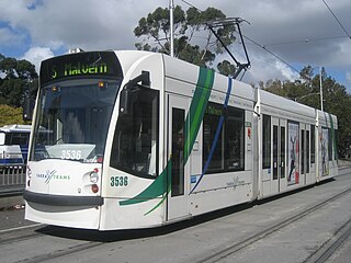
Melbourne tram route 72 is operated by Yarra Trams on the Melbourne tram network from Melbourne University to Camberwell. The 16.8 kilometre route is operated out of Malvern depot with Z and D class trams.

<span class="mw-page-title-main">Melbourne tram route 6</span>

Melbourne tram route 6 is operated by Yarra Trams on the Melbourne tram network from Moreland to Glen Iris. The 19.2 kilometre route is operated out of Brunswick and Malvern depots with Z, B and D class trams.

<span class="mw-page-title-main">Melbourne tram route 5</span>

Melbourne tram route 5 is operated by Yarra Trams on the Melbourne tram network from Melbourne University to Malvern. The 12.6 kilometre route is operated out of Malvern depot with Z and D1 class trams.

<span class="mw-page-title-main">Melbourne tram route 112</span>

Melbourne tram route 112 was operated by Yarra Trams on the Melbourne tram network from West Preston to St Kilda. The 18 kilometre route was operated out of East Preston depot with A, B and D2 class trams.

<span class="mw-page-title-main">Melbourne tram route 96</span>

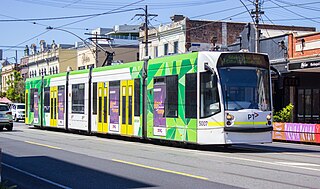
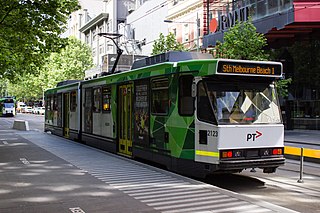
Melbourne tram route 96 is operated by Yarra Trams on the Melbourne tram network from Brunswick East to St Kilda Beach. The 13.9 kilometre route is operated out of Southbank depot with C2 and E class trams.

<span class="mw-page-title-main">Melbourne tram route 75</span>

Melbourne tram route 75 is operated by Yarra Trams on the Melbourne tram network from Vermont South to Central Pier. The 22.8 kilometre route is operated out of Camberwell depot with A and B class trams. It is the longest route on the network.

<span class="mw-page-title-main">Melbourne tram route 16</span>

Melbourne tram route 16 is operated by Yarra Trams on the Melbourne tram network from Melbourne University to Kew. The 20.2 kilometre route is operated out of Malvern depot with Z and D1 class trams.

<span class="mw-page-title-main">Melbourne tram route 67</span>

Melbourne tram route 67 is operated by Yarra Trams on the Melbourne tram network from Melbourne University to Carnegie. The 12.7 kilometre route is operated out of Glenhuntly depot with Z and B class trams.

<span class="mw-page-title-main">Melbourne cable tramway system</span> Cable car public transport system in Melbourne, Australia

The Melbourne cable tramway system was a cable car public transport system, which operated between 1885 and 1940 in Melbourne, Victoria, Australia.

<span class="mw-page-title-main">Melbourne tram route 1</span>

Melbourne tram route 1 is operated by Yarra Trams on the Melbourne tram network from East Coburg to South Melbourne Beach. The 13.2 kilometre route is operated out of Brunswick depot with Z and B class trams.

<span class="mw-page-title-main">Melbourne tram route 78</span>

Melbourne tram route 78 is operated by Yarra Trams on the Melbourne tram network from North Richmond to Balaclava. The 6.5 kilometre route is operated out of Kew depot with A class trams.

<span class="mw-page-title-main">Melbourne tram route 3</span>

Melbourne tram route 3 is operated by Yarra Trams on the Melbourne tram network from Melbourne University to Malvern East. The 14.9 kilometre route is operated out of Glenhuntly depot with Z and B class trams. On weekends route 3 operates as route 3a and diverts via St Kilda Beach.

<span class="mw-page-title-main">Melbourne tram route 11</span>

Melbourne tram route 11 is operated by Yarra Trams on the Melbourne tram network from West Preston to Victoria Harbour. The 13.4 kilometre route is operated out of Preston depot with E class trams.

<span class="mw-page-title-main">Melbourne & Metropolitan Tramways Board</span> Government-owned authority in Victoria, Australia

The Melbourne & Metropolitan Tramways Board (MMTB) was a government-owned authority that was responsible for the tram network in Melbourne, Australia between 1919 and 1983, when it was merged into the Metropolitan Transit Authority. It had been formed by the merger of a number of smaller tramway trusts and companies that operated throughout the city.

<span class="mw-page-title-main">Preston Workshops</span>

Preston Workshops is the heavy maintenance facility for the Melbourne tram network. The workshop is located on a block surrounded by Miller Street, St George's Road, Oakover Road and the Mernda railway line in Preston, a suburb of Melbourne, Australia. Following a major redevelopment in April 2016, it also became an operational depot under the name New Preston Depot, taking over from East Preston.

<span class="mw-page-title-main">Domain Interchange</span>

Domain Interchange was a major interchange on the Melbourne tram system. At closure, it featured two island platforms with four tracks, and had dedicated turning tracks and through tracks. It was located on St Kilda Road between Domain Road and Park Street, adjacent to Kings Domain, and was one of the busiest interchanges on the system, being used by eight tram routes. The most recent structure was opened in April 2013, replacing an earlier structure built in 1986.

<span class="mw-page-title-main">Melbourne tram route 12</span> Tram route in metropolitan Melbourne, Victoria, Australia

Melbourne tram route 12 is operated by Yarra Trams on the Melbourne tram network from Victoria Gardens Shopping Centre to St Kilda. The 16.2 kilometre is operated out of Southbank depot with A class trams.

<span class="mw-page-title-main">Melbourne tram route 58</span>

Melbourne tram route 58 is operated by Yarra Trams on the Melbourne tram network from West Coburg to Toorak. The 18.0 kilometre route is operated out of Essendon and Southbank depots with Z, B and E class trams.

The Melbourne tram network began in 1884 with the construction of the Fairfield Horse Tramway. However, the purpose of the line was to increase land prices in the area, and it soon closed during the depression in 1890. The first genuine attempt to construct a tramway network was the construction of the Richmond cable tram line by the Melbourne Tramway & Omnibus Company in 1885. Over the next few years, 16 more cable tram lines were constructed, as well as numerous other horse tramways. The depression of the early 1890s slowed further expansion of the cable network. The first electric tram line was the Box Hill and Doncaster tramway which opened in 1889. This was a pioneering line in what was then the countryside and thus didn't receive much patronage. It closed in 1896. The next attempt at an electric tramway was Victorian Railways' St Kilda to Brighton line, which opened in 1906. Later that year, the North Melbourne Electric Tramway & Lighting Company opened lines to Essendon and Maribyrnong. Many local councils formed their own tramway trusts and built tramways within their own constituency. The most successful of these was the Prahran & Malvern Tramways Trust.

References

  1. 1 2 3 4 5 6 "Gunzel". www.classicaustraliantv.com. Retrieved 2 October 2018.
  2. Glenhuntly Depot Vicsig
  3. Facts & figures Yarra Trams
  4. Route 64 Yarra Trams

Commons-logo.svg Media related to Melbourne tram route 64 at Wikimedia Commons